Steam Plains NSW 2710
7 addresses · 3 streets
Farrer Electorate › Edward River LGA › Steam Plains · 555 km from Sydney

Getting Around & Local Services
Tree cover
🌳 Tree canopy: 0.9% share of land under canopy · satellite map, 2020
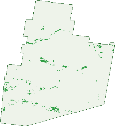
Green: 10 m cells where trees dominate, satellite 2021. Blue: water. The line is the suburb boundary.
| Canopy share, 1 m canopy height map, 2020 | 0.9% |
|---|---|
| Land with trees, 10 m satellite map, 2021 | 2.1% |
Demographics
Population by age in Steam Plains
| 0-4 | 0 |
|---|---|
| 5-14 | 0 |
| 15-19 | 0 |
| 20-24 | 0 |
| 25-34 | 0 |
| 35-44 | 0 |
| 45-54 | 3 |
| 55-64 | 0 |
| 65-74 | 0 |
| 75-84 | 0 |
| 85+ | 0 |
Top ancestries in Steam Plains
| English | 3 |
|---|---|
| Australian | 0 |
| Aboriginal | 0 |
| Chinese | 0 |
| Croatian | 0 |
| Dutch | 0 |
Commute to work in Steam Plains
| Car | 0 |
|---|---|
| Train | 0 |
| Bus | 0 |
| Tram/ferry | 0 |
| Walked | 0 |
| Bicycle | 0 |
| Home | 3 |
Birds & Wildlife Nearby
891 bird observations recorded near Steam Plains — most often seen:
- Wedge-tailed Eagle (127)
- Nankeen Kestrel (123)
- Galah (94)
- Brown Songlark (70)
- Australian Magpie (58)
- Black-shouldered Kite (52)
- Black Kite (38)
- Little Raven (38)
- Australian Raven (33)
- Red-rumped Parrot (23)
- Pied Butcherbird (20)
- Willie Wagtail (20)
- Common Starling (17)
Show all 30 birds recorded near Steam Plains
- Australian Pipit (15)
- Bluebonnet (15)
- Magpie-lark (15)
- White-winged Fairy-wren (15)
- Crested Pigeon (13)
- Noisy Miner (13)
- Tree Martin (13)
- Horsfield's Bushlark (12)
- Black-faced Woodswallow (11)
- Stubble Quail (11)
- Welcome Swallow (10)
- Black Falcon (9)
- Brown Falcon (9)
- Singing Honeyeater (5)
- Australian Pelican (4)
- Black-faced Cuckoo-shrike (4)
- Emu (4)
Sightings reported by observers, not a survey, so the counts show what people record rather than what lives here. Source: Atlas of Living Australia.
Nearby Suburbs
The closest suburbs to Steam Plains:
- Four Corners (17.6 km)
- Mabins Well (20.8 km)
- Willurah (23.2 km)
- Moonbria (24.2 km)
- Argoon (36.2 km)
- Conargo (41.2 km)
- Gala Vale (43.1 km)
- Hartwood (46.2 km)
Embed this suburb
Add this free Steam Plains stat card to your own site — just copy the code:
Preview:
Cite this page
Quoting these figures? Copy the credit line:
Keep an eye on Steam Plains
One email when this data meaningfully changes — new census figures, prices, rankings. No spam, unsubscribe anytime.
Streets
- Bullewah Road (4)
- Carrathool Road (2)
- North Boundary Road (1)