Sawtell NSW 2452
2,593 addresses · 61 streets
Cowper Electorate › Coffs Harbour LGA › Sawtell · 428 km from Sydney
📦 Thinking of moving here? Read the Sawtell moving guide

Living Here
Sawtell is a suburb of New South Wales, home to about 3,788 people, with a median age of 47. The typical household earns around $1,405 a week, with median rent near $380 a week. Most homes are houses. About 66% of households own their home and 33% rent. Most workers drive to work. Common community backgrounds include English, Australian, Irish. On the ABS socio-economic scale it sits in decile 6 of 10 nationally — a mid-range area.
Over time — Census 2001 → 2021
Dashed line: district figures for the Sawtell - Boambee statistical area (SA2), the smallest area the ABS published before 2011. Solid line: Sawtell itself.
Getting Around & Local Services
11 schools
- Sawtell Public School
- Gamumbi Early Childhood Education Centre
- Mary Help of Christians Primary School
- William Bayldon Public School
- Toormina Public School
- Coffs Harbour Bible Church School
- Coffs Harbour Learning Centre
- Coffs Harbour Christian Community School Senior Campus
- St John Paul College
- Boambee Public School
3 supermarkets
2 beaches
2 Catholic churches
1 pharmacy
2 doctors & medical clinics
2 dentists
1 vet
1 childcare centre
1 library
2 post offices
3 service stations
2 gyms & sports centres
2 playgrounds
1 bakery
2 electricians
Getting around. Train station: Sawtell, 950 m north · Airport: Coffs Harbour Regional Airport, 5.7 km north.
Socio-economic Standing
Deciles from 1 (lowest) to 10 (highest), against all Australian suburbs. The overall figure weighs advantage and disadvantage together; economic resources counts income and housing, and education & jobs counts qualifications and occupation. They often differ. Source: ABS SEIFA 2021.
Tree cover
🌳 Tree canopy: 24.4% share of land under canopy · satellite map, 2020
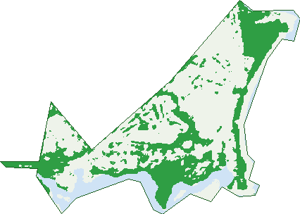
Green: 10 m cells where trees dominate, satellite 2021. Blue: water. The line is the suburb boundary.
| Canopy share, 1 m canopy height map, 2020 | 24.4% |
|---|---|
| Land with trees, 10 m satellite map, 2021 | 38.8% |
Demographics
Unemployment 4.6% · Labour-force participation 56%
Population by age in Sawtell
| 0-4 | 178 |
|---|---|
| 5-14 | 440 |
| 15-19 | 205 |
| 20-24 | 130 |
| 25-34 | 358 |
| 35-44 | 434 |
| 45-54 | 535 |
| 55-64 | 554 |
| 65-74 | 571 |
| 75-84 | 288 |
| 85+ | 97 |
Dwelling types in Sawtell
| House | 1,070 |
|---|---|
| Townhouse | 194 |
| Apartment | 260 |
| Other | 38 |
Households by weekly income in Sawtell
| <$650 | 321 |
|---|---|
| $650-1,499 | 468 |
| $1,500-2,999 | 425 |
| $3,000+ | 253 |
Top ancestries in Sawtell
| English | 1,798 |
|---|---|
| Australian | 1,448 |
| Irish | 575 |
| Scottish | 492 |
| Other | 220 |
| Ancestry NS | 209 |
Housing tenure in Sawtell
| Owned | 656 |
|---|---|
| Mortgage | 358 |
| Rented | 506 |
| Other | 20 |
Cars per household in Sawtell
| 0 | 81 |
|---|---|
| 1 | 606 |
| 2 | 608 |
| 3 | 175 |
| 4+ | 66 |
Commute to work in Sawtell
| Car | 1,126 |
|---|---|
| Train | 0 |
| Bus | 3 |
| Tram/ferry | 0 |
| Walked | 48 |
| Bicycle | 20 |
| Home | 246 |
Top countries of birth in Sawtell
| England | 136 |
|---|---|
| New Zealand | 56 |
| South Africa | 25 |
| Scotland | 17 |
| Netherlands | 13 |
| Thailand | 13 |
Languages used at home in Sawtell
| Japanese | 15 |
|---|---|
| Spanish | 12 |
| Thai | 12 |
| French | 11 |
| Afrikaans | 6 |
| Australian Indigenous | 6 |
Birds & Wildlife Nearby
22,175 bird observations recorded near Sawtell — most often seen:
- Rainbow Lorikeet (1,656)
- Lewin's Honeyeater (1,265)
- Noisy Miner (986)
- Australian Brush-turkey (979)
- Magpie-lark (930)
- Australian White Ibis (903)
- Silver Gull (892)
- Laughing Kookaburra (879)
- Australian Magpie (866)
- Eastern Yellow Robin (865)
- Eastern Whipbird (755)
- Pied Currawong (740)
- Torresian Crow (713)
Show all 30 birds recorded near Sawtell
- Australian Pied Oystercatcher (669)
- Welcome Swallow (642)
- Australasian Figbird (640)
- Crested Tern (640)
- Spotted Turtle-dove (632)
- Scaly-breasted Lorikeet (616)
- Grey Fantail (608)
- Cattle Egret (607)
- Eastern Rainbow Lorikeet (556)
- Brown Thornbill (555)
- Crested Pigeon (547)
- Little Black Cormorant (544)
- Little Wattlebird (520)
- Red-browed Finch (511)
- White-faced Heron (507)
- Pacific Black Duck (490)
- Southern Magpie-lark (462)
Sightings reported by observers, not a survey, so the counts show what people record rather than what lives here. Source: Atlas of Living Australia.
Nearby Suburbs
The closest suburbs to Sawtell:
- Toormina (1.6 km)
- Boambee East (2.9 km)
- Boambee (5 km)
- Bonville (5.5 km)
- North Boambee Valley (6.6 km)
- Bundagen (7.4 km)
- Coffs Harbour (8.8 km)
- Repton (10.1 km)
Embed this suburb
Add this free Sawtell stat card to your own site — just copy the code:
Preview:
Cite this page
Quoting these figures? Copy the credit line:
Keep an eye on Sawtell
One email when this data meaningfully changes — new census figures, prices, rankings. No spam, unsubscribe anytime.
Streets
- Alexandra Court (15)
- Bangalow Terrace (41)
- Banool Street (4)
- Bayldon Road (24)
- Bellgrove Street (18)
- Boambee Street (10)
- Bongil Lane (2)
- Bonville Waters Drive (37)
- Boronia Street (230)
- Bridge Street (12)
- Brown Avenue (14)
- Caryota Place (4)
- Circular Avenue (107)
- Coronation Avenue (60)
- Cunningham Crescent (25)
- David Watt Close (15)
- Dillon Street (15)
- Dirrigeree Crescent (64)
- East Street (3)
- Eighteenth Avenue (79)
- Eighth Avenue (33)
- Eleventh Avenue (62)
- Elizabeth Street (102)
- Fifteenth Avenue (26)
- First Avenue (448)
- Fourth Avenue (71)
- Gillibri Crescent (82)
- Harrison Street (36)
- Heron Place (15)
- Hillery Lane (4)
- Honeysuckle Street (45)
- Howea Court (13)
- Hulberts Road (1)
- Ken Place (4)
- Kentia Court (9)
- Kidd Lane (7)
- Livistona Terrace (13)
- Lyons Road (250)
- May Street (13)
- Moller Drive (54)
- Nineteenth Avenue (21)
- Pade Lane (2)
- Palmetto Place (8)
- Park Street (22)
- Royal Palm Drive (63)
- Sabal Drive (30)
- Second Avenue (11)
- Seventeenth Avenue (26)
- Seventh Avenue (18)
- Sixteenth Avenue (86)
- Third Avenue (8)
- Thirteenth Avenue (32)
- Tindara Drive (38)
- Tom Albert Place (28)
- Twentieth Avenue (30)
- Twenty-fifth Avenue (22)
- Twenty-first Avenue (6)
- Twenty-second Avenue (54)
- Twenty-third Avenue (3)
- Wattle Street (2)
- Wonga Close (16)