Ryde NSW 2112
18,720 addresses · 204 streets
Bennelong Electorate › Ryde LGA › Ryde · 11 km from Sydney
📦 Thinking of moving here? Read the Ryde moving guide

Living Here
A northern-Sydney suburb midway between the city and Parramatta, Ryde mixes established homes with new apartments. Households average 2.4 people and the median age is 36. Median household income is $2,024 a week, with rent about $465.
Ryde is a suburb of New South Wales, home to about 31,907 people, with a median age of 36. The typical household earns around $2,024 a week, with median rent near $465 a week. Most homes are apartments. About 53% of households own their home and 46% rent. Most workers work from home. Common community backgrounds include Chinese, English, Australian. On the ABS socio-economic scale it sits in decile 10 of 10 nationally — a relatively advantaged area.
Over time — Census 2001 → 2021
Dashed line: district figures for the Ryde - Putney statistical area (SA2), the smallest area the ABS published before 2011. Solid line: Ryde itself.
Getting Around & Local Services
4 optometrists
2 carpenters
Getting around. Train station: Meadowbank, 1.5 km west · Metro station: North Ryde, 3.7 km north-east · Bus interchange: STA Ryde Depot, 1.6 km east · Ferry wharf: Meadowbank, 1.7 km south-west · Airport: Rose Bay Seaplane Base, 15.8 km south-east.
Socio-economic Standing
Deciles from 1 (lowest) to 10 (highest), against all Australian suburbs. The overall figure weighs advantage and disadvantage together; economic resources counts income and housing, and education & jobs counts qualifications and occupation. They often differ. Source: ABS SEIFA 2021.
Tree cover
🌳 Tree canopy: 17.3% share of land under canopy · satellite map, 2020
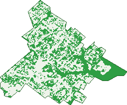
Green: 10 m cells where trees dominate, satellite 2021. Blue: water. The line is the suburb boundary.
| Canopy share, 1 m canopy height map, 2020 | 17.3% |
|---|---|
| Surveyed canopy, Greater Sydney aerial survey, 2019 | 23.3% |
| Land with trees, 10 m satellite map, 2021 | 42.8% |
Demographics
Unemployment 4.9% · Labour-force participation 64.7%
Population by age in Ryde
| 0-4 | 2,017 |
|---|---|
| 5-14 | 3,420 |
| 15-19 | 1,311 |
| 20-24 | 1,838 |
| 25-34 | 6,352 |
| 35-44 | 5,692 |
| 45-54 | 3,626 |
| 55-64 | 3,226 |
| 65-74 | 2,304 |
| 75-84 | 1,384 |
| 85+ | 736 |
Dwelling types in Ryde
| House | 4,409 |
|---|---|
| Townhouse | 1,092 |
| Apartment | 6,941 |
| Other | 3 |
Households by weekly income in Ryde
| <$650 | 1,621 |
|---|---|
| $650-1,499 | 2,837 |
| $1,500-2,999 | 3,844 |
| $3,000+ | 3,524 |
Top ancestries in Ryde
| Chinese | 7,097 |
|---|---|
| Other | 7,030 |
| English | 4,984 |
| Australian | 4,857 |
| Italian | 2,551 |
| Irish | 1,819 |
Housing tenure in Ryde
| Owned | 2,764 |
|---|---|
| Mortgage | 3,713 |
| Rented | 5,622 |
| Other | 218 |
Cars per household in Ryde
| 0 | 1,348 |
|---|---|
| 1 | 6,280 |
| 2 | 3,455 |
| 3 | 851 |
| 4+ | 379 |
Commute to work in Ryde
| Car | 5,557 |
|---|---|
| Train | 223 |
| Bus | 458 |
| Tram/ferry | 7 |
| Walked | 307 |
| Bicycle | 24 |
| Home | 7,073 |
Top countries of birth in Ryde
| China | 3,505 |
|---|---|
| India | 1,130 |
| South Korea | 1,018 |
| Iran | 777 |
| Philippines | 699 |
| Hong Kong | 659 |
Languages used at home in Ryde
| Mandarin | 3,715 |
|---|---|
| Cantonese | 1,925 |
| Korean | 1,242 |
| Italian | 761 |
| Arabic | 758 |
| Persian | 676 |
Birds & Wildlife Nearby
254,791 bird observations recorded near Ryde — most often seen:
- Noisy Miner (16,737)
- Rainbow Lorikeet (15,116)
- Australian White Ibis (13,954)
- Superb Fairy-wren (13,875)
- Australian Raven (13,028)
- Australian Magpie (11,743)
- Welcome Swallow (11,369)
- Pied Currawong (11,293)
- Chestnut Teal (9,618)
- Silver Gull (9,282)
- Dusky Moorhen (8,909)
- Pacific Black Duck (8,513)
- White-faced Heron (7,994)
Show all 30 birds recorded near Ryde
- Magpie-lark (7,634)
- Laughing Kookaburra (7,619)
- Masked Lapwing (7,593)
- Grey Butcherbird (7,452)
- Sulphur-crested Cockatoo (7,093)
- Eurasian Coot (6,385)
- Little Pied Cormorant (6,206)
- Willie Wagtail (6,145)
- Common Myna (5,865)
- Red Wattlebird (5,574)
- Grey Teal (5,381)
- Australian Pelican (5,300)
- Silvereye (5,287)
- Little Black Cormorant (5,152)
- Black Swan (5,040)
- Australian Brush-turkey (4,993)
- Australian Wood Duck (4,641)
Sightings reported by observers, not a survey, so the counts show what people record rather than what lives here. Source: Atlas of Living Australia.
Nearby Suburbs
The closest suburbs to Ryde:
- Putney (1.3 km)
- Meadowbank (1.5 km)
- West Ryde (1.9 km)
- Denistone (2.1 km)
- Denistone East (2.1 km)
- Tennyson Point (2.2 km)
- Rhodes (2.5 km)
- Gladesville (2.6 km)
Embed this suburb
Add this free Ryde stat card to your own site — just copy the code:
Preview:
Cite this page
Quoting these figures? Copy the credit line:
Keep an eye on Ryde
One email when this data meaningfully changes — new census figures, prices, rankings. No spam, unsubscribe anytime.
Streets
- Abaroo Street (4)
- Acacia Avenue (66)
- Adam Street (9)
- Addington Avenue (43)
- Aeolus Avenue (108)
- Aitchandar Road (70)
- Allan Avenue (25)
- Anderson Avenue (37)
- Argyle Avenue (53)
- Arnold Street (32)
- Arras Parade (19)
- Arthur Street (65)
- Badajoz Road (74)
- Baird Avenue (34)
- Bambi Street (3)
- Bavin Avenue (20)
- Beazley Street (86)
- Belmore Street (1,042)
- Bennelong Way (15)
- Betola Street (16)
- Bidgee Road (29)
- Bird Street (36)
- Blaxland Road (1,114)
- Bowden Street (140)
- Boyce Street (37)
- Brian Street (17)
- Bridge Road (85)
- Bright Street (32)
- Bruce Street (49)
- Buffalo Road (241)
- Buna Street (14)
- Burke Street (7)
- Bygrave Street (22)
- Byron Avenue (21)
- Callaghan Street (53)
- Cameron Crescent (27)
- Charles Street (107)
- Chatfield Street (15)
- Christine Avenue (53)
- Church Lane (1)
- Church Street (469)
- Clayton Street (45)
- Clermont Avenue (53)
- Colebee Street (23)
- Collingridge Drive (84)
- Colston Street (33)
- Constitution Road (565)
- Cosimo Place (13)
- Cowell Street (29)
- Crescent Avenue (34)
- Cressy Road (87)
- Cross Street (16)
- Curtis Street (13)
- Curzon Street (185)
- Devlin Street (633)
- Dobson Crescent (24)
- Dolan Street (23)
- Dorothy Street (51)
- Dunbar Street (26)
- Dwyer Street (8)
- Eagle Street (45)
- Eden Street (7)
- Edward Street (122)
- Eileen Street (12)
- Elizabeth Street (35)
- Ellen Street (38)
- Eulo Parade (17)
- Fawcett Street (85)
- Fernleigh Close (14)
- Fisher Avenue (40)
- Forrest Road (67)
- Frank Street (1)
- Frederick Street (73)
- Gale Street (12)
- Gardener Avenue (76)
- Gladstone Avenue (85)
- Goulding Road (197)
- Gowrie Street (46)
- Greene Avenue (80)
- Hamilton Cr (1)
- Hamilton Crescent (428)
- Hancott Street (81)
- Hatton Street (80)
- Heath Lane (6)
- Heath Street (51)
- Henry Street (32)
- Higginbotham Road (41)
- Hinkler Avenue (36)
- Holly Avenue (8)
- Irvine Crescent (57)
- Isabel Street (189)
- Ivy Street (12)
- Jennifer Street (14)
- John Miller Street (79)
- Jones Street (102)
- Junction Street (191)
- Karen Moras Drive (1)
- Keats Avenue (10)
- Kells Road (49)
- Kenneth Street (8)
- Keppel Road (39)
- Kulgoa Avenue (116)
- Kuppa Road (53)
- Lane Cove Road (267)
- Lardelli Drive (608)
- Laurel Place (12)
- Lavarack Street (83)
- Lee Avenue (7)
- Linley Way (54)
- Little Church Street (18)
- Lock Street (8)
- Lyle Street (22)
- Macleay Street (39)
- Macpherson Lane (1)
- Malvina Street (82)
- Margaret Street (21)
- Martin Street (11)
- Maze Avenue (20)
- Meikle Place (101)
- Meldrum Street (2)
- Melville Street (36)
- Meta Street (10)
- Milne Street (39)
- Minga Street (36)
- Morrison Road (370)
- Myra Avenue (58)
- Nanbaree Road (16)
- Nancarrow Avenue (1,104)
- Nerang Street (29)
- Neville Street (43)
- Niara Street (8)
- Nicoll Avenue (17)
- North Road (121)
- Olive Street (63)
- Olivieri Place (7)
- Parkes Street (49)
- Parry Street (20)
- Parsonage Street (1)
- Pidding Road (10)
- Pooley Street (49)
- Pope Street (747)
- Porter Street (1,669)
- Potts Street (83)
- Pratten Avenue (22)
- Price Street (185)
- Primrose Avenue (23)
- Princes Street (92)
- Providence Road (48)
- Quarry Road (452)
- Ratcliffe Street (32)
- Readford Place (7)
- Redshaw Street (9)
- Richard Johnson Crescent (31)
- Rickard Street (24)
- Robert Street (7)
- Robinson Street (28)
- Rocca Street (39)
- Ronald Avenue (63)
- Rothesay Avenue (4)
- Salerwong Place (21)
- Samuel Street (72)
- Santarosa Avenue (38)
- Searle Street (23)
- Semple Street (11)
- Sewell Street (15)
- Shepherd Street (91)
- Simpson Street (6)
- Small Street (5)
- Smalls Road (59)
- Smith Street (183)
- Squire Street (30)
- St Annes Street (151)
- Stephen Avenue (13)
- Stuart Street (30)
- Susan Schardt Way (31)
- Sutherland Avenue (7)
- Suttor Avenue (22)
- Tennyson Road (15)
- Thistle Street (14)
- Thorn Street (34)
- Toni Crescent (5)
- Tucker Street (2)
- Tunks Street (58)
- Turner Avenue (18)
- Turner Street (3)
- Twin Road (2)
- Tyagarah Street (6)
- Victoria Road (948)
- Wallumai Place (12)
- Wandoo Avenue (41)
- Warren Street (38)
- Watt Avenue (54)
- Watts Road (69)
- Weaver Street (15)
- Well Street (2)
- Wellington Road (15)
- Willandra Street (27)
- William Street (206)
- Willow Crescent (39)
- Wolger Road (67)
- Wolseley Road (12)
- Woodbine Crescent (77)
- Yerong Street (17)
- Zola Avenue (38)