Randwick NSW 2031
19,444 addresses · 184 streets
Kingsford Smith Electorate › Randwick LGA › Randwick · 6 km from Sydney
📦 Thinking of moving here? Read the Randwick moving guide

Living Here
An affluent eastern-Sydney suburb near the coast, major hospitals and a university, Randwick mixes apartments with period homes. Households average 2.2 people and the median age is 36. Median household income is high at $2,422 a week, with rent around $572.
Randwick is a suburb of New South Wales, home to about 28,943 people, with a median age of 36. The typical household earns around $2,422 a week, with median rent near $572 a week. Most homes are apartments. About 47% of households own their home and 51% rent. Most workers work from home. Common community backgrounds include English, Australian, Irish. On the ABS socio-economic scale it sits in decile 10 of 10 nationally — a relatively advantaged area.
Over time — Census 2001 → 2021
Dashed line: district figures for the Randwick statistical area (SA2), the smallest area the ABS published before 2011. Solid line: Randwick itself.
Getting Around & Local Services
39 Catholic churches
59 hospitals
1 carpenter
Getting around. Train station: Bondi Junction, 2.5 km north · Metro station: Waterloo, 4.3 km north-west · Light rail stop: Randwick, 500 m south-west · Bus interchange: Juniors Kingsford, 1.8 km south-west · Ferry wharf: Double Bay, 4.5 km north · Airport: Rose Bay Seaplane Base, 5.2 km north.
Socio-economic Standing
Deciles from 1 (lowest) to 10 (highest), against all Australian suburbs. The overall figure weighs advantage and disadvantage together; economic resources counts income and housing, and education & jobs counts qualifications and occupation. They often differ. Source: ABS SEIFA 2021.
Tree cover
🌳 Tree canopy: 12.1% share of land under canopy · satellite map, 2020
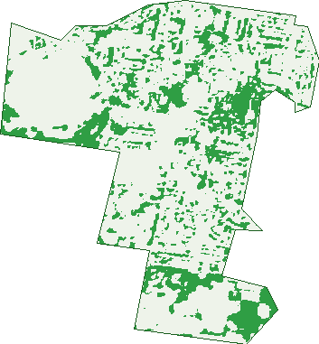
Green: 10 m cells where trees dominate, satellite 2021. Blue: water. The line is the suburb boundary.
| Canopy share, 1 m canopy height map, 2020 | 12.1% |
|---|---|
| Surveyed canopy, Greater Sydney aerial survey, 2019 | 17.4% |
| Land with trees, 10 m satellite map, 2021 | 19.3% |
Demographics
Unemployment 3.6% · Labour-force participation 68.9%
Population by age in Randwick
| 0-4 | 1,569 |
|---|---|
| 5-14 | 2,687 |
| 15-19 | 1,275 |
| 20-24 | 1,774 |
| 25-34 | 6,420 |
| 35-44 | 4,713 |
| 45-54 | 3,635 |
| 55-64 | 2,674 |
| 65-74 | 2,003 |
| 75-84 | 1,336 |
| 85+ | 847 |
Dwelling types in Randwick
| House | 1,626 |
|---|---|
| Townhouse | 1,885 |
| Apartment | 8,047 |
| Other | 213 |
Households by weekly income in Randwick
| <$650 | 1,126 |
|---|---|
| $650-1,499 | 2,005 |
| $1,500-2,999 | 3,430 |
| $3,000+ | 4,579 |
Top ancestries in Randwick
| English | 9,012 |
|---|---|
| Australian | 6,426 |
| Irish | 5,142 |
| Other | 4,865 |
| Scottish | 2,573 |
| Chinese | 1,864 |
Housing tenure in Randwick
| Owned | 2,744 |
|---|---|
| Mortgage | 2,774 |
| Rented | 5,947 |
| Other | 214 |
Cars per household in Randwick
| 0 | 2,078 |
|---|---|
| 1 | 6,262 |
| 2 | 2,689 |
| 3 | 463 |
| 4+ | 168 |
Commute to work in Randwick
| Car | 3,633 |
|---|---|
| Train | 44 |
| Bus | 616 |
| Tram/ferry | 113 |
| Walked | 1,114 |
| Bicycle | 211 |
| Home | 8,153 |
Top countries of birth in Randwick
| England | 2,131 |
|---|---|
| Ireland | 1,248 |
| New Zealand | 615 |
| China | 578 |
| South Africa | 490 |
| Brazil | 343 |
Languages used at home in Randwick
| Mandarin | 682 |
|---|---|
| Spanish | 538 |
| Greek | 437 |
| Portuguese | 406 |
| French | 388 |
| Russian | 375 |
Birds & Wildlife Nearby
271,679 bird observations recorded near Randwick — most often seen:
- Rainbow Lorikeet (20,832)
- Noisy Miner (15,232)
- Australian White Ibis (14,903)
- Rock Dove (12,700)
- Common Myna (11,079)
- Welcome Swallow (10,962)
- Australian Raven (10,533)
- Pied Currawong (10,447)
- Pacific Black Duck (10,135)
- Australian Magpie (10,081)
- Dusky Moorhen (8,829)
- Silver Gull (8,799)
- Magpie-lark (8,593)
Show all 30 birds recorded near Randwick
- Willie Wagtail (8,465)
- Crested Pigeon (8,146)
- Eurasian Coot (8,128)
- Black Swan (8,027)
- Australasian Purple Swamphen (7,692)
- Superb Fairy-wren (7,560)
- Common Starling (7,001)
- Sulphur-crested Cockatoo (6,952)
- Little Black Cormorant (6,838)
- Spotted Turtle-dove (6,767)
- Laughing Kookaburra (6,594)
- Pied Cormorant (6,530)
- Masked Lapwing (6,121)
- Hardhead (6,010)
- Little Pied Cormorant (6,000)
- Australasian Grebe (5,962)
- Australasian Darter (5,761)
Sightings reported by observers, not a survey, so the counts show what people record rather than what lives here. Source: Atlas of Living Australia.
Nearby Suburbs
The closest suburbs to Randwick:
- Coogee (1.2 km)
- Clovelly (1.7 km)
- Kingsford (1.8 km)
- Waverley (1.8 km)
- Queens Park (1.8 km)
- Kensington (1.9 km)
- Bronte (2.1 km)
- South Coogee (2.3 km)
Embed this suburb
Add this free Randwick stat card to your own site — just copy the code:
Preview:
Cite this page
Quoting these figures? Copy the credit line:
Keep an eye on Randwick
One email when this data meaningfully changes — new census figures, prices, rankings. No spam, unsubscribe anytime.
Streets
- Abbey Street (23)
- Ada Street (58)
- Aeolia Street (2)
- Albert Street (279)
- Albi Place (38)
- Albion Street (94)
- Alison Road (1,033)
- Anzac Parade (1)
- Argyle Crescent (10)
- Arthur Lane (1)
- Arthur Street (152)
- Astolat Street (29)
- Avoca Street (961)
- Barden Lane (1)
- Barker Road (2)
- Barker Street (336)
- Barrett Place (5)
- Bell Lane (14)
- Belmore Road (865)
- Bishops Avenue (173)
- Blenheim Street (232)
- Bligh Place (341)
- Botany Street (345)
- Bradley Street (97)
- Budjan Street (1)
- Bundock Lane (30)
- Bundock Street (72)
- Burragulung Street (13)
- Burton Street (67)
- Caerleon Crescent (12)
- Canberra Street (114)
- Carey Street (17)
- Carr Street (2)
- Carrington Road (571)
- Carter Street (12)
- Castle Lane (4)
- Castle Street (21)
- Centennial Avenue (48)
- Challis Lane (1)
- Challis Street (11)
- Chapel Street (11)
- Chatham Street (39)
- Chepstow Street (26)
- Chiltern Street (22)
- Church Lane (7)
- Church Street (247)
- Clara Street (28)
- Clovelly Road (557)
- Clyde Street (32)
- Conway Avenue (13)
- Coogee Bay Road (406)
- Coogee Street (151)
- Cook Street (198)
- Courland Street (47)
- Cowper Street (596)
- Creer Street (64)
- Cuthill Street (12)
- Daintrey Crescent (102)
- Dangar Street (354)
- Darley Road (253)
- Dick Street (11)
- Dine Street (74)
- Dolphin Street (124)
- Don Juan Avenue (20)
- Doncaster Avenue (1)
- Dooligah Avenue (14)
- Douglas Street (43)
- Dove Lane (9)
- Dudley Street (169)
- Dutruc Street (351)
- Earl Street (67)
- Elizabeth Lane (2)
- Elizabeth Street (34)
- Ellen Street (19)
- Ethel Street (53)
- Ethne Avenue (20)
- Eulalie Avenue (15)
- Eurimbla Avenue (63)
- Evans Street (3)
- Farnham Avenue (22)
- Fennelly Street (80)
- Fern Street (151)
- Figtree Avenue (75)
- Frances Street (185)
- Fraser Street (27)
- Frederick Street (9)
- Frenchmans Road (358)
- George Street (26)
- Gilderthorpe Avenue (323)
- Glebe Street (114)
- Glen Avenue (78)
- Gordon Street (30)
- Govett Street (59)
- Gray Street (7)
- Gumara Street (60)
- Hardiman Avenue (12)
- Hay Street (18)
- Heath Street (13)
- Helena Street (71)
- Hendy Avenue (10)
- Henry Street (29)
- Higgs Street (14)
- High Street (203)
- Hodgson Street (11)
- Holkham Avenue (39)
- Hooper Lane (1)
- Hooper Street (123)
- Howard Lane (8)
- Howard Place (7)
- Howard Street (180)
- Ivy Street (19)
- Jane Street (24)
- John Street (7)
- Joongah Street (36)
- Judge Street (87)
- Kara Street (48)
- Kelso Lane (1)
- Kemmis Street (14)
- King Street (370)
- Kynaston Avenue (56)
- Lee Street (29)
- Lingard Street (3)
- Lion Street (26)
- Llanfoyst Street (28)
- Magill Street (16)
- Marcel Avenue (105)
- Marida Street (19)
- Market Street (247)
- Maud Street (2)
- Mclennan Avenue (37)
- Mears Avenue (88)
- Meymott Street (42)
- Middle Street (40)
- Milford Street (76)
- Moira Crescent (46)
- Monmouth Street (43)
- Mort Street (19)
- Mount Street (10)
- Mulwarree Avenue (134)
- Munda Street (7)
- Nelson Street (11)
- Oberon Street (179)
- Oswald Street (76)
- Park Avenue (80)
- Perouse Road (349)
- Pine Street (178)
- Pitt Street (100)
- Prince Street (327)
- Puck Lane (1)
- Queen Street (35)
- Raby Lane (7)
- Rae Street (68)
- Rainbow Street (121)
- Randwick Street (47)
- Ravenswood Avenue (72)
- Roberts Avenue (46)
- Roscrea Avenue (100)
- Searle Avenue (28)
- Short Street (8)
- Silver Street (107)
- Soudan Lane (2)
- Soudan Street (14)
- St Luke Street (95)
- St Marks Road (674)
- St Pauls Lane (1)
- St Pauls Street (699)
- Stanley Street (92)
- Stephen Lane (1)
- Stephen Street (32)
- Stewart Street (41)
- Sully Street (41)
- Sydney Street (5)
- The Avenue (115)
- Titania Street (40)
- Victoria Street (59)
- Wansey Road (115)
- Waratah Avenue (194)
- Waverley Street (35)
- Wentworth Street (341)
- Wharf Road (1)
- William Street (144)
- Wood Street (51)
- Yarraman Avenue (112)
- Young Street (233)