Pottsville NSW 2489
3,755 addresses · 112 streets
Richmond Electorate › Tweed LGA › Pottsville · 649 km from Sydney
📦 Thinking of moving here? Read the Pottsville moving guide

Living Here
Pottsville is a suburb of New South Wales, home to about 7,238 people, with a median age of 42. The typical household earns around $1,556 a week, with median rent near $500 a week. Most homes are houses. About 76% of households own their home and 23% rent. Most workers drive to work. Common community backgrounds include English, Australian, Irish. On the ABS socio-economic scale it sits in decile 7 of 10 nationally — a mid-range area.
Over time — Census 2001 → 2021
Dashed line: district figures for the Pottsville statistical area (SA2), the smallest area the ABS published before 2011. Solid line: Pottsville itself.
Getting Around & Local Services
4 cafés & restaurants
2 supermarkets
2 beaches
1 pharmacy
3 doctors & medical clinics
1 optometrist
1 hospital
2 childcare & kindergartens
1 post office
2 service stations
2 gyms & sports centres
1 golf club
1 dog park
1 butcher
1 hardware store
1 hairdresser
Getting around. Airport: Gold Coast Airport, 25.1 km north.
Socio-economic Standing
Deciles from 1 (lowest) to 10 (highest), against all Australian suburbs. The overall figure weighs advantage and disadvantage together; economic resources counts income and housing, and education & jobs counts qualifications and occupation. They often differ. Source: ABS SEIFA 2021.
Tree cover
🌳 Tree canopy: 58.5% share of land under canopy · satellite map, 2020
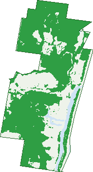
Green: 10 m cells where trees dominate, satellite 2021. Blue: water. The line is the suburb boundary.
| Canopy share, 1 m canopy height map, 2020 | 58.5% |
|---|---|
| Land with trees, 10 m satellite map, 2021 | 68.5% |
Demographics
Unemployment 4.5% · Labour-force participation 57.1%
Population by age in Pottsville
| 0-4 | 458 |
|---|---|
| 5-14 | 1,230 |
| 15-19 | 391 |
| 20-24 | 212 |
| 25-34 | 540 |
| 35-44 | 1,103 |
| 45-54 | 929 |
| 55-64 | 849 |
| 65-74 | 861 |
| 75-84 | 450 |
| 85+ | 193 |
Dwelling types in Pottsville
| House | 1,923 |
|---|---|
| Townhouse | 447 |
| Apartment | 104 |
| Other | 45 |
Households by weekly income in Pottsville
| <$650 | 398 |
|---|---|
| $650-1,499 | 748 |
| $1,500-2,999 | 781 |
| $3,000+ | 424 |
Top ancestries in Pottsville
| English | 3,295 |
|---|---|
| Australian | 2,734 |
| Irish | 1,057 |
| Scottish | 881 |
| Other | 487 |
| Ancestry NS | 484 |
Housing tenure in Pottsville
| Owned | 943 |
|---|---|
| Mortgage | 968 |
| Rented | 576 |
| Other | 19 |
Cars per household in Pottsville
| 0 | 57 |
|---|---|
| 1 | 836 |
| 2 | 1,190 |
| 3 | 296 |
| 4+ | 118 |
Commute to work in Pottsville
| Car | 1,945 |
|---|---|
| Train | 0 |
| Bus | 10 |
| Tram/ferry | 0 |
| Walked | 47 |
| Bicycle | 26 |
| Home | 503 |
Top countries of birth in Pottsville
| England | 367 |
|---|---|
| New Zealand | 172 |
| United States | 42 |
| Netherlands | 35 |
| Scotland | 35 |
| South Africa | 34 |
Languages used at home in Pottsville
| Japanese | 30 |
|---|---|
| Spanish | 24 |
| German | 22 |
| French | 20 |
| Thai | 16 |
| Portuguese | 15 |
Birds & Wildlife Nearby
38,838 bird observations recorded near Pottsville — most often seen:
- White-cheeked Honeyeater (3,067)
- Welcome Swallow (1,742)
- Noisy Friarbird (1,569)
- Masked Lapwing (1,542)
- Australian White Ibis (1,536)
- Crested Tern (1,534)
- Brown Honeyeater (1,514)
- Silver Gull (1,448)
- Scaly-breasted Lorikeet (1,409)
- Willie Wagtail (1,371)
- Noisy Miner (1,369)
- Lewin's Honeyeater (1,346)
- Australian Brush-turkey (1,331)
Show all 30 birds recorded near Pottsville
- Australian Magpie (1,285)
- Rainbow Lorikeet (1,271)
- Australasian Figbird (1,229)
- Australian Pied Oystercatcher (1,181)
- Torresian Crow (1,173)
- Pied Currawong (1,118)
- Eastern Spinebill (1,081)
- Magpie-lark (1,029)
- Laughing Kookaburra (1,025)
- Little Black Cormorant (1,015)
- Australian Pelican (1,014)
- Rainbow Bee-eater (975)
- Little Wattlebird (955)
- Bush Stone-curlew (951)
- Pacific Black Duck (931)
- Osprey (920)
- Crested Pigeon (907)
Sightings reported by observers, not a survey, so the counts show what people record rather than what lives here. Source: Atlas of Living Australia.
Nearby Suburbs
The closest suburbs to Pottsville:
- Hastings Point (3.5 km)
- Round Mountain (3.9 km)
- Cudgera Creek (4.1 km)
- Sleepy Hollow (5.3 km)
- Bogangar (6.1 km)
- Tanglewood (6.4 km)
- Cabarita Beach (6.6 km)
- Wooyung (7.3 km)
Embed this suburb
Add this free Pottsville stat card to your own site — just copy the code:
Preview:
Cite this page
Quoting these figures? Copy the credit line:
Keep an eye on Pottsville
One email when this data meaningfully changes — new census figures, prices, rankings. No spam, unsubscribe anytime.
Streets
- Andrew Avenue (93)
- Anne Street (14)
- Arrawarra Street (11)
- Ballina Street (81)
- Balmoral Street (29)
- Bandicoot Street (14)
- Banksia Avenue (8)
- Beatrice Court (11)
- Benaud Place (13)
- Berkleys Lane (1)
- Bonville Street (16)
- Border Crescent (76)
- Boronia Avenue (31)
- Bottlebrush Drive (33)
- Brushtail Court (13)
- Buckingham Drive (61)
- Bunya Crescent (5)
- Butternut Place (6)
- Camden Court (13)
- Carnarvon Court (9)
- Caroline Street (13)
- Centennial Drive (41)
- Chappell Place (11)
- Charles Street (1)
- Coffs Street (3)
- Corindi Street (10)
- Coronation Avenue (175)
- Coucal Street (8)
- Cudgera Avenue (15)
- Diana Court (17)
- Echidna Street (26)
- Edinburgh Court (44)
- Edward Avenue (63)
- Elanora Avenue (173)
- Elfran Avenue (25)
- Elizabeth Street (97)
- Endiandra Close (4)
- Environmental Drive (9)
- Euodia Avenue (19)
- Evans Street (6)
- Flintwood Street (20)
- Grey Gum Street (11)
- Hampton Court (70)
- Hassett Drive (23)
- Hazelwood Drive (21)
- Hibbertia Court (6)
- Hovea Drive (29)
- Iluka Court (10)
- Jagera Close (15)
- Kellehers Road (39)
- Kiama Street (4)
- Kippax Place (9)
- Korora Parkway (48)
- Lennox Circuit (122)
- Lindwall Avenue (14)
- Lomandra Avenue (34)
- Macadamia Drive (39)
- Marsupial Drive (61)
- Mckenzie Avenue (64)
- Melia Close (9)
- Miller Place (15)
- Monash Place (13)
- Moonee Street (13)
- Mountbatten Court (27)
- Mullaway Parade (14)
- Muskheart Circuit (40)
- Mylestom Circle (94)
- Nambucca Street (9)
- Narooma Street (26)
- Newcastle Drive (115)
- Nowra Street (6)
- O'reilly Place (14)
- Overall Drive (234)
- Paula Court (20)
- Peters Court (20)
- Philip Street (22)
- Ponsford Place (8)
- Pottsville Road (8)
- Rajungra Avenue (3)
- Roseash Court (13)
- Royal Drive (71)
- Sandon Court (6)
- Sarah Court (21)
- Sassafras Street (63)
- Sawtell Circuit (14)
- Seabrae Court (48)
- Seabreeze Boulevard (42)
- Silveraspen Grove (9)
- Suffolk Parade (30)
- Sugar Glider Drive (49)
- Surfside Crescent (37)
- Tallon Court (9)
- Taree Street (4)
- Tathra Street (13)
- Taylor Drive (30)
- Terrigal Street (24)
- Toormina Court (25)
- Toshack Place (11)
- Trumper Place (10)
- Tudor Court (15)
- Tweed Coast Road (345)
- Urunga Drive (41)
- Valla Street (8)
- Victoria Avenue (75)
- Warne Place (10)
- Watego Drive (14)
- Westminster Court (7)
- Windsor Court (10)
- Woodfull Crescent (24)
- Woolgoolga Court (16)
- Wooli Street (4)
- Yamba Street (10)