Pinny Beach NSW 2281
46 addresses · 5 streets
Shortland Electorate › Lake Macquarie LGA › Pinny Beach · 92 km from Sydney

Getting Around & Local Services
4 cafés & restaurants
3 supermarkets
1 Catholic church
1 pharmacy
1 physiotherapist
3 childcare & kindergartens
2 libraries
2 post offices
1 gym
2 golf clubs
Getting around. Airport: Lake Macquarie Airport, 5.8 km north.
Tree cover
🌳 Tree canopy: 80.9% share of land under canopy · satellite map, 2020
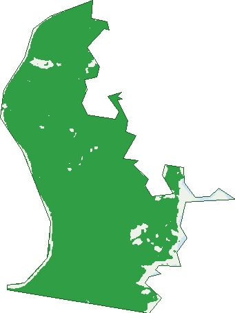
Green: 10 m cells where trees dominate, satellite 2021. Blue: water. The line is the suburb boundary.
| Canopy share, 1 m canopy height map, 2020 | 80.9% |
|---|---|
| Land with trees, 10 m satellite map, 2021 | 94.3% |
Birds & Wildlife Nearby
18,736 bird observations recorded near Pinny Beach — most often seen:
- Silver Gull (1,395)
- Rainbow Lorikeet (1,174)
- Little Pied Cormorant (942)
- Australian Magpie (924)
- Australian Pelican (907)
- Crested Tern (810)
- Noisy Miner (767)
- Australian Raven (732)
- Welcome Swallow (697)
- Little Wattlebird (677)
- White-faced Heron (649)
- Willie Wagtail (642)
- Pied Cormorant (625)
Show all 30 birds recorded near Pinny Beach
- Little Black Cormorant (610)
- Australian Wood Duck (589)
- White-bellied Sea-eagle (561)
- Laughing Kookaburra (523)
- Eastern Rainbow Lorikeet (482)
- Scaly-breasted Lorikeet (474)
- Masked Lapwing (464)
- Crested Pigeon (424)
- Lewin's Honeyeater (421)
- Superb Fairy-wren (421)
- Southern Lewin's Honeyeater (414)
- Spotted Turtle-dove (413)
- South-eastern Little Wattlebird (409)
- Magpie-lark (403)
- Great Cormorant (397)
- Eastern Australian Raven (395)
- South-eastern Yellow-faced Honeyeater (395)
Sightings reported by observers, not a survey, so the counts show what people record rather than what lives here. Source: Atlas of Living Australia.
Nearby Suburbs
The closest suburbs to Pinny Beach:
- Murrays Beach (1.2 km)
- Cams Wharf (1.5 km)
- Caves Beach (1.6 km)
- Swansea (3.2 km)
- Nords Wharf (3.4 km)
- Swansea Heads (3.4 km)
- Little Pelican (4.2 km)
- Blacksmiths (4.7 km)
Embed this suburb
Add this free Pinny Beach stat card to your own site — just copy the code:
Preview:
Cite this page
Quoting these figures? Copy the credit line:
Keep an eye on Pinny Beach
One email when this data meaningfully changes — new census figures, prices, rankings. No spam, unsubscribe anytime.
Streets
- Copper Valley Close (1)
- Mine Camp Road (10)
- Old Pacific Highway (14)
- Pacific Highway (14)
- Scenic Drive (7)