Paddington NSW 2021
8,782 addresses · 133 streets
Wentworth Electorate › Woollahra LGA › Paddington · 2 km from Sydney
📦 Thinking of moving here? Read the Paddington moving guide

Living Here
An affluent eastern-Sydney suburb famous for its Victorian terraces, galleries and Oxford Street, Paddington is highly sought-after. Households average 2.1 people and the median age is 38. Median household income is very high at $3,131 a week, with rent around $650.
Paddington is a suburb of New South Wales, home to about 12,701 people, with a median age of 38. The typical household earns around $3,131 a week, with median rent near $650 a week. Most homes are townhouses. About 53% of households own their home and 45% rent. Most workers work from home. Common community backgrounds include English, Australian, Irish. On the ABS socio-economic scale it sits in decile 10 of 10 nationally — a relatively advantaged area.
Over time — Census 2001 → 2021
Dashed line: district figures for the Paddington - Moore Park statistical area (SA2), the smallest area the ABS published before 2011. Solid line: Paddington itself.
Getting Around & Local Services
27 childcare & kindergartens
2 carpenters
Getting around. Train station: Edgecliff, 900 m north-east · Metro station: Central, 2 km west · Light rail stop: Moore Park, 1.2 km south-west · Bus interchange: Bondi Junction Interchange, 2.1 km south-east · Ferry wharf: Double Bay, 1.8 km north-east · Airport: Rose Bay Seaplane Base, 3.6 km north-east.
Socio-economic Standing
Deciles from 1 (lowest) to 10 (highest), against all Australian suburbs. The overall figure weighs advantage and disadvantage together; economic resources counts income and housing, and education & jobs counts qualifications and occupation. They often differ. Source: ABS SEIFA 2021.
Tree cover
🌳 Tree canopy: 15.7% share of land under canopy · satellite map, 2020
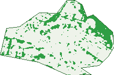
Green: 10 m cells where trees dominate, satellite 2021. Blue: water. The line is the suburb boundary.
| Canopy share, 1 m canopy height map, 2020 | 15.7% |
|---|---|
| Land with trees, 10 m satellite map, 2021 | 15.3% |
Demographics
Unemployment 3.7% · Labour-force participation 72.2%
Population by age in Paddington
| 0-4 | 601 |
|---|---|
| 5-14 | 1,061 |
| 15-19 | 440 |
| 20-24 | 790 |
| 25-34 | 2,762 |
| 35-44 | 2,037 |
| 45-54 | 1,735 |
| 55-64 | 1,330 |
| 65-74 | 1,027 |
| 75-84 | 676 |
| 85+ | 236 |
Dwelling types in Paddington
| House | 361 |
|---|---|
| Townhouse | 3,325 |
| Apartment | 1,749 |
| Other | 55 |
Households by weekly income in Paddington
| <$650 | 526 |
|---|---|
| $650-1,499 | 854 |
| $1,500-2,999 | 1,146 |
| $3,000+ | 2,683 |
Top ancestries in Paddington
| English | 5,141 |
|---|---|
| Australian | 3,397 |
| Irish | 2,134 |
| Other | 1,768 |
| Scottish | 1,626 |
| Ancestry NS | 657 |
Housing tenure in Paddington
| Owned | 1,489 |
|---|---|
| Mortgage | 1,400 |
| Rented | 2,452 |
| Other | 105 |
Cars per household in Paddington
| 0 | 1,157 |
|---|---|
| 1 | 2,911 |
| 2 | 1,095 |
| 3 | 188 |
| 4+ | 74 |
Commute to work in Paddington
| Car | 1,110 |
|---|---|
| Train | 76 |
| Bus | 238 |
| Tram/ferry | 0 |
| Walked | 589 |
| Bicycle | 89 |
| Home | 4,678 |
Top countries of birth in Paddington
| England | 1,012 |
|---|---|
| New Zealand | 444 |
| United States | 264 |
| South Africa | 158 |
| France | 114 |
| Ireland | 104 |
Languages used at home in Paddington
| French | 175 |
|---|---|
| Spanish | 155 |
| Greek | 129 |
| Italian | 125 |
| Mandarin | 95 |
| Cantonese | 92 |
Birds & Wildlife Nearby
342,626 bird observations recorded near Paddington — most often seen:
- Rainbow Lorikeet (27,721)
- Australian White Ibis (24,931)
- Noisy Miner (22,908)
- Rock Dove (18,562)
- Silver Gull (17,371)
- Australian Magpie (14,689)
- Welcome Swallow (14,036)
- Common Myna (13,947)
- Pied Currawong (13,296)
- Dusky Moorhen (12,809)
- Sulphur-crested Cockatoo (12,559)
- Australian Raven (12,013)
- Pacific Black Duck (11,823)
Show all 30 birds recorded near Paddington
- Magpie-lark (10,312)
- Laughing Kookaburra (9,754)
- Little Black Cormorant (9,403)
- Masked Lapwing (9,185)
- Crested Pigeon (8,496)
- Australian Wood Duck (7,574)
- Little Pied Cormorant (7,336)
- Black Swan (7,246)
- Australasian Purple Swamphen (7,097)
- Eurasian Coot (7,025)
- Pied Cormorant (6,701)
- Willie Wagtail (6,679)
- Grey Butcherbird (6,021)
- Little Corella (5,927)
- Spotted Turtle-dove (5,922)
- Superb Fairy-wren (5,657)
- Australasian Darter (5,626)
Sightings reported by observers, not a survey, so the counts show what people record rather than what lives here. Source: Atlas of Living Australia.
Nearby Suburbs
The closest suburbs to Paddington:
- Edgecliff (0.9 km)
- Centennial Park (1 km)
- Rushcutters Bay (1 km)
- Darlinghurst (1.1 km)
- Moore Park (1.2 km)
- Woollahra (1.3 km)
- Potts Point (1.4 km)
- Elizabeth Bay (1.4 km)
Embed this suburb
Add this free Paddington stat card to your own site — just copy the code:
Preview:
Cite this page
Quoting these figures? Copy the credit line:
Keep an eye on Paddington
One email when this data meaningfully changes — new census figures, prices, rankings. No spam, unsubscribe anytime.
Streets
- Albert Square (10)
- Albert Street (2)
- Albion Avenue (54)
- Albion Lane (1)
- Alexander Street (19)
- Alma Street (16)
- Barcom Avenue (4)
- Bates Avenue (36)
- Begg Lane (2)
- Bellevue Avenue (4)
- Belmore Place (5)
- Bennetts Grove Avenue (37)
- Bent Street (55)
- Boundary Street (139)
- Bourke Lane (1)
- Brodie Street (93)
- Broughton Street (23)
- Brown Street (143)
- Caledonia Street (92)
- Cambridge Lane (8)
- Cambridge Street (69)
- Campbell Avenue (78)
- Cascade Street (154)
- Cecil Street (83)
- Church Place (8)
- Church Street (20)
- Comber Street (63)
- Cooper Street (75)
- Dillon Street (61)
- Dudley Street (42)
- Duxford Street (89)
- Elfred Street (17)
- Elizabeth Place (11)
- Elizabeth Street (109)
- Flinders Street (97)
- Flinton Street (200)
- Forbes Street (5)
- George Street (43)
- Gipps Street (58)
- Glen Street (74)
- Glenmore Road (632)
- Glenview Lane (1)
- Glenview Street (103)
- Goodhope Street (88)
- Gordon Street (79)
- Gosbell Street (44)
- Greens Road (38)
- Gurner Street (73)
- Hampden Street (170)
- Hargrave Lane (27)
- Hargrave Street (250)
- Harris Street (59)
- Heeley Street (75)
- Hoddle Street (26)
- Hopetoun Street (52)
- Hopewell Lane (4)
- Hopewell Street (192)
- Iris Street (47)
- Jersey Road (205)
- Josephson Street (6)
- Kidman Lane (5)
- Lawson Street (108)
- Leinster Street (72)
- Little Comber Street (32)
- Little Dowling Street (8)
- Little Napier Street (21)
- Little Selwyn Street (10)
- Little Stewart Street (4)
- Liverpool Street (120)
- Macdonald Street (64)
- Margaret Place (3)
- Martin Street (12)
- Mary Place (17)
- Mcgarvie Street (21)
- Mclaughlan Place (2)
- Moore Park Road (449)
- Napier Street (36)
- Neild Avenue (21)
- New South Head Road (3)
- Newcombe Street (4)
- Norfolk Street (42)
- Oatley Road (116)
- Olive Street (19)
- Ormond Street (85)
- Oxford Street (692)
- Paddington Lane (7)
- Paddington Street (189)
- Prospect Street (31)
- Quarry Street (5)
- Queen Road (25)
- Regent Lane (1)
- Regent Street (101)
- Renny Lane (19)
- Renny Street (44)
- Rose Terrace (19)
- Roylston Lane (6)
- Roylston Street (48)
- Selwyn Street (95)
- Seymour Place (17)
- Shadforth Street (16)
- Short Street (4)
- Soudan Lane (4)
- Soudan Street (1)
- South Dowling Street (71)
- Spring Street (13)
- Stafford Street (61)
- Stephen Street (141)
- Stewart Place (6)
- Stewart Street (105)
- Suffolk Street (42)
- Sutherland Avenue (25)
- Sutherland Street (358)
- Taylor Street (8)
- Tivoli Street (9)
- Ulster Street (3)
- Underwood Lane (1)
- Underwood Street (406)
- Union Lane (1)
- Union Street (45)
- Verona Street (49)
- Vialoux Avenue (23)
- Victoria Place (15)
- Victoria Street (47)
- Walker Lane (1)
- Walter Street (42)
- Watson Street (14)
- Weedon Avenue (2)
- Wentworth Street (23)
- West Street (30)
- William Street (87)
- Windsor Lane (3)
- Windsor Street (197)
- Young Street (85)