Ourimbah NSW 2258
1,982 addresses · 87 streets
Dobell Electorate › Central Coast LGA › Ourimbah · 59 km from Sydney
📦 Thinking of moving here? Read the Ourimbah moving guide

Living Here
Ourimbah is a suburb of New South Wales, home to about 4,019 people, with a median age of 39. The typical household earns around $1,940 a week, with median rent near $400 a week. Most homes are houses. About 76% of households own their home and 23% rent. Most workers drive to work. Common community backgrounds include English, Australian, Irish. On the ABS socio-economic scale it sits in decile 7 of 10 nationally — a mid-range area.
Over time — Census 2001 → 2021
Dashed line: district figures for the Ourimbah - Fountaindale statistical area (SA2), the smallest area the ABS published before 2011. Solid line: Ourimbah itself.
Getting Around & Local Services
1 supermarket
2 pharmacies
3 doctors & medical clinics
1 dentist
2 physiotherapists
2 childcare & kindergartens
1 post office
5 service stations
4 gyms & sports centres
2 golf clubs
1 dog park
1 hardware store
3 hairdressers
1 mechanic
1 electrician
3 places to stay
Getting around. Train station: Ourimbah, 150 m west · Airport: Somersby Airfield, 6.7 km west.
Socio-economic Standing
Deciles from 1 (lowest) to 10 (highest), against all Australian suburbs. The overall figure weighs advantage and disadvantage together; economic resources counts income and housing, and education & jobs counts qualifications and occupation. They often differ. Source: ABS SEIFA 2021.
Tree cover
🌳 Tree canopy: 91.2% share of land under canopy · satellite map, 2020
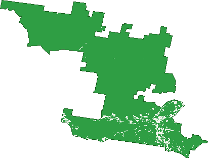
Green: 10 m cells where trees dominate, satellite 2021. Blue: water. The line is the suburb boundary.
| Canopy share, 1 m canopy height map, 2020 | 91.2% |
|---|---|
| Land with trees, 10 m satellite map, 2021 | 96.5% |
Demographics
Unemployment 2.9% · Labour-force participation 66.3%
Population by age in Ourimbah
| 0-4 | 227 |
|---|---|
| 5-14 | 517 |
| 15-19 | 286 |
| 20-24 | 247 |
| 25-34 | 503 |
| 35-44 | 537 |
| 45-54 | 552 |
| 55-64 | 574 |
| 65-74 | 347 |
| 75-84 | 171 |
| 85+ | 54 |
Dwelling types in Ourimbah
| House | 1,081 |
|---|---|
| Townhouse | 323 |
| Apartment | 7 |
| Other | 0 |
Households by weekly income in Ourimbah
| <$650 | 180 |
|---|---|
| $650-1,499 | 333 |
| $1,500-2,999 | 491 |
| $3,000+ | 346 |
Top ancestries in Ourimbah
| English | 1,836 |
|---|---|
| Australian | 1,653 |
| Irish | 502 |
| Scottish | 483 |
| Other | 267 |
| Ancestry NS | 160 |
Housing tenure in Ourimbah
| Owned | 450 |
|---|---|
| Mortgage | 610 |
| Rented | 328 |
| Other | 14 |
Cars per household in Ourimbah
| 0 | 28 |
|---|---|
| 1 | 428 |
| 2 | 584 |
| 3 | 201 |
| 4+ | 160 |
Commute to work in Ourimbah
| Car | 1,111 |
|---|---|
| Train | 22 |
| Bus | 6 |
| Tram/ferry | 0 |
| Walked | 18 |
| Bicycle | 0 |
| Home | 522 |
Top countries of birth in Ourimbah
| England | 185 |
|---|---|
| New Zealand | 76 |
| China | 34 |
| Philippines | 33 |
| Germany | 23 |
| South Africa | 23 |
Languages used at home in Ourimbah
| Mandarin | 42 |
|---|---|
| Spanish | 24 |
| Cantonese | 21 |
| German | 20 |
| Filipino | 17 |
| Vietnamese | 16 |
Birds & Wildlife Nearby
41,477 bird observations recorded near Ourimbah — most often seen:
- Lewin's Honeyeater (2,812)
- Bell Miner (2,376)
- Eastern Yellow Robin (2,304)
- Eastern Whipbird (1,958)
- Laughing Kookaburra (1,904)
- Superb Fairy-wren (1,826)
- Grey Fantail (1,776)
- Rainbow Lorikeet (1,737)
- Brown Gerygone (1,717)
- Red-browed Finch (1,632)
- Sulphur-crested Cockatoo (1,288)
- Eastern Spinebill (1,280)
- Australian Magpie (1,270)
Show all 30 birds recorded near Ourimbah
- Silvereye (1,227)
- White-browed Scrubwren (1,224)
- Yellow-throated Scrubwren (1,221)
- Brown Thornbill (1,218)
- Green Catbird (1,210)
- Red-whiskered Bulbul (1,205)
- Regent Bowerbird (1,097)
- Black-faced Monarch (1,088)
- Australian Brush-turkey (1,013)
- Satin Bowerbird (979)
- Wonga Pigeon (943)
- Brown Cuckoo-dove (937)
- Topknot Pigeon (920)
- Pied Currawong (908)
- Southern Lewin's Honeyeater (835)
- Yellow-faced Honeyeater (803)
- Australian King-parrot (769)
Sightings reported by observers, not a survey, so the counts show what people record rather than what lives here. Source: Atlas of Living Australia.
Nearby Suburbs
The closest suburbs to Ourimbah:
- Lisarow (2.6 km)
- Niagara Park (3.1 km)
- Fountaindale (3.3 km)
- Palmdale (3.3 km)
- Kangy Angy (4.5 km)
- Mount Elliot (5 km)
- Narara (5.1 km)
- Wyoming (5.3 km)
Embed this suburb
Add this free Ourimbah stat card to your own site — just copy the code:
Preview:
Cite this page
Quoting these figures? Copy the credit line:
Keep an eye on Ourimbah
One email when this data meaningfully changes — new census figures, prices, rankings. No spam, unsubscribe anytime.
Streets
- Acorn Place (17)
- Albert Street (58)
- Alex Close (71)
- Ann Close (13)
- Baileys Road (6)
- Bangalore Street (10)
- Bangalow Creek Lane (4)
- Beans Place (1)
- Beckford Road (11)
- Beechwood Street (48)
- Bloodwood Close (7)
- Bluegum Lane (2)
- Boxwood Close (9)
- Bridge Street (9)
- Bristowe Close (10)
- Brownlee Street (3)
- Brush Road (42)
- Bullock Road (42)
- Bumbles Creek Road (5)
- Burns Road (109)
- Cambridge Circle (45)
- Casula Place (16)
- Charles Street (9)
- Chittaway Road (28)
- Coachwood Drive (85)
- Coraki Close (49)
- Cutrock Road (8)
- Dianella Street (15)
- Dog Trap Road (86)
- Edson Avenue (15)
- Edye Road (1)
- Elmo Street (7)
- Enterprise Drive (2)
- Fern Road (25)
- Finlay Crescent (43)
- Fitton Close (7)
- Footts Road (14)
- Frederick Street (8)
- Glen Road (55)
- Highfields Grove (6)
- Hillgrove Close (38)
- Howes Road (8)
- Ironbark Close (20)
- James Graham Lane (5)
- Jaques Street (22)
- Jarrah Court (12)
- Kadija Close (1)
- Kauri Court (27)
- Kilkenny Road (3)
- King Street (39)
- Knight Close (16)
- Lara Close (13)
- Leeder Road (15)
- Little Brush Lane (3)
- Logan Place (4)
- Louise Close (5)
- Mahogany Close (10)
- Mary Jane Street (1)
- Natasha Close (1)
- Nellie Road (11)
- Oak Road (2)
- Old Dog Trap Road (3)
- Old Farm Place (31)
- Ourimbah Creek Road (69)
- Ourimbah Street (7)
- Pacific Highway (208)
- Peach Orchard Road (11)
- Penny Place (11)
- Peppermint Close (11)
- Pryor Road (13)
- Red Cedar Close (25)
- Reservoir Road (21)
- Robert Holl Drive (51)
- Rosewood Close (16)
- Schubolt Lane (2)
- Shirley Street (79)
- Station Street (10)
- Sydney Newcastle Freeway (2)
- Tallowood Crescent (44)
- Teralba Street (7)
- Timber Road (1)
- Turners Way (1)
- Turpentine Road (2)
- Walmsley Road (60)
- Whistle Hill Lane (2)
- Yates Road (35)
- Youngs Road (3)