Oberon NSW 2787
2,550 addresses · 127 streets
Calare Electorate › Oberon LGA › Oberon · 126 km from Sydney
📦 Thinking of moving here? Read the Oberon moving guide

Living Here
Oberon is a suburb of New South Wales, home to about 3,319 people, with a median age of 47. The typical household earns around $1,321 a week, with median rent near $280 a week. Most homes are houses. About 70% of households own their home and 28% rent. Most workers drive to work. Common community backgrounds include Australian, English, Irish. On the ABS socio-economic scale it sits in decile 2 of 10 nationally — a more disadvantaged area.
Over time — Census 2001 → 2021
Dashed line: district figures for the Oberon statistical area (SA2), the smallest area the ABS published before 2011. Solid line: Oberon itself.
Getting Around & Local Services
2 supermarkets
1 pharmacy
1 medical clinic
1 hospital
1 childcare centre
1 library
1 post office
4 service stations
3 gyms & sports centres
1 golf club
1 playground
2 bakeries
2 butchers
1 hardware store
3 hairdressers
1 beauty salon
1 plumber
Getting around. Airport: Bathurst Airport, 37.7 km north-west.
Socio-economic Standing
Deciles from 1 (lowest) to 10 (highest), against all Australian suburbs. The overall figure weighs advantage and disadvantage together; economic resources counts income and housing, and education & jobs counts qualifications and occupation. They often differ. Source: ABS SEIFA 2021.
Tree cover
🌳 Tree canopy: 23.6% share of land under canopy · satellite map, 2020
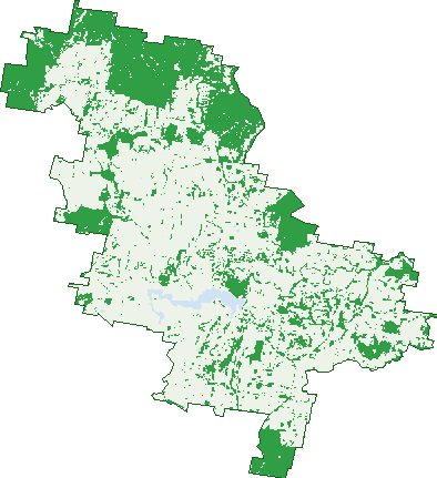
Green: 10 m cells where trees dominate, satellite 2021. Blue: water. The line is the suburb boundary.
| Canopy share, 1 m canopy height map, 2020 | 23.6% |
|---|---|
| Land with trees, 10 m satellite map, 2021 | 31.1% |
Demographics
Unemployment 4.4% · Labour-force participation 53.8%
Population by age in Oberon
| 0-4 | 154 |
|---|---|
| 5-14 | 422 |
| 15-19 | 176 |
| 20-24 | 149 |
| 25-34 | 341 |
| 35-44 | 346 |
| 45-54 | 396 |
| 55-64 | 464 |
| 65-74 | 483 |
| 75-84 | 296 |
| 85+ | 89 |
Dwelling types in Oberon
| House | 1,171 |
|---|---|
| Townhouse | 82 |
| Apartment | 26 |
| Other | 10 |
Households by weekly income in Oberon
| <$650 | 276 |
|---|---|
| $650-1,499 | 386 |
| $1,500-2,999 | 371 |
| $3,000+ | 156 |
Top ancestries in Oberon
| Australian | 1,308 |
|---|---|
| English | 1,297 |
| Irish | 446 |
| Ancestry NS | 354 |
| Scottish | 295 |
| Other | 214 |
Housing tenure in Oberon
| Owned | 523 |
|---|---|
| Mortgage | 368 |
| Rented | 350 |
| Other | 26 |
Cars per household in Oberon
| 0 | 62 |
|---|---|
| 1 | 446 |
| 2 | 492 |
| 3 | 172 |
| 4+ | 99 |
Commute to work in Oberon
| Car | 1,040 |
|---|---|
| Train | 0 |
| Bus | 5 |
| Tram/ferry | 0 |
| Walked | 61 |
| Bicycle | 3 |
| Home | 111 |
Top countries of birth in Oberon
| England | 78 |
|---|---|
| New Zealand | 52 |
| India | 26 |
| South Africa | 24 |
| Fiji | 21 |
| Germany | 15 |
Languages used at home in Oberon
| Malayalam | 16 |
|---|---|
| Greek | 13 |
| Nepali | 12 |
| Khmer | 12 |
| Afrikaans | 11 |
| Serbian | 10 |
Birds & Wildlife Nearby
4,130 bird observations recorded near Oberon — most often seen:
- Sulphur-crested Cockatoo (1,057)
- Australian Magpie (283)
- Grey Fantail (273)
- Crimson Rosella (229)
- Yellow-tailed Black-cockatoo (200)
- Pied Currawong (155)
- Australian King-parrot (146)
- Galah (138)
- White-throated Treecreeper (138)
- Laughing Kookaburra (130)
- Pacific Black Duck (122)
- Australian Wood Duck (118)
- Red Wattlebird (99)
Show all 30 birds recorded near Oberon
- Australian Raven (96)
- Common Starling (95)
- Magpie-lark (89)
- Eurasian Coot (83)
- Superb Fairy-wren (77)
- Welcome Swallow (71)
- Brown Thornbill (54)
- Little Raven (54)
- Masked Lapwing (54)
- Willie Wagtail (52)
- Yellow-faced Honeyeater (50)
- Black-faced Cuckoo-shrike (48)
- Yellow-rumped Thornbill (48)
- White-faced Heron (46)
- Great Crested Grebe (43)
- House Sparrow (42)
- Eastern Rosella (40)
Sightings reported by observers, not a survey, so the counts show what people record rather than what lives here. Source: Atlas of Living Australia.
Nearby Suburbs
The closest suburbs to Oberon:
- Hazelgrove (6.6 km)
- Norway (8.9 km)
- Duckmaloi (8.9 km)
- Mayfield (9.6 km)
- The Meadows (9.7 km)
- Edith (10.8 km)
- Twenty Forests (11.6 km)
- Mozart (13 km)
Embed this suburb
Add this free Oberon stat card to your own site — just copy the code:
Preview:
Cite this page
Quoting these figures? Copy the credit line:
Keep an eye on Oberon
One email when this data meaningfully changes — new census figures, prices, rankings. No spam, unsubscribe anytime.
Streets
- Abercrombie Road (32)
- Albert Street (23)
- Albion Street (93)
- Armstrong Place (7)
- Baileys Lane (15)
- Balfour Street (72)
- Beattie Road (10)
- Bell Street (5)
- Ben Nevis Close (5)
- Black Bullock Road (11)
- Blenheim Avenue (46)
- Bligh Street (41)
- Bounty Street (1)
- Bracken Glen Lane (5)
- Brennan Crescent (31)
- Brien Road (1)
- Briens Road (1)
- Buckley Crescent (14)
- Butterfactory Lane (8)
- Carrington Avenue (62)
- Chatham Valley Road (12)
- Clover Lane (5)
- Cole Crescent (4)
- Colley Close (6)
- Cook Street (8)
- Crete Street (1)
- Cunynghame Street (38)
- Curtis Street (75)
- Dart Street (101)
- Dickson Close (8)
- Dillon Street (20)
- Doctor Perkins Crescent (19)
- Duckmaloi Road (56)
- Dudley Street (29)
- Dulce Drive (17)
- Earl Street (11)
- Eaton Lane (3)
- Edith Road (35)
- Ellis Drive (38)
- Endeavour Street (15)
- Fairfax Street (7)
- Fairview Drive (6)
- Faugha Ballaugha Road (11)
- Fawcett Road (2)
- Ferndale Road (9)
- Fleming Street (18)
- Fox Crescent (3)
- Fox Lane (9)
- Gilholmes Road (5)
- Glendalough Road (9)
- Glyndwr Avenue (31)
- Harris Road (13)
- Harveys Road (15)
- Hawken Street (9)
- Hawkes Drive (28)
- Hazelgrove Road (25)
- Herborn Street (19)
- Highland Road (2)
- Hollis Lane (1)
- Homeward Bound Avenue (5)
- Horace Street (13)
- Howards Lane (3)
- Humphries Drive (8)
- Hunter Street (3)
- Inverness Place (9)
- Jaunter Road (2)
- Jenolan Caves Road (4)
- Jenolan Street (42)
- Kelly Place (9)
- Kellys Lane (3)
- King Street (5)
- Links Close (13)
- Lowes Mount Road (78)
- Luchetti Place (7)
- Lysander Road (11)
- Maher Drive (10)
- Marks Crescent (20)
- Mayfield Road (8)
- Mchattan Close (16)
- Mcmahon Court (4)
- Midsummer Avenue (3)
- Moray Close (9)
- Mount Norway Road (2)
- Mozart Road (3)
- Muirs Road (8)
- North Street (89)
- Nurse Fox Close (3)
- O'connell Road (79)
- Oberon Street (197)
- On-avon Avenue (14)
- Parkes Street (5)
- Phillip Street (7)
- Pilarcik Lane (5)
- Prince Street (3)
- Queen Street (116)
- Raleigh Street (10)
- Ramsgate Lane (2)
- Ross Street (56)
- Rupert Street (13)
- Rutters Ridge (39)
- Scotia Avenue (74)
- Scott Close (7)
- Sewells Creek Road (4)
- Shakespeare Close (18)
- Shooters Hill Road (19)
- Sirius Street (9)
- Soldiers Hill Road (3)
- Spicer Place (8)
- Spring Valley Road (3)
- Springfield Street (68)
- Springmount Road (1)
- Stevenson Close (13)
- Strathroy Avenue (14)
- Tallys Lane (1)
- Tarana Crescent (23)
- Tarana Road (31)
- Tasman Street (22)
- The Reef Road (15)
- Throsby Way (1)
- Tiger Place (5)
- Titania Road (23)
- Warrina Avenue (5)
- Whalans Lane (3)
- Whiteley Lane (2)
- Whiteley Road (16)
- Whittakers Lane (1)
- Wilson Drive (19)