North Strathfield NSW 2137
2,727 addresses · 33 streets
Reid Electorate › Canada Bay LGA › North Strathfield · 11 km from Sydney
📦 Thinking of moving here? Read the North Strathfield moving guide

Living Here
North Strathfield is a suburb of New South Wales, home to about 4,618 people, with a median age of 34. The typical household earns around $2,333 a week, with median rent near $495 a week. Most homes are apartments. About 49% of households own their home and 49% rent. Most workers work from home. Common community backgrounds include Chinese, Australian, English. On the ABS socio-economic scale it sits in decile 10 of 10 nationally — a relatively advantaged area.
Over time — Census 2001 → 2021
Dashed line: district figures for the Concord West - North Strathfield statistical area (SA2), the smallest area the ABS published before 2011. Solid line: North Strathfield itself.
Getting Around & Local Services
71 schools
38 Catholic churches
11 doctors & medical clinics
- Aiya Medical Centre
- Homebush Medical and Dental Centre
- Homebush Health Clinic
- St. John of God
- St. John of God Medical Centre (Psychiatric)
- St. John of God
- Skin Clinic
- Total Care Health Strathfield
- Victoria Tower Medical
- Burwood Medical Centre
See all 11 doctors & medical clinics near North Strathfield →
15 childcare & kindergartens
- Kinda-Mindi Early Learning Centre
- Strathfield Preschool
- Woodstock Child Care
- Mini Masterminds
- Koala Kids
- Homebush West (Kurralee) Christian Early Learning Centre
- Burwood Montessori Academy
- Active Kids Homebush
- Active Kids Homebush
- Montessori Academy
See all 15 childcare & kindergartens near North Strathfield →
4 bakeries
2 butchers
5 beauty salons
2 carpenters
Getting around. Train station: North Strathfield, 250 m south · Metro station: Campsie, 6.1 km south · Bus interchange: STA Ryde Depot, 5.4 km north-east · Ferry wharf: Kissing Point, 3.1 km north-east · Airport: Bankstown Airport, 11.5 km south-west.
Socio-economic Standing
Deciles from 1 (lowest) to 10 (highest), against all Australian suburbs. The overall figure weighs advantage and disadvantage together; economic resources counts income and housing, and education & jobs counts qualifications and occupation. They often differ. Source: ABS SEIFA 2021.
Tree cover
🌳 Tree canopy: 10.6% share of land under canopy · satellite map, 2020
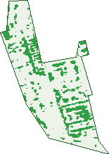
Green: 10 m cells where trees dominate, satellite 2021. Blue: water. The line is the suburb boundary.
| Canopy share, 1 m canopy height map, 2020 | 10.6% |
|---|---|
| Surveyed canopy, Greater Sydney aerial survey, 2019 | 14.6% |
| Land with trees, 10 m satellite map, 2021 | 15.4% |
Demographics
Unemployment 5.4% · Labour-force participation 68.4%
Population by age in North Strathfield
| 0-4 | 282 |
|---|---|
| 5-14 | 483 |
| 15-19 | 200 |
| 20-24 | 451 |
| 25-34 | 988 |
| 35-44 | 761 |
| 45-54 | 583 |
| 55-64 | 432 |
| 65-74 | 233 |
| 75-84 | 133 |
| 85+ | 64 |
Dwelling types in North Strathfield
| House | 555 |
|---|---|
| Townhouse | 135 |
| Apartment | 897 |
| Other | 31 |
Households by weekly income in North Strathfield
| <$650 | 168 |
|---|---|
| $650-1,499 | 294 |
| $1,500-2,999 | 517 |
| $3,000+ | 552 |
Top ancestries in North Strathfield
| Chinese | 969 |
|---|---|
| Other | 888 |
| Australian | 686 |
| English | 566 |
| Italian | 378 |
| Korean | 349 |
Housing tenure in North Strathfield
| Owned | 371 |
|---|---|
| Mortgage | 425 |
| Rented | 793 |
| Other | 20 |
Cars per household in North Strathfield
| 0 | 186 |
|---|---|
| 1 | 773 |
| 2 | 499 |
| 3 | 102 |
| 4+ | 42 |
Commute to work in North Strathfield
| Car | 731 |
|---|---|
| Train | 182 |
| Bus | 14 |
| Tram/ferry | 0 |
| Walked | 50 |
| Bicycle | 10 |
| Home | 1,039 |
Top countries of birth in North Strathfield
| China | 417 |
|---|---|
| India | 288 |
| South Korea | 280 |
| Nepal | 145 |
| Philippines | 132 |
| Hong Kong | 78 |
Languages used at home in North Strathfield
| Mandarin | 448 |
|---|---|
| Korean | 323 |
| Cantonese | 286 |
| Nepali | 145 |
| Italian | 137 |
| Hindi | 99 |
Birds & Wildlife Nearby
248,149 bird observations recorded near North Strathfield — most often seen:
- Australian White Ibis (16,189)
- Noisy Miner (14,765)
- Superb Fairy-wren (13,769)
- Rainbow Lorikeet (12,637)
- Australian Raven (12,507)
- Welcome Swallow (11,642)
- Silver Gull (11,386)
- Chestnut Teal (10,365)
- Australian Magpie (9,784)
- Pied Currawong (9,456)
- Dusky Moorhen (9,023)
- Magpie-lark (8,454)
- Masked Lapwing (8,132)
Show all 30 birds recorded near North Strathfield
- Common Myna (8,113)
- White-faced Heron (7,956)
- Pacific Black Duck (7,638)
- Willie Wagtail (7,180)
- Eurasian Coot (6,982)
- Little Pied Cormorant (6,167)
- Grey Teal (6,136)
- Australian Pelican (5,673)
- Red Wattlebird (5,644)
- Black Swan (5,612)
- Little Black Cormorant (5,318)
- Grey Butcherbird (5,164)
- Crested Pigeon (4,606)
- Australasian Purple Swamphen (4,595)
- Great Egret (4,552)
- Australasian Grebe (4,374)
- Rock Dove (4,330)
Sightings reported by observers, not a survey, so the counts show what people record rather than what lives here. Source: Atlas of Living Australia.
Nearby Suburbs
The closest suburbs to North Strathfield:
- Homebush (1 km)
- Concord West (1.2 km)
- Concord (1.6 km)
- Liberty Grove (1.9 km)
- Sydney Olympic Park (2 km)
- Strathfield (2.1 km)
- Homebush West (2.2 km)
- Mortlake (2.4 km)
Embed this suburb
Add this free North Strathfield stat card to your own site — just copy the code:
Preview:
Cite this page
Quoting these figures? Copy the credit line:
Keep an eye on North Strathfield
One email when this data meaningfully changes — new census figures, prices, rankings. No spam, unsubscribe anytime.
Streets
- Addy Lane (1)
- Allen Street (3)
- Argonne Street (18)
- Beronga Street (55)
- Brussels Street (21)
- Carrington Street (42)
- Concord Lane (4)
- Concord Road (266)
- Conway Avenue (23)
- Correys Avenue (2)
- Elliott Street (11)
- George Street (1,402)
- Gracemere Street (14)
- Hamilton Street (102)
- Lemnos Street (17)
- Lorraine Street (23)
- Malta Street (23)
- Mena Street (20)
- Napier Street (88)
- Nelson Road (39)
- Parramatta Road (51)
- Pomeroy Street (25)
- Princess Avenue (63)
- Queen Street (120)
- Railway Street (4)
- Rothwell Avenue (7)
- Shipley Avenue (63)
- Sydney Street (30)
- Tenterfield Street (17)
- Waratah Street (64)
- Warsaw Street (26)
- Wellbank Street (71)
- Young Street (12)