Newtown NSW 2042
10,732 addresses · 122 streets
Sydney Electorate › Inner West LGA › Newtown · 4 km from Sydney
📦 Thinking of moving here? Read the Newtown moving guide

Living Here
A vibrant inner-western Sydney suburb famous for King Street's eclectic shops and dining, Newtown is creative and apartment-rich. Households average 2.1 people and the median age is 34. Median household income is $2,330 a week, with rent around $550.
Newtown is a suburb of New South Wales, home to about 14,690 people, with a median age of 34. The typical household earns around $2,330 a week, with median rent near $550 a week. Most homes are townhouses. About 41% of households own their home and 58% rent. Most workers work from home. Common community backgrounds include English, Australian, Irish. On the ABS socio-economic scale it sits in decile 10 of 10 nationally — a relatively advantaged area.
Over time — Census 2001 → 2021
Dashed line: district figures for the Newtown - Camperdown - Darlington statistical area (SA2), the smallest area the ABS published before 2011. Solid line: Newtown itself.
Getting Around & Local Services
60 Catholic churches
33 childcare & kindergartens
2 carpenters
Getting around. Train station: Newtown, 50 m north-west · Metro station: Waterloo, 1.9 km east · Light rail stop: Glebe, 2.4 km north · Bus interchange: Mount St (501), 3.4 km north · Ferry wharf: Blackwattle Bay Wharf, 3 km north · Airport: Sydney (Kingsford Smith) Airport, 5.4 km south.
Socio-economic Standing
Deciles from 1 (lowest) to 10 (highest), against all Australian suburbs. The overall figure weighs advantage and disadvantage together; economic resources counts income and housing, and education & jobs counts qualifications and occupation. They often differ. Source: ABS SEIFA 2021.
Tree cover
🌳 Tree canopy: 14.9% share of land under canopy · satellite map, 2020
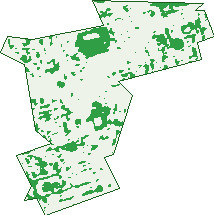
Green: 10 m cells where trees dominate, satellite 2021. Blue: water. The line is the suburb boundary.
| Canopy share, 1 m canopy height map, 2020 | 14.9% |
|---|---|
| Land with trees, 10 m satellite map, 2021 | 14.3% |
Demographics
Unemployment 4.1% · Labour-force participation 74.7%
Population by age in Newtown
| 0-4 | 515 |
|---|---|
| 5-14 | 896 |
| 15-19 | 462 |
| 20-24 | 1,457 |
| 25-34 | 4,238 |
| 35-44 | 2,517 |
| 45-54 | 1,987 |
| 55-64 | 1,422 |
| 65-74 | 799 |
| 75-84 | 296 |
| 85+ | 102 |
Dwelling types in Newtown
| House | 330 |
|---|---|
| Townhouse | 3,399 |
| Apartment | 2,598 |
| Other | 183 |
Households by weekly income in Newtown
| <$650 | 733 |
|---|---|
| $650-1,499 | 1,168 |
| $1,500-2,999 | 1,855 |
| $3,000+ | 2,441 |
Top ancestries in Newtown
| English | 5,132 |
|---|---|
| Australian | 3,963 |
| Irish | 2,423 |
| Other | 2,388 |
| Scottish | 1,672 |
| Chinese | 893 |
Housing tenure in Newtown
| Owned | 1,128 |
|---|---|
| Mortgage | 1,532 |
| Rented | 3,762 |
| Other | 69 |
Cars per household in Newtown
| 0 | 2,036 |
|---|---|
| 1 | 3,288 |
| 2 | 927 |
| 3 | 157 |
| 4+ | 53 |
Commute to work in Newtown
| Car | 1,417 |
|---|---|
| Train | 385 |
| Bus | 140 |
| Tram/ferry | 0 |
| Walked | 700 |
| Bicycle | 167 |
| Home | 5,237 |
Top countries of birth in Newtown
| England | 831 |
|---|---|
| New Zealand | 392 |
| China | 225 |
| United States | 206 |
| Ireland | 146 |
| Thailand | 146 |
Languages used at home in Newtown
| Mandarin | 263 |
|---|---|
| Spanish | 213 |
| Greek | 196 |
| Cantonese | 158 |
| Thai | 149 |
| French | 146 |
Birds & Wildlife Nearby
219,628 bird observations recorded near Newtown — most often seen:
- Rainbow Lorikeet (19,683)
- Australian White Ibis (18,571)
- Noisy Miner (17,104)
- Rock Dove (12,914)
- Australian Magpie (11,042)
- Common Myna (10,272)
- Welcome Swallow (9,474)
- Pied Currawong (9,281)
- Silver Gull (8,405)
- Australian Raven (8,298)
- Magpie-lark (6,797)
- Pacific Black Duck (6,797)
- Dusky Moorhen (6,791)
Show all 30 birds recorded near Newtown
- Crested Pigeon (5,972)
- Willie Wagtail (5,222)
- Spotted Turtle-dove (5,169)
- Little Black Cormorant (5,136)
- Eurasian Coot (4,786)
- Grey Butcherbird (4,742)
- Australasian Purple Swamphen (4,496)
- Australasian Figbird (4,484)
- Sulphur-crested Cockatoo (4,121)
- Laughing Kookaburra (4,109)
- Common Starling (4,062)
- Masked Lapwing (3,979)
- Little Pied Cormorant (3,898)
- Superb Fairy-wren (3,770)
- Red Wattlebird (3,464)
- Little Corella (3,401)
- White-faced Heron (3,388)
Sightings reported by observers, not a survey, so the counts show what people record rather than what lives here. Source: Atlas of Living Australia.
Nearby Suburbs
The closest suburbs to Newtown:
- Erskineville (0.8 km)
- Enmore (0.9 km)
- Eveleigh (1.1 km)
- Camperdown (1.2 km)
- Stanmore (1.4 km)
- Darlington (1.5 km)
- St Peters (1.6 km)
- Alexandria (1.7 km)
Embed this suburb
Add this free Newtown stat card to your own site — just copy the code:
Preview:
Cite this page
Quoting these figures? Copy the credit line:
Keep an eye on Newtown
One email when this data meaningfully changes — new census figures, prices, rankings. No spam, unsubscribe anytime.
Streets
- Albermarle Street (78)
- Albert Street (45)
- Alice Avenue (11)
- Alice Lane (10)
- Alice Street (658)
- Angel Street (85)
- Australia Street (127)
- Bailey Street (17)
- Baltic Street (44)
- Bedford Street (81)
- Bennett Street (39)
- Bishopgate Street (9)
- Brocks Lane (86)
- Brown Lane (7)
- Brown Street (176)
- Buckland Lane (2)
- Bucknell Lane (2)
- Bucknell Street (79)
- Burren Street (44)
- Camden Street (140)
- Campbell Street (65)
- Carillon Avenue (791)
- Chalder Street (12)
- Chelmsford Street (122)
- Church Street (105)
- Clara Street (14)
- College Street (36)
- Commodore Street (63)
- Copeland Avenue (7)
- Crescent Lane (1)
- Darley Street (244)
- Darlington Road (11)
- Denison Street (107)
- Dickson Street (77)
- Don Street (24)
- Edgeware Road (156)
- Egan Street (81)
- Eliza Street (11)
- Enmore Road (378)
- Erskineville Road (180)
- Federation Road (10)
- Ferndale Street (49)
- Fitzgerald Street (94)
- Fitzroy Street (45)
- Forbes Street (120)
- Fulham Street (45)
- Georgina Street (169)
- Gibbes Street (40)
- Gladstone Street (200)
- Goddard Street (6)
- Golden Grove Street (46)
- Gowrie Street (176)
- Harold Street (26)
- Hawken Street (37)
- Hennings Lane (1)
- Herbert Street (10)
- Holdsworth Street (34)
- Holmwood Street (73)
- Holt Street (8)
- Hordern Street (111)
- Iredale Street (103)
- John Street (25)
- Kent Street (81)
- King Street (1,587)
- Kingston Road (8)
- Laura Street (68)
- Leamington Avenue (32)
- Lennox Street (103)
- Linthorpe Lane (1)
- Linthorpe Street (80)
- Little Commodore Street (10)
- Little Queen Street (21)
- Longdown Street (18)
- Lord Street (204)
- Margaret Street (63)
- Mary Street (13)
- Missenden Road (174)
- Munni Street (58)
- Newman Lane (2)
- Newman Street (109)
- Norfolk Street (1)
- O'connell Street (97)
- Oxford Street (53)
- Park Lane (1)
- Pearl Street (64)
- Pemell Lane (24)
- Pemell Street (41)
- Phillip Street (72)
- Pine Street (32)
- Probert Street (155)
- Prospect Street (8)
- Queen Street (258)
- Railway Avenue (7)
- Railway Lane (1)
- Randle Street (21)
- Raper Street (45)
- Rawson Street (45)
- Reiby Lane (6)
- Reiby Street (65)
- Rochester Street (2)
- Samuel Kent Lane (1)
- Simmons Street (50)
- Sloane Street (29)
- St John Street (7)
- St Marys Street (31)
- Station Street (307)
- Susan Street (48)
- Trade Lane (1)
- Trade Street (50)
- Union Street (118)
- Victoria Street (4)
- Walenore Avenue (6)
- Warren Ball Avenue (25)
- Watkin Street (90)
- Wells Street (173)
- Whateley Lane (5)
- Whateley Street (13)
- Whitehorse Street (12)
- Wilford Lane (2)
- Wilford Street (36)
- Wilson Street (411)
- Yaralla Street (30)