Narooma NSW 2546
2,905 addresses · 102 streets
Eden-Monaro Electorate › Eurobodalla LGA › Narooma · 280 km from Sydney
📦 Thinking of moving here? Read the Narooma moving guide

Living Here
Narooma is a suburb of New South Wales, home to about 2,731 people, with a median age of 58. The typical household earns around $926 a week, with median rent near $260 a week. Most homes are houses. About 74% of households own their home and 25% rent. Most workers drive to work. Common community backgrounds include English, Australian, Irish. On the ABS socio-economic scale it sits in decile 2 of 10 nationally — a more disadvantaged area.
Over time — Census 2001 → 2021
Dashed line: district figures for the Narooma - Bermagui statistical area (SA2), the smallest area the ABS published before 2011. Solid line: Narooma itself.
Getting Around & Local Services
2 schools
3 supermarkets
1 medical clinic
1 dentist
1 optometrist
1 vet
1 childcare centre
1 library
1 post office
3 service stations
3 gyms & sports centres
1 golf club
2 bakeries
1 butcher
2 hardware stores
1 hairdresser
1 beauty salon
1 mechanic
Getting around. Airport: Moruya Airport, 36.1 km north.
Socio-economic Standing
Deciles from 1 (lowest) to 10 (highest), against all Australian suburbs. The overall figure weighs advantage and disadvantage together; economic resources counts income and housing, and education & jobs counts qualifications and occupation. They often differ. Source: ABS SEIFA 2021.
Tree cover
🌳 Tree canopy: 82.7% share of land under canopy · satellite map, 2020
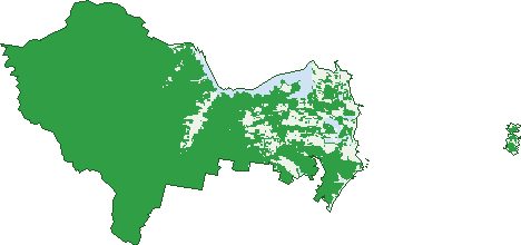
Green: 10 m cells where trees dominate, satellite 2021. Blue: water. The line is the suburb boundary.
| Canopy share, 1 m canopy height map, 2020 | 82.7% |
|---|---|
| Land with trees, 10 m satellite map, 2021 | 89.2% |
Demographics
Unemployment 3.9% · Labour-force participation 40.8%
Population by age in Narooma
| 0-4 | 93 |
|---|---|
| 5-14 | 233 |
| 15-19 | 118 |
| 20-24 | 73 |
| 25-34 | 192 |
| 35-44 | 201 |
| 45-54 | 312 |
| 55-64 | 466 |
| 65-74 | 677 |
| 75-84 | 271 |
| 85+ | 99 |
Dwelling types in Narooma
| House | 850 |
|---|---|
| Townhouse | 200 |
| Apartment | 107 |
| Other | 85 |
Households by weekly income in Narooma
| <$650 | 382 |
|---|---|
| $650-1,499 | 447 |
| $1,500-2,999 | 245 |
| $3,000+ | 78 |
Top ancestries in Narooma
| English | 1,169 |
|---|---|
| Australian | 1,008 |
| Irish | 358 |
| Scottish | 324 |
| Ancestry NS | 168 |
| Aboriginal | 150 |
Housing tenure in Narooma
| Owned | 663 |
|---|---|
| Mortgage | 233 |
| Rented | 307 |
| Other | 16 |
Cars per household in Narooma
| 0 | 96 |
|---|---|
| 1 | 565 |
| 2 | 390 |
| 3 | 110 |
| 4+ | 59 |
Commute to work in Narooma
| Car | 617 |
|---|---|
| Train | 0 |
| Bus | 4 |
| Tram/ferry | 0 |
| Walked | 55 |
| Bicycle | 3 |
| Home | 107 |
Top countries of birth in Narooma
| England | 147 |
|---|---|
| New Zealand | 35 |
| Germany | 23 |
| India | 17 |
| United States | 16 |
| Scotland | 14 |
Languages used at home in Narooma
| German | 12 |
|---|---|
| Nepali | 7 |
| Punjabi | 7 |
| Vietnamese | 7 |
| Cantonese | 6 |
| Italian | 6 |
Birds & Wildlife Nearby
25,397 bird observations recorded near Narooma — most often seen:
- Little Penguin (3,016)
- Silver Gull (1,665)
- Masked Lapwing (1,136)
- Australian Pied Oystercatcher (1,122)
- Australian Pelican (1,104)
- Little Pied Cormorant (1,037)
- Crested Tern (1,028)
- White-faced Heron (1,012)
- Welcome Swallow (948)
- Rainbow Lorikeet (946)
- Great Cormorant (922)
- Australian Magpie (895)
- Black Swan (819)
Show all 30 birds recorded near Narooma
- Superb Fairy-wren (750)
- Red Wattlebird (743)
- Bell Miner (681)
- Bar-tailed Godwit (673)
- White-bellied Sea-eagle (672)
- Australian Raven (659)
- Little Black Cormorant (599)
- Little Wattlebird (585)
- New Holland Honeyeater (566)
- Rock Dove (541)
- Lewin's Honeyeater (497)
- Little Egret (493)
- Pied Currawong (484)
- Laughing Kookaburra (465)
- Pied Cormorant (450)
- Brown Thornbill (447)
- Eastern Yellow Robin (442)
Sightings reported by observers, not a survey, so the counts show what people record rather than what lives here. Source: Atlas of Living Australia.
Nearby Suburbs
The closest suburbs to Narooma:
- North Narooma (2.4 km)
- Kianga (3.3 km)
- Dalmeny (6.5 km)
- Corunna (6.7 km)
- Mystery Bay (8.6 km)
- Central Tilba (9.3 km)
- Tilba Tilba (13.5 km)
- Potato Point (14.6 km)
Embed this suburb
Add this free Narooma stat card to your own site — just copy the code:
Preview:
Cite this page
Quoting these figures? Copy the credit line:
Keep an eye on Narooma
One email when this data meaningfully changes — new census figures, prices, rankings. No spam, unsubscribe anytime.
Streets
- Albert Park Lane (7)
- Angle Place (13)
- Angle Street (11)
- Ballingalla Street (47)
- Bapaume Road (1)
- Bar Rock Road (1)
- Barker Parade (30)
- Bay Lane (5)
- Bay Street (48)
- Bettini Lane (2)
- Bluewater Drive (15)
- Bold Hill Road (2)
- Bowen Street (4)
- Brice Street (8)
- Bridge Court (2)
- Burbidge Lane (4)
- Burrawang Street (24)
- Campbell Street (75)
- Canty Street (26)
- Cemetery Road (1)
- Chisholm Place (16)
- Clarke Street (31)
- Cobra Road (1)
- Cole Crescent (20)
- Collins Crescent (32)
- Corunna Road (18)
- Corunna Street (3)
- Costin Street (34)
- Cove Lane (3)
- Curt Lane (9)
- Davison Street (26)
- Dorothy Drive (37)
- Dromedary Terrace (7)
- Dudleys Lane (3)
- Farncomb Avenue (4)
- Field Street (7)
- Flying Fox Road (14)
- Forsters Bay Road (90)
- Fuller Lane (5)
- Gareth Avenue (13)
- Garvan Lane (3)
- Garvan Street (12)
- Gem Crescent (27)
- Gina Court (4)
- Glasshouse Rocks Road (25)
- Golf Lane (2)
- Graham Street (23)
- Greenvale Drive (1)
- Harper Crescent (17)
- Harrington Road (21)
- Hobbs Point Road (5)
- Hopkins Place (20)
- Hyland Avenue (20)
- Isabel Street (38)
- Lake View Drive (24)
- Lilyvale Place (27)
- Loader Parade (34)
- Lynch Street (14)
- Marine Drive (50)
- Mcmillan Road (102)
- Mitchell Place (11)
- Montague Street (44)
- Murphy Place (13)
- Nichelsen Street (9)
- Noorooma Crescent (32)
- Noorooma Lane (4)
- Old Highway (95)
- Old South Coast Road (23)
- Oyster Lane (2)
- Payne Street (145)
- Pilot Street (6)
- Princes Highway (779)
- Punkalla Tilba Road (3)
- Rainforest Parkway (27)
- Riley Street (21)
- Ringlands Road (5)
- Riverside Drive (45)
- Ron Gross Lane (2)
- Ross Street (14)
- Scenic Drive (2)
- Seaeagle Close (5)
- Sheaffe Street (7)
- Shingle Hut Road (5)
- Taylor Street (20)
- Tebbs Road (10)
- The Loop (22)
- The Slipway (6)
- Thompsons Lane (4)
- Tilba Road S (11)
- Tilba Street (82)
- Treetops Street (4)
- Vuko Place (3)
- Wagonga Scenic Drive (65)
- Wagonga Street (87)
- Waterview Drive (3)
- Wharf Street (11)
- Wild Duck Lane (4)
- Willcocks Avenue (47)
- Willis Boulevard (5)
- Wonga Road (24)
- Woodlands Drive (18)
- Yellowfin Close (12)