Murwillumbah NSW 2484
4,732 addresses · 142 streets
Richmond Electorate › Tweed LGA › Murwillumbah · 649 km from Sydney
📦 Thinking of moving here? Read the Murwillumbah moving guide

Living Here
Murwillumbah is a suburb of New South Wales, home to about 7,616 people, with a median age of 46. The typical household earns around $1,147 a week, with median rent near $346 a week. Most homes are houses. About 67% of households own their home and 30% rent. Most workers drive to work. Common community backgrounds include English, Australian, Irish. On the ABS socio-economic scale it sits in decile 2 of 10 nationally — a more disadvantaged area.
Over time — Census 2001 → 2021
Dashed line: district figures for the Murwillumbah statistical area (SA2), the smallest area the ABS published before 2011. Solid line: Murwillumbah itself.
Getting Around & Local Services
3 supermarkets
2 Catholic churches
2 doctors & medical clinics
1 optometrist
1 hospital
1 library
1 post office
7 service stations
3 gyms & sports centres
1 golf club
2 bakeries
1 hardware store
2 beauty salons
Getting around. Airport: Gold Coast Airport, 21.9 km north-east.
Socio-economic Standing
Deciles from 1 (lowest) to 10 (highest), against all Australian suburbs. The overall figure weighs advantage and disadvantage together; economic resources counts income and housing, and education & jobs counts qualifications and occupation. They often differ. Source: ABS SEIFA 2021.
Tree cover
🌳 Tree canopy: 9.8% share of land under canopy · satellite map, 2020
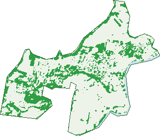
Green: 10 m cells where trees dominate, satellite 2021. Blue: water. The line is the suburb boundary.
| Canopy share, 1 m canopy height map, 2020 | 9.8% |
|---|---|
| Land with trees, 10 m satellite map, 2021 | 26.7% |
Demographics
Unemployment 5.6% · Labour-force participation 51.2%
Population by age in Murwillumbah
| 0-4 | 362 |
|---|---|
| 5-14 | 1,025 |
| 15-19 | 438 |
| 20-24 | 292 |
| 25-34 | 669 |
| 35-44 | 894 |
| 45-54 | 940 |
| 55-64 | 1,058 |
| 65-74 | 940 |
| 75-84 | 620 |
| 85+ | 380 |
Dwelling types in Murwillumbah
| House | 2,254 |
|---|---|
| Townhouse | 215 |
| Apartment | 481 |
| Other | 14 |
Households by weekly income in Murwillumbah
| <$650 | 740 |
|---|---|
| $650-1,499 | 1,004 |
| $1,500-2,999 | 765 |
| $3,000+ | 249 |
Top ancestries in Murwillumbah
| English | 3,276 |
|---|---|
| Australian | 2,884 |
| Irish | 1,125 |
| Scottish | 919 |
| Ancestry NS | 642 |
| Other | 495 |
Housing tenure in Murwillumbah
| Owned | 1,023 |
|---|---|
| Mortgage | 929 |
| Rented | 894 |
| Other | 88 |
Cars per household in Murwillumbah
| 0 | 234 |
|---|---|
| 1 | 1,219 |
| 2 | 1,043 |
| 3 | 289 |
| 4+ | 141 |
Commute to work in Murwillumbah
| Car | 2,127 |
|---|---|
| Train | 0 |
| Bus | 15 |
| Tram/ferry | 0 |
| Walked | 105 |
| Bicycle | 13 |
| Home | 302 |
Top countries of birth in Murwillumbah
| England | 267 |
|---|---|
| New Zealand | 147 |
| India | 98 |
| Germany | 38 |
| Philippines | 37 |
| South Africa | 30 |
Languages used at home in Murwillumbah
| Punjabi | 75 |
|---|---|
| Spanish | 44 |
| French | 32 |
| German | 29 |
| Hindi | 21 |
| Thai | 14 |
Birds & Wildlife Nearby
15,950 bird observations recorded near Murwillumbah — most often seen:
- Cattle Egret (4,566)
- Rainbow Lorikeet (932)
- Australian White Ibis (812)
- Noisy Miner (619)
- Australian Magpie (613)
- Magpie-lark (572)
- Pied Currawong (504)
- Australian Wood Duck (476)
- Australasian Figbird (449)
- Welcome Swallow (440)
- Pacific Black Duck (431)
- Little Corella (405)
- Willie Wagtail (398)
Show all 30 birds recorded near Murwillumbah
- Crested Pigeon (377)
- Torresian Crow (369)
- Masked Lapwing (358)
- Laughing Kookaburra (348)
- Noisy Friarbird (311)
- Lewin's Honeyeater (294)
- Australasian Purple Swamphen (289)
- Australian Brush-turkey (286)
- Pied Butcherbird (252)
- Common Myna (245)
- Black-faced Cuckoo-shrike (234)
- Spotted Turtle-dove (233)
- Dusky Moorhen (232)
- Bar-shouldered Dove (230)
- Eastern Rosella (227)
- White-headed Pigeon (225)
- Brown Honeyeater (223)
Sightings reported by observers, not a survey, so the counts show what people record rather than what lives here. Source: Atlas of Living Australia.
Nearby Suburbs
The closest suburbs to Murwillumbah:
- Bray Park (1.2 km)
- Kynnumboon (2.7 km)
- South Murwillumbah (2.9 km)
- Byangum (3.6 km)
- North Arm (3.8 km)
- Dunbible (4.4 km)
- Tygalgah (4.7 km)
- Nobbys Creek (5.5 km)
Embed this suburb
Add this free Murwillumbah stat card to your own site — just copy the code:
Preview:
Cite this page
Quoting these figures? Copy the credit line:
Keep an eye on Murwillumbah
One email when this data meaningfully changes — new census figures, prices, rankings. No spam, unsubscribe anytime.
Streets
- Almac Avenue (8)
- Amethyst Place (7)
- Amwil Avenue (9)
- Auro Court (27)
- Bagoo Avenue (11)
- Baker Street (43)
- Banner Lane (10)
- Banner Street (4)
- Barnby Street (52)
- Bent Street (26)
- Boscabel Avenue (40)
- Brisbane Street (47)
- Bruce Lane (2)
- Byangum Road (282)
- Candleberry Street (7)
- Cane Road (3)
- Castle Field Drive (99)
- Central Parade (33)
- Charles Lane (6)
- Charles Street (62)
- Church Lane (47)
- Church Street (17)
- Coachwood Court (4)
- Commercial Road (136)
- Condong Street (46)
- Coral Fern Circuit (77)
- Countryside Drive (58)
- Creek Street (13)
- Dorothy Street (51)
- Dorset Street (44)
- Elizabeth Street (11)
- Elouera Terrace (1)
- Emerald Place (6)
- Eveleigh Street (17)
- Ewing Street (79)
- Eyles Avenue (62)
- Factory Lane (4)
- Fern Avenue (22)
- Ferryview Lane (1)
- Fig Court (18)
- Florin Lane (8)
- Foot Street (1)
- Frances Street (19)
- Frangela Drive (17)
- Freshfield Way (10)
- Fulford Lane (1)
- George Street (50)
- Gold Leaf Crescent (16)
- Golden Links Drive (45)
- Grevillia Parade (16)
- Hall Drive (82)
- Hartigan Street (31)
- Harwood Street (43)
- Hemlock Street (12)
- Hideaway Lane (2)
- Ingram Place (261)
- Jacaranda Avenue (24)
- James Street (43)
- Joshua Street (36)
- Kendon Avenue (13)
- King Street (36)
- Kirby Street (2)
- Kyogle Road (10)
- Lakeside Drive (63)
- Lamington Way (20)
- Linden Court (6)
- Martin Street (11)
- Matheson Way (10)
- Mayal Lane (1)
- Mayal Street (19)
- Mcpherson Court (53)
- Mooball Street (42)
- Mount Ballow Avenue (13)
- Mount Barney Court (6)
- Mount Ernest Crescent (55)
- Mount Lindesay Avenue (10)
- Murwillumbah Street (255)
- Myrtle Lane (1)
- Myrtle Street (73)
- Neville Close (4)
- North Arm Road (17)
- Nullum Lane (12)
- Nullum Street (45)
- Oakbank Terrace (50)
- Oasis Walk (10)
- Old Ferry Road (13)
- Old Lismore Road (35)
- Opal Place (14)
- Palm Walk (4)
- Peri Street (8)
- Peter Street (17)
- Platinum Place (11)
- Point Lookout Chase (17)
- Prince Street (60)
- Proudfoots Lane (2)
- Queen Street (66)
- Queensland Road (14)
- Reynolds Street (21)
- River Gum Court (9)
- Riverbend Way (47)
- Riveroak Drive (111)
- Riverview Street (123)
- Rous River Way (47)
- Rous Street (16)
- Saddle Way (10)
- Samuel Court (11)
- Sapphire Street (5)
- Short Street (6)
- Silkpod Avenue (27)
- Somerville Circuit (27)
- Sorrel Court (20)
- Sovereign Way (15)
- Spring Lane (15)
- Spring Street (14)
- Sunnyside Lane (14)
- Sylvan Street (2)
- Talganda Terrace (51)
- Tamarisk Avenue (23)
- The Plateau (23)
- Thompson Street (28)
- Tombonda Road (56)
- Topaz Place (5)
- Tree Street (9)
- Tree Tops Boulevard (86)
- Tulipwood Court (38)
- Tumbulgum Road (101)
- Turquoise Place (9)
- Tweed Street (24)
- Tyalgum Road (14)
- Uki Street (2)
- View Parade (8)
- Wade Street (23)
- Wagawn Drive (15)
- Waterloo Street (9)
- Wentworth Street (13)
- West End Street (35)
- Wharf Street (58)
- William Street (75)
- Wilson Lane (2)
- Wollumbin Street (142)
- Woodgee Street (16)
- York Street (20)