Mudgee NSW 2850
7,698 addresses · 219 streets
Calare Electorate › Mid-Western Regional LGA › Mudgee · 207 km from Sydney
📦 Thinking of moving here? Read the Mudgee moving guide

Living Here
Mudgee is a suburb of New South Wales, home to about 11,457 people, with a median age of 36. The typical household earns around $1,678 a week, with median rent near $360 a week. Most homes are houses. About 63% of households own their home and 36% rent. Most workers drive to work. Common community backgrounds include Australian, English, Irish. On the ABS socio-economic scale it sits in decile 3 of 10 nationally — a more disadvantaged area.
Over time — Census 2001 → 2021
Dashed line: district figures for the Mudgee statistical area (SA2), the smallest area the ABS published before 2011. Solid line: Mudgee itself.
Getting Around & Local Services
3 supermarkets
1 Catholic church
1 medical clinic
1 physiotherapist
1 optometrist
1 hospital
4 childcare & kindergartens
1 library
1 post office
6 service stations
5 gyms & sports centres
1 golf club
3 butchers
3 hardware stores
2 hairdressers
1 beauty salon
1 mechanic
1 plumber
Getting around. Airport: Mudgee Airport, 5 km north-east.
Socio-economic Standing
Deciles from 1 (lowest) to 10 (highest), against all Australian suburbs. The overall figure weighs advantage and disadvantage together; economic resources counts income and housing, and education & jobs counts qualifications and occupation. They often differ. Source: ABS SEIFA 2021.
Tree cover
🌳 Tree canopy: 45.7% share of land under canopy · satellite map, 2020
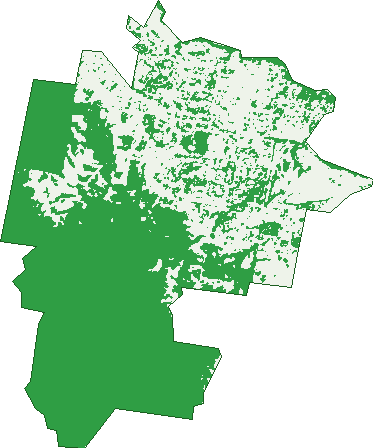
Green: 10 m cells where trees dominate, satellite 2021. Blue: water. The line is the suburb boundary.
| Canopy share, 1 m canopy height map, 2020 | 45.7% |
|---|---|
| Land with trees, 10 m satellite map, 2021 | 60.8% |
Demographics
Unemployment 3.6% · Labour-force participation 62%
Population by age in Mudgee
| 0-4 | 832 |
|---|---|
| 5-14 | 1,585 |
| 15-19 | 634 |
| 20-24 | 613 |
| 25-34 | 1,688 |
| 35-44 | 1,423 |
| 45-54 | 1,306 |
| 55-64 | 1,245 |
| 65-74 | 1,038 |
| 75-84 | 761 |
| 85+ | 331 |
Dwelling types in Mudgee
| House | 3,686 |
|---|---|
| Townhouse | 546 |
| Apartment | 49 |
| Other | 73 |
Households by weekly income in Mudgee
| <$650 | 740 |
|---|---|
| $650-1,499 | 1,104 |
| $1,500-2,999 | 1,348 |
| $3,000+ | 847 |
Top ancestries in Mudgee
| Australian | 5,013 |
|---|---|
| English | 4,985 |
| Irish | 1,449 |
| Scottish | 1,082 |
| Aboriginal | 819 |
| Ancestry NS | 719 |
Housing tenure in Mudgee
| Owned | 1,308 |
|---|---|
| Mortgage | 1,381 |
| Rented | 1,543 |
| Other | 29 |
Cars per household in Mudgee
| 0 | 271 |
|---|---|
| 1 | 1,494 |
| 2 | 1,668 |
| 3 | 552 |
| 4+ | 272 |
Commute to work in Mudgee
| Car | 3,962 |
|---|---|
| Train | 0 |
| Bus | 13 |
| Tram/ferry | 0 |
| Walked | 231 |
| Bicycle | 20 |
| Home | 322 |
Top countries of birth in Mudgee
| England | 242 |
|---|---|
| New Zealand | 105 |
| Philippines | 62 |
| India | 49 |
| Nepal | 47 |
| South Africa | 34 |
Languages used at home in Mudgee
| Nepali | 50 |
|---|---|
| Punjabi | 46 |
| Tagalog | 37 |
| Spanish | 29 |
| Mandarin | 24 |
| Bengali | 21 |
Birds & Wildlife Nearby
28,926 bird observations recorded near Mudgee — most often seen:
- Superb Fairy-wren (1,420)
- Willie Wagtail (1,388)
- Magpie-lark (1,385)
- Australian Magpie (1,356)
- Galah (1,326)
- White-plumed Honeyeater (1,275)
- Pacific Black Duck (1,192)
- Dusky Moorhen (1,189)
- Red-rumped Parrot (1,153)
- Welcome Swallow (1,017)
- Red Wattlebird (993)
- Pied Currawong (983)
- Common Starling (980)
Show all 30 birds recorded near Mudgee
- Eastern Rosella (925)
- Red-browed Finch (867)
- Eurasian Coot (862)
- Grey Shrike-thrush (861)
- Laughing Kookaburra (860)
- Grey Teal (847)
- Crested Pigeon (832)
- Australian Raven (793)
- Sulphur-crested Cockatoo (788)
- Australian Wood Duck (780)
- Peaceful Dove (774)
- Australasian Purple Swamphen (727)
- Black-faced Cuckoo-shrike (714)
- Australasian Grebe (704)
- Noisy Friarbird (674)
- Rainbow Lorikeet (674)
- Australian Reed Warbler (587)
Sightings reported by observers, not a survey, so the counts show what people record rather than what lives here. Source: Atlas of Living Australia.
Nearby Suburbs
The closest suburbs to Mudgee:
- Putta Bucca (2.9 km)
- Bombira (3.4 km)
- Milroy (3.8 km)
- Caerleon (4.1 km)
- Spring Flat (4.8 km)
- Burrundulla (5 km)
- Buckaroo (6.8 km)
- Mount Frome (7 km)
Embed this suburb
Add this free Mudgee stat card to your own site — just copy the code:
Preview:
Cite this page
Quoting these figures? Copy the credit line:
Keep an eye on Mudgee
One email when this data meaningfully changes — new census figures, prices, rankings. No spam, unsubscribe anytime.
Streets
- Abernethy Close (26)
- Acacia Grove (14)
- Adams Street (54)
- Albens Lane (13)
- Alexander Dawson Court (19)
- Atkinson Street (19)
- Augusta Crescent (8)
- Avisford Court (13)
- Banjo Paterson Avenue (88)
- Barigan Street (32)
- Barlow Court (8)
- Barrington Court (6)
- Baskerville Drive (29)
- Bateman Avenue (38)
- Bawden Road (26)
- Bell Street (18)
- Bellevue Road (115)
- Belmore Street (18)
- Birch Grove (21)
- Black Springs Road (3)
- Blackman Crescent (15)
- Bligh Close (6)
- Boundary Street (2)
- Braeburn Place (3)
- Brian Heber Grove (23)
- Broadhead Road (26)
- Bruce Road (43)
- Bryant Lane (2)
- Burgundy Road (19)
- Burrundulla Avenue (55)
- Burrundulla Road (13)
- Byron Place (19)
- Caerleon Court (6)
- Cameron Street (17)
- Carolina Crescent (28)
- Cassilis Road (1)
- Cassin Lane (13)
- Castlereagh Highway (5)
- Catleen Crescent (11)
- Cedar Avenue (26)
- Chappell Close (18)
- Charles Lester Place (22)
- Church Street (372)
- Clare Court (14)
- Clarendon Place (5)
- Clarke Street (1)
- Clifton Avenue (12)
- Cohen Street (23)
- Common Road (14)
- Constantia Road (24)
- Cook Place (11)
- Costigan Court (13)
- Court Street (96)
- Cox Street (134)
- Craigmoor Road (1)
- Croake Way (9)
- Darren Drive (14)
- Denison Street (263)
- Denton Close (10)
- Depot Road (44)
- Dewhurst Drive (66)
- Dickson Court (21)
- Doug Gudgeon Drive (22)
- Douro Street (95)
- Dunnachie Street (31)
- Dunphy Crescent (35)
- Durack Court (11)
- Eleanor Dark Court (13)
- Engineers Road (1)
- Fairy Dale Lane (1)
- Fairydale Lane (29)
- Farthing Lane (12)
- Faucett Drive (26)
- Fifth Street (4)
- First Street (19)
- Fleetwood Avenue (9)
- Flinders Avenue (16)
- Flirtation Avenue (20)
- Florence Close (24)
- Fourth Street (6)
- Gawthorne Place (24)
- George Street (126)
- Gilham Lane (3)
- Gladstone Street (270)
- Glenayr Close (7)
- Glenmore Street (20)
- Goodlet Lane (21)
- Grant Bruce Court (9)
- Grant Street (17)
- Grathlyn Court (8)
- Gundys Lane (10)
- Hardwick Avenue (28)
- Hardy Crescent (38)
- Hargraves Road (2)
- Havilah Terrace (21)
- Headley Place (11)
- Hennessy Place (18)
- Henry Bayly Drive (74)
- Hermitage Close (10)
- Honey Lane (10)
- Horatio Lane (3)
- Horatio Street (172)
- Hughson Avenue (31)
- Imber Court (6)
- Industrial Avenue (67)
- Inglis Street (121)
- Inverness Avenue (41)
- John Aarts Court (14)
- Julia Court (21)
- Kauri Lane (2)
- Kellett Drive (48)
- Kilkenny Avenue (21)
- King Street (11)
- Kurtz Court (4)
- Lahy Court (29)
- Lang Street (21)
- Lawson Street (162)
- Lewis Street (193)
- Lions Drive (134)
- Lisbon Road (21)
- Lochiel Lane (5)
- Lockwood Street (18)
- Lovejoy Street (26)
- Lowana Close (26)
- Loy Avenue (18)
- Lynwood Avenue (12)
- Lyons Lane (6)
- Macquarie Drive (67)
- Madeira Road (96)
- Maher Place (18)
- Market Street (348)
- Marshfield Lane (15)
- Marskell Circuit (36)
- Mason Grove (4)
- Mcewan Street (2)
- Mcewen Street (2)
- Mcfarlane Street (6)
- Mcgregor Place (25)
- Mealey Street (29)
- Meares Street (32)
- Melton Road (65)
- Menah Avenue (20)
- Menchin Street (16)
- Meroo Crescent (4)
- Michelle Court (8)
- Miller Crescent (14)
- Mortimer Street (375)
- Mount Misery Road (4)
- Mountain View Road (29)
- Mulgoa Way (103)
- Mulholland Court (11)
- Nashs Flat Place (29)
- Nicholson Street (54)
- Nolan Lane (2)
- Norman Road (43)
- Oakfield Close (7)
- Old Reservoir Road (4)
- Oporto Road (115)
- Orth Court (1)
- Palermo Road (13)
- Palmer Avenue (11)
- Park Avenue (8)
- Park Street (14)
- Paterson Street (14)
- Perry Street (111)
- Phillip Close (12)
- Pirie Close (8)
- Putta Bucca Road (8)
- Quinn Place (1)
- Ray Gooley Drive (22)
- Rayner Street (19)
- Redbank Road (43)
- Rheinberger Avenue (24)
- Richards Street (23)
- Rifle Range Road (28)
- River Lane (2)
- Robert Jones Street (26)
- Robertson Road (15)
- Robertson Street (108)
- Roth Court (25)
- Rowe Street (8)
- Saleyards Lane (69)
- Sawpit Road (6)
- Sawyers Place (8)
- Scenic Close (13)
- Second Street (15)
- Short Street (92)
- Sixth Street (4)
- Smith Street (8)
- Spring Road (58)
- Stan Boal Court (11)
- Stirling Court (10)
- Sutherland Grove (10)
- Swords Court (14)
- Sydney Road (188)
- Tebbutt Court (14)
- Tennant Close (22)
- Third Street (24)
- Thomas Clark Place (28)
- Thomas Clarke Place (27)
- Tiendebah Road (3)
- Trefusis Avenue (20)
- Vera Court (37)
- View Street (12)
- Wanda Crescent (6)
- Wandoona Court (14)
- Waterworks Road (46)
- Wells Court (7)
- Wentworth Avenue (27)
- White Circle (116)
- Wilbertree Road (1)
- Wilkins Crescent (12)
- Willem Place (8)
- Wilton Grove (7)
- Winbourne Street (77)
- Winter Street (70)
- Woodside Close (31)
- Xavier Court (23)
- Yamble Close (11)