Mittagong NSW 2575
4,293 addresses · 127 streets
Whitlam Electorate › Wingecarribee LGA › Mittagong · 96 km from Sydney
📦 Thinking of moving here? Read the Mittagong moving guide

Living Here
Mittagong is a suburb of New South Wales, home to about 6,090 people, with a median age of 49. The typical household earns around $1,425 a week, with median rent near $400 a week. Most homes are houses. About 69% of households own their home and 28% rent. Most workers drive to work. Common community backgrounds include English, Australian, Irish. On the ABS socio-economic scale it sits in decile 7 of 10 nationally — a mid-range area.
Over time — Census 2001 → 2021
Dashed line: district figures for the Mittagong statistical area (SA2), the smallest area the ABS published before 2011. Solid line: Mittagong itself.
Getting Around & Local Services
2 supermarkets
1 Catholic church
1 pharmacy
2 doctors & medical clinics
2 dentists
2 physiotherapists
3 optometrists
2 libraries
2 post offices
7 service stations
2 bakeries
1 butcher
2 beauty salons
2 mechanics
Getting around. Train station: Mittagong, 100 m south-east · Airport: Shellharbour Airport, 33.6 km east.
Socio-economic Standing
Deciles from 1 (lowest) to 10 (highest), against all Australian suburbs. The overall figure weighs advantage and disadvantage together; economic resources counts income and housing, and education & jobs counts qualifications and occupation. They often differ. Source: ABS SEIFA 2021.
Tree cover
🌳 Tree canopy: 46.1% share of land under canopy · satellite map, 2020
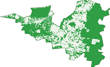
Green: 10 m cells where trees dominate, satellite 2021. Blue: water. The line is the suburb boundary.
| Canopy share, 1 m canopy height map, 2020 | 46.1% |
|---|---|
| Land with trees, 10 m satellite map, 2021 | 62.4% |
Demographics
Unemployment 3.7% · Labour-force participation 54.3%
Population by age in Mittagong
| 0-4 | 293 |
|---|---|
| 5-14 | 609 |
| 15-19 | 351 |
| 20-24 | 228 |
| 25-34 | 617 |
| 35-44 | 632 |
| 45-54 | 767 |
| 55-64 | 798 |
| 65-74 | 879 |
| 75-84 | 641 |
| 85+ | 279 |
Dwelling types in Mittagong
| House | 2,063 |
|---|---|
| Townhouse | 187 |
| Apartment | 176 |
| Other | 29 |
Households by weekly income in Mittagong
| <$650 | 497 |
|---|---|
| $650-1,499 | 723 |
| $1,500-2,999 | 631 |
| $3,000+ | 476 |
Top ancestries in Mittagong
| English | 2,670 |
|---|---|
| Australian | 2,095 |
| Irish | 924 |
| Scottish | 813 |
| Other | 607 |
| Ancestry NS | 307 |
Housing tenure in Mittagong
| Owned | 1,034 |
|---|---|
| Mortgage | 639 |
| Rented | 678 |
| Other | 83 |
Cars per household in Mittagong
| 0 | 137 |
|---|---|
| 1 | 1,027 |
| 2 | 840 |
| 3 | 278 |
| 4+ | 159 |
Commute to work in Mittagong
| Car | 1,572 |
|---|---|
| Train | 20 |
| Bus | 4 |
| Tram/ferry | 5 |
| Walked | 100 |
| Bicycle | 3 |
| Home | 645 |
Top countries of birth in Mittagong
| England | 330 |
|---|---|
| Nepal | 137 |
| India | 119 |
| New Zealand | 98 |
| Philippines | 53 |
| Scotland | 40 |
Languages used at home in Mittagong
| Nepali | 144 |
|---|---|
| Punjabi | 42 |
| Italian | 36 |
| Mandarin | 32 |
| Tagalog | 31 |
| French | 25 |
Birds & Wildlife Nearby
24,821 bird observations recorded near Mittagong — most often seen:
- Australian Wood Duck (1,576)
- South-eastern Crimson Rosella (1,374)
- Pacific Black Duck (1,272)
- Australian Magpie (1,262)
- Crimson Rosella (1,248)
- Sulphur-crested Cockatoo (1,162)
- Coastal New South Wales Australian Magpie (1,112)
- Pied Currawong (946)
- Southern Laughing Kookaburra (869)
- Laughing Kookaburra (860)
- Eurasian Coot (824)
- Little Raven (819)
- Eastern Sulphur-crested Cockatoo (813)
Show all 30 birds recorded near Mittagong
- Eastern Pied Currawong (810)
- Dusky Moorhen (763)
- Tasmanian Grey Fantail (684)
- Red Wattlebird (679)
- Noisy Miner (664)
- Magpie-lark (656)
- Southern Noisy Miner (651)
- Common Myna (638)
- Australian King-parrot (621)
- Southern Magpie-lark (612)
- Eastern Red Wattlebird (602)
- Northern Superb Fairy-wren (586)
- Little Corella (579)
- South-eastern Brown Thornbill (562)
- Brown Thornbill (545)
- Eastern Spinebill (529)
- Australian Raven (503)
Sightings reported by observers, not a survey, so the counts show what people record rather than what lives here. Source: Atlas of Living Australia.
Nearby Suburbs
The closest suburbs to Mittagong:
Embed this suburb
Add this free Mittagong stat card to your own site — just copy the code:
Preview:
Cite this page
Quoting these figures? Copy the credit line:
Keep an eye on Mittagong
One email when this data meaningfully changes — new census figures, prices, rankings. No spam, unsubscribe anytime.
Streets
- Acacia Street (7)
- Albert Lane (4)
- Albert Street (33)
- Albion Lane (1)
- Albion Street (4)
- Alexandra Place (10)
- Alfred Lane (2)
- Alfred Street (76)
- Alice Street (24)
- Anne Street (36)
- Apple Gate Close (18)
- Argyle Street (8)
- Arthur Street (36)
- Aylmerton Road (4)
- Barton Close (12)
- Beatrice Street (8)
- Belgrave Street (7)
- Belmore Street (22)
- Bessemer Street (44)
- Blomfield Crescent (13)
- Bong Bong Road (110)
- Bourne Close (18)
- Bowral Road (175)
- Bracken Street (9)
- Brewster Street (61)
- Buckmans Lane (6)
- Camellia Place (8)
- Cavendish Street (47)
- Chalker Crescent (25)
- Cherry Tree Place (14)
- Colo Street (102)
- Conifer Place (7)
- Cook Street (28)
- Dalton Street (39)
- Darch Place (13)
- Davy Street (41)
- Devon Street (9)
- Diamond Fields Road (19)
- Downes Place (4)
- Duke Street (28)
- Edward Lane (18)
- Edward Street (63)
- Elizabeth Street (9)
- Ernest Street (11)
- Etheridge Street (103)
- Evans Street (74)
- Faraday Street (33)
- Farnham Close (5)
- Ferguson Crescent (23)
- Fernbrook Crescent (13)
- Fitzroy Street (18)
- Frankland Street (27)
- Gibbergunya Lane (4)
- Government Road (3)
- Greyladyes Lane (1)
- Harnett Lane (12)
- Hawkins Drive (1)
- Helena Street (18)
- Henderson Avenue (40)
- Hillside Close (20)
- Hood Street (36)
- Howards Way (6)
- Huxley Street (19)
- Jane Court (6)
- Jenwood Avenue (15)
- John Street (18)
- King Street (4)
- Lee Street (6)
- Leopold Lane (3)
- Leopold Street (71)
- Livingstone Court (15)
- Louisa Street (21)
- Lyell Street (90)
- Main Street (124)
- Marchmont Drive (27)
- Mary Street (55)
- Morts Lane (1)
- Mount Alexandra Lookout Road (1)
- Murchison Street (30)
- Nannas Lane (4)
- Nattai Street (2)
- Nero Street (30)
- Oaklands Street (36)
- Old Bowral Road (17)
- Old Hume Highway (307)
- Old South Road (35)
- Owen Street (63)
- Oxford Street (56)
- Oxley Drive (208)
- Park Street (12)
- Payten Street (38)
- Pioneer Street (32)
- Priestley Street (68)
- Prince Street (11)
- Princes Street (2)
- Princess Street (2)
- Queen Street (24)
- Railway Crescent (33)
- Railway Parade (137)
- Rainbow Road (26)
- Range Road (58)
- Regent Street (65)
- Reservoir Street (9)
- Richard Street (10)
- Robinson Street (12)
- Roscoe Street (1)
- Sedgman Avenue (28)
- Siemens Street (14)
- Southey Street (98)
- Southwood Place (13)
- Spencer Street (39)
- Spring Street (65)
- Stanley Street (5)
- Station Street (53)
- Sunset Point Drive (93)
- Thomas Street (45)
- Tyndall Street (74)
- Vernon Street (47)
- Vickery Place (15)
- Victoria Street (32)
- Wandevan Place (22)
- Waverley Parade (38)
- Webb Street (32)
- William Street (34)
- Wills Place (30)
- Winifred Crescent (35)
- Zollner Place (7)