Menai NSW 2234
4,519 addresses · 160 streets
Hughes Electorate › Sutherland Shire LGA › Menai · 24 km from Sydney
📦 Thinking of moving here? Read the Menai moving guide

Living Here
Menai is a suburb of New South Wales, home to about 10,419 people, with a median age of 39. The typical household earns around $2,575 a week, with median rent near $560 a week. Most homes are houses. About 84% of households own their home and 15% rent. Most workers drive to work. Common community backgrounds include Australian, English, Irish. On the ABS socio-economic scale it sits in decile 10 of 10 nationally — a relatively advantaged area.
Over time — Census 2001 → 2021
Dashed line: district figures for the Menai - Lucas Heights - Woronora statistical area (SA2), the smallest area the ABS published before 2011. Solid line: Menai itself.
Getting Around & Local Services
4 cafés & restaurants
3 supermarkets
1 pharmacy
2 doctors & medical clinics
2 childcare & kindergartens
3 service stations
2 gyms & sports centres
2 hardware stores
1 mechanic
1 plumber
2 carpenters
Getting around. Train station: Sutherland, 4.5 km south-east · Tram stop: Waratah Loop (Sutherland), 4.6 km south-east · Railway halt: Royal National Park, 6.8 km south-east · Airport: Bankstown Airport, 10 km north.
Socio-economic Standing
Deciles from 1 (lowest) to 10 (highest), against all Australian suburbs. The overall figure weighs advantage and disadvantage together; economic resources counts income and housing, and education & jobs counts qualifications and occupation. They often differ. Source: ABS SEIFA 2021.
Tree cover
🌳 Tree canopy: 53.6% share of land under canopy · satellite map, 2020
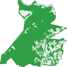
Green: 10 m cells where trees dominate, satellite 2021. Blue: water. The line is the suburb boundary.
| Canopy share, 1 m canopy height map, 2020 | 53.6% |
|---|---|
| Surveyed canopy, Greater Sydney aerial survey, 2019 | 56.8% |
| Land with trees, 10 m satellite map, 2021 | 82.6% |
Demographics
Unemployment 3.4% · Labour-force participation 68.9%
Population by age in Menai
| 0-4 | 594 |
|---|---|
| 5-14 | 1,462 |
| 15-19 | 720 |
| 20-24 | 711 |
| 25-34 | 1,179 |
| 35-44 | 1,290 |
| 45-54 | 1,498 |
| 55-64 | 1,542 |
| 65-74 | 905 |
| 75-84 | 415 |
| 85+ | 107 |
Dwelling types in Menai
| House | 2,583 |
|---|---|
| Townhouse | 739 |
| Apartment | 108 |
| Other | 0 |
Households by weekly income in Menai
| <$650 | 303 |
|---|---|
| $650-1,499 | 588 |
| $1,500-2,999 | 979 |
| $3,000+ | 1,376 |
Top ancestries in Menai
| Australian | 3,720 |
|---|---|
| English | 3,487 |
| Other | 1,282 |
| Irish | 1,060 |
| Scottish | 871 |
| Italian | 645 |
Housing tenure in Menai
| Owned | 1,238 |
|---|---|
| Mortgage | 1,634 |
| Rented | 505 |
| Other | 32 |
Cars per household in Menai
| 0 | 108 |
|---|---|
| 1 | 841 |
| 2 | 1,568 |
| 3 | 531 |
| 4+ | 361 |
Commute to work in Menai
| Car | 2,373 |
|---|---|
| Train | 46 |
| Bus | 8 |
| Tram/ferry | 0 |
| Walked | 55 |
| Bicycle | 0 |
| Home | 2,082 |
Top countries of birth in Menai
| England | 261 |
|---|---|
| China | 150 |
| South Africa | 124 |
| New Zealand | 116 |
| North Macedonia | 91 |
| India | 73 |
Languages used at home in Menai
| Greek | 259 |
|---|---|
| Arabic | 210 |
| Mandarin | 190 |
| Macedonian | 183 |
| Cantonese | 111 |
| Spanish | 103 |
Birds & Wildlife Nearby
64,492 bird observations recorded near Menai — most often seen:
- Rainbow Lorikeet (6,144)
- Sulphur-crested Cockatoo (5,526)
- Noisy Miner (5,268)
- Australian Raven (4,217)
- Australian Magpie (3,517)
- Laughing Kookaburra (3,203)
- Pied Currawong (2,516)
- Grey Butcherbird (2,499)
- Welcome Swallow (2,417)
- Yellow-faced Honeyeater (2,323)
- Magpie-lark (1,797)
- Silvereye (1,783)
- Red Wattlebird (1,782)
Show all 30 birds recorded near Menai
- Australian White Ibis (1,632)
- Masked Lapwing (1,582)
- Eastern Spinebill (1,495)
- Australian Wood Duck (1,484)
- Little Wattlebird (1,410)
- Brown Thornbill (1,388)
- Crimson Rosella (1,286)
- Powerful Owl (1,275)
- Eastern Sulphur-crested Cockatoo (1,203)
- Eastern Rainbow Lorikeet (1,189)
- Australian King-parrot (1,186)
- New Holland Honeyeater (1,165)
- Variegated Fairy-wren (1,098)
- Superb Fairy-wren (1,086)
- Australian Pelican (1,018)
- Spotted Pardalote (1,002)
- Southern Noisy Miner (1,001)
Sightings reported by observers, not a survey, so the counts show what people record rather than what lives here. Source: Atlas of Living Australia.
Nearby Suburbs
The closest suburbs to Menai:
- Bangor (1.9 km)
- Barden Ridge (2.2 km)
- Woronora Heights (2.7 km)
- Illawong (2.9 km)
- Alfords Point (3 km)
- Woronora (3.1 km)
- Bonnet Bay (3.7 km)
- Lucas Heights (4.4 km)
Embed this suburb
Add this free Menai stat card to your own site — just copy the code:
Preview:
Cite this page
Quoting these figures? Copy the credit line:
Keep an eye on Menai
One email when this data meaningfully changes — new census figures, prices, rankings. No spam, unsubscribe anytime.
Streets
- Abraham Close (11)
- Alder Grove (6)
- Alfords Point Road (5)
- Allen Place (25)
- Allison Crescent (265)
- Amberwood Place (24)
- Anderson Place (36)
- Anzac Road (2)
- Appletree Place (30)
- Archer Row (7)
- Arnold Place (30)
- Ashwood Close (7)
- Bachli Place (14)
- Barden Road (3)
- Barnes Crescent (73)
- Barnsley Place (11)
- Barrigon Row (6)
- Barry Road (8)
- Bassett Place (19)
- Batchelor Close (21)
- Beaumaris Drive (79)
- Benaud Close (5)
- Bentley Grove (12)
- Berry Grove (45)
- Berwick Place (11)
- Bishop Road (61)
- Blackthorn Circuit (34)
- Bluegum Way (57)
- Boxsell Close (11)
- Bradman Road (71)
- Bray Grove (16)
- Bromwich Place (24)
- Brown Close (8)
- Burgan Close (2)
- Butler Close (14)
- Carmarthen Street (48)
- Carrol Court (15)
- Carter Road (118)
- Catalpa Grove (33)
- Catton Place (12)
- Charlton Place (16)
- Cherrywood Grove (10)
- Claret Ash Grove (22)
- Clarke Place (4)
- Clothier Road (37)
- Colwyn Close (9)
- Conway Street (15)
- Cottonwood Grove (8)
- Court Place (9)
- Cremin Place (5)
- Cuthbert Place (11)
- Daintree Way (55)
- Davidson Road (24)
- Davis Place (22)
- Dawson Place (13)
- Denbigh Place (24)
- Devlin Place (10)
- Dewberry Close (23)
- Ebony Row (22)
- Elliott Road (48)
- Emerson Place (18)
- Ferguson Close (16)
- Fern Circuit (1)
- Fern Circuit E (18)
- Fern Circuit W (13)
- Ferrier Drive (74)
- Fiddick Place (3)
- Fiddlewood Grove (22)
- Forest Glen Way (13)
- Gerald Road (2)
- Goolagong Place (28)
- Grout Place (7)
- Hall Drive (138)
- Harlech Close (13)
- Harper Way (11)
- Harvey Place (12)
- Hassett Close (13)
- Heathcote Road (3)
- Hilloak Way (21)
- Hopman Avenue (28)
- Jackson Close (10)
- Jacobs Close (25)
- James Close (22)
- Kershaw Road (26)
- Kerslake Grove (10)
- Kilborn Place (24)
- Kippax Place (11)
- Konrads Place (12)
- Landy Close (16)
- Laurel Grove (14)
- Lindwall Close (8)
- Link Circuit (39)
- Llanberis Drive (41)
- Long Close (6)
- Macmahon Place (138)
- Mathers Place (32)
- Mathews Place (22)
- Mayman Row (12)
- Mccabe Place (11)
- Mcgill Place (6)
- Mcgovett Place (5)
- Mckenzie Place (19)
- Meckiff Close (13)
- Menai Road (12)
- Miller Place (36)
- Mina Road (73)
- Mona Road (22)
- Monash Road (109)
- Morris Close (6)
- Nagle Close (5)
- Nevin Close (15)
- Nicolson Circuit (49)
- Noble Close (15)
- O'neill Road (40)
- O'reilly Close (4)
- Oakwood Way (25)
- Old Illawarra Road (163)
- Oldfield Place (26)
- Owen Jones Row (119)
- Parkwood Drive (32)
- Parys Close (27)
- Peachtree Way (16)
- Penmon Close (15)
- Penrose Place (12)
- Pickworth Place (8)
- Pin Oak Grove (8)
- Pioneer Drive (36)
- Poinciana Row (20)
- Popperwell Drive (63)
- Portmadoc Drive (51)
- Power Place (24)
- Quist Place (8)
- Recreation Drive (1)
- Redbush Grove (14)
- Renford Close (6)
- Rosemary Row (9)
- Rosewall Drive (65)
- Rosewood Row (6)
- Royal Row (2)
- Saunders Place (22)
- Schofield Place (312)
- Sedgeman Avenue (32)
- Sequoia Grove (3)
- Silverleaf Row (34)
- Spruce Grove (10)
- St George Crescent (2)
- Stolle Close (4)
- Sycamore Grove (16)
- Talbot Close (8)
- The Woods Circuit (104)
- Tonkies Place (9)
- Travis Place (9)
- Treborth Place (23)
- Treloar Place (15)
- Tristania Grove (8)
- Trumper Place (21)
- Tupelo Grove (13)
- Von Nida Place (17)
- Windle Place (68)
- Yeo Place (5)