Mascot NSW 2020
13,950 addresses · 90 streets
Kingsford Smith Electorate › Bayside LGA › Mascot · 7 km from Sydney
📦 Thinking of moving here? Read the Mascot moving guide

Living Here
An inner-southern Sydney suburb beside the airport that has rapidly densified with new apartments, Mascot is young and well-connected. Households average 2.5 people and the median age is 30. Median household income is $2,254 a week, with rent around $600.
Mascot is a suburb of New South Wales, home to about 21,591 people, with a median age of 30. The typical household earns around $2,254 a week, with median rent near $600 a week. Most homes are apartments. About 41% of households own their home and 58% rent. Most workers work from home. Common community backgrounds include Chinese, English, Australian. On the ABS socio-economic scale it sits in decile 10 of 10 nationally — a relatively advantaged area.
Over time — Census 2001 → 2021
Dashed line: district figures for the Mascot - Eastlakes statistical area (SA2), the smallest area the ABS published before 2011. Solid line: Mascot itself.
Getting Around & Local Services
1 beach
48 Catholic churches
63 hospitals
- Chris O'Brien Lifehouse
- Royal Prince Alfred Hospital
- Women and Babies Services
- Royal Rehab Private Petersham
- Surry Hills Day Hospital
- Emergency Department, Sydney Children's Hospital, Randwick
- Randwick Hospitals Campus
- Sydney Children's Hospital
- Prince of Wales Private Hospital
- Prince Of Wales Loading Dock 5
11 childcare & kindergartens
2 carpenters
Getting around. Train station: Mascot, 350 m north-west · Metro station: Sydenham, 2.5 km north-west · Light rail stop: Kingsford, 3.4 km east · Bus interchange: UTS Shuttle Bus, 1.8 km south-east · Ferry wharf: Blackwattle Bay Wharf, 6 km north · Airport: Sydney (Kingsford Smith) Airport, 2.5 km south.
Socio-economic Standing
Deciles from 1 (lowest) to 10 (highest), against all Australian suburbs. The overall figure weighs advantage and disadvantage together; economic resources counts income and housing, and education & jobs counts qualifications and occupation. They often differ. Source: ABS SEIFA 2021.
Tree cover
🌳 Tree canopy: 2.8% share of land under canopy · satellite map, 2020
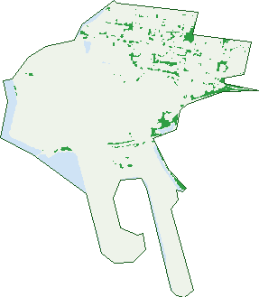
Green: 10 m cells where trees dominate, satellite 2021. Blue: water. The line is the suburb boundary.
| Canopy share, 1 m canopy height map, 2020 | 2.8% |
|---|---|
| Surveyed canopy, Greater Sydney aerial survey, 2019 | 3.7% |
| Land with trees, 10 m satellite map, 2021 | 3.4% |
Demographics
Unemployment 5.9% · Labour-force participation 68.5%
Population by age in Mascot
| 0-4 | 1,138 |
|---|---|
| 5-14 | 1,393 |
| 15-19 | 702 |
| 20-24 | 2,876 |
| 25-34 | 7,408 |
| 35-44 | 3,256 |
| 45-54 | 1,794 |
| 55-64 | 1,394 |
| 65-74 | 917 |
| 75-84 | 522 |
| 85+ | 190 |
Dwelling types in Mascot
| House | 1,704 |
|---|---|
| Townhouse | 320 |
| Apartment | 6,026 |
| Other | 35 |
Households by weekly income in Mascot
| <$650 | 892 |
|---|---|
| $650-1,499 | 1,483 |
| $1,500-2,999 | 2,705 |
| $3,000+ | 2,551 |
Top ancestries in Mascot
| Other | 6,492 |
|---|---|
| Chinese | 5,755 |
| English | 2,830 |
| Australian | 2,415 |
| Irish | 1,503 |
| Ancestry NS | 1,381 |
Housing tenure in Mascot
| Owned | 1,310 |
|---|---|
| Mortgage | 1,978 |
| Rented | 4,597 |
| Other | 98 |
Cars per household in Mascot
| 0 | 1,598 |
|---|---|
| 1 | 4,013 |
| 2 | 1,832 |
| 3 | 373 |
| 4+ | 148 |
Commute to work in Mascot
| Car | 3,327 |
|---|---|
| Train | 939 |
| Bus | 355 |
| Tram/ferry | 3 |
| Walked | 563 |
| Bicycle | 101 |
| Home | 4,586 |
Top countries of birth in Mascot
| China | 2,451 |
|---|---|
| Indonesia | 2,112 |
| India | 554 |
| Ireland | 478 |
| Philippines | 475 |
| England | 450 |
Languages used at home in Mascot
| Mandarin | 2,706 |
|---|---|
| Indonesian | 1,786 |
| Cantonese | 909 |
| Spanish | 812 |
| Greek | 592 |
| Portuguese | 395 |
Birds & Wildlife Nearby
246,656 bird observations recorded near Mascot — most often seen:
- Australian White Ibis (17,867)
- Rainbow Lorikeet (17,358)
- Noisy Miner (14,344)
- Common Myna (11,380)
- Rock Dove (11,166)
- Welcome Swallow (10,997)
- Australian Magpie (10,650)
- Australian Raven (10,533)
- Pied Currawong (10,172)
- Magpie-lark (9,210)
- Pacific Black Duck (8,249)
- Dusky Moorhen (8,074)
- Willie Wagtail (7,966)
Show all 30 birds recorded near Mascot
- Superb Fairy-wren (7,604)
- Spotted Turtle-dove (7,266)
- Common Starling (7,053)
- Little Black Cormorant (7,023)
- Crested Pigeon (6,428)
- White-faced Heron (6,351)
- Chestnut Teal (6,021)
- New Holland Honeyeater (5,731)
- Red Wattlebird (5,667)
- Eurasian Coot (5,446)
- Silver Gull (5,295)
- Red-whiskered Bulbul (5,208)
- Silvereye (5,163)
- Australasian Purple Swamphen (4,958)
- Little Pied Cormorant (4,811)
- Grey Butcherbird (4,454)
- Australasian Figbird (4,211)
Sightings reported by observers, not a survey, so the counts show what people record rather than what lives here. Source: Atlas of Living Australia.
Nearby Suburbs
The closest suburbs to Mascot:
- Rosebery (1.7 km)
- Eastlakes (1.9 km)
- St Peters (1.9 km)
- Beaconsfield (1.9 km)
- Alexandria (2.2 km)
- Sydenham (2.3 km)
- Erskineville (2.5 km)
- Zetland (2.6 km)
Embed this suburb
Add this free Mascot stat card to your own site — just copy the code:
Preview:
Cite this page
Quoting these figures? Copy the credit line:
Keep an eye on Mascot
One email when this data meaningfully changes — new census figures, prices, rankings. No spam, unsubscribe anytime.
Streets
- Alfred Lane (1)
- Alfred Street (88)
- Aloha Street (13)
- Arrival Court (1)
- Arthur Street (16)
- Baxter Road (93)
- Beresford Street (8)
- Botany Lane (23)
- Botany Road (1,250)
- Bourke Road (15)
- Bourke Street (604)
- Bronti Street (15)
- Brussels Street (23)
- Carinya Avenue (84)
- Chalmers Crescent (30)
- Church Avenue (1,342)
- Cleland Street (59)
- Coggins Place (8)
- Coleman Street (6)
- Coward Street (1,919)
- David Street (20)
- Departure Plaza (2)
- Dransfield Avenue (37)
- Duguid Street (3)
- Eleventh Street (1)
- Elizabeth Avenue (24)
- Elphick Avenue (21)
- Etherden Walk (235)
- Ewan Street (23)
- Fifth Street (1)
- Flora Street (18)
- Forster Street (52)
- Francis Street (22)
- Frogmore Lane (1)
- Frogmore Street (83)
- Galloway Street (588)
- Gardeners Road (1,567)
- Gearin Alley (234)
- General Holmes Drive (2)
- Haran Street (180)
- Hardie Lane (1)
- Hardie Street (97)
- Hatfield Street (32)
- Henry Kendall Crescent (46)
- Hicks Avenue (48)
- High Street (395)
- Hollingshed Street (24)
- Horner Avenue (71)
- Hughes Avenue (59)
- Jackson Drive (96)
- John Street (371)
- Johnson Street (112)
- Keith Smith Avenue (1)
- Kent Road (672)
- King Street (598)
- Laycock Street (5)
- Laycock Walk (5)
- Linden Street (53)
- Link Road (6)
- Lyon Street (17)
- Macintosh Street (161)
- Malcolm Street (32)
- Maloney Street (62)
- Mcburney Avenue (54)
- Merchant Street (12)
- Middlemiss Street (57)
- Miles Street (84)
- Muller Lane (340)
- Napoleon Street (49)
- Ney Street (43)
- Ninth Street (1)
- O'riordan Street (700)
- Oliver Street (16)
- Ossary Street (18)
- Picton Street (32)
- Qantas Drive (1)
- Rawson Street (50)
- Ricketty Street (48)
- Robey Street (239)
- Ross Smith Avenue (22)
- Sarah Street (15)
- Seventh Street (6)
- Shiers Avenue (3)
- Sixth Street (1)
- Sparks Street (39)
- Sutherland Street (111)
- Tunbridge Street (170)
- Walker Avenue (22)
- Wellington Street (67)
- Wentworth Avenue (74)