Marrickville NSW 2204
17,467 addresses · 206 streets
Grayndler Electorate › Inner West LGA › Marrickville · 7 km from Sydney
📦 Thinking of moving here? Read the Marrickville moving guide

Living Here
A diverse, creative suburb in Sydney's inner west, Marrickville is known for its food, music and warehouse conversions. Households average 2.3 people and the median age is 37. Median household income is $2,170 a week, with rent around $480.
Marrickville is a suburb of New South Wales, home to about 26,570 people, with a median age of 37. The typical household earns around $2,170 a week, with median rent near $480 a week. Most homes are apartments. About 52% of households own their home and 47% rent. Most workers work from home. Common community backgrounds include English, Australian, Irish. On the ABS socio-economic scale it sits in decile 10 of 10 nationally — a relatively advantaged area.
Over time — Census 2001 → 2021
Dashed line: district figures for the Marrickville statistical area (SA2), the smallest area the ABS published before 2011. Solid line: Marrickville itself.
Getting Around & Local Services
2 carpenters
Getting around. Train station: Tempe, 1.6 km south · Metro station: Marrickville, 400 m south · Light rail stop: Dulwich Hill, 1.3 km west · Bus interchange: UTS Shuttle Bus, 5.3 km south-east · Ferry wharf: Blackwattle Bay Wharf, 5.2 km north-east · Airport: Sydney (Kingsford Smith) Airport, 4.7 km south-east.
Socio-economic Standing
Deciles from 1 (lowest) to 10 (highest), against all Australian suburbs. The overall figure weighs advantage and disadvantage together; economic resources counts income and housing, and education & jobs counts qualifications and occupation. They often differ. Source: ABS SEIFA 2021.
Tree cover
🌳 Tree canopy: 10.7% share of land under canopy · satellite map, 2020
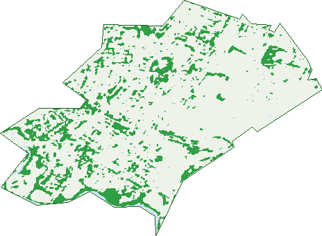
Green: 10 m cells where trees dominate, satellite 2021. Blue: water. The line is the suburb boundary.
| Canopy share, 1 m canopy height map, 2020 | 10.7% |
|---|---|
| Surveyed canopy, Greater Sydney aerial survey, 2019 | 15.1% |
| Land with trees, 10 m satellite map, 2021 | 12.0% |
Demographics
Unemployment 4.6% · Labour-force participation 66%
Population by age in Marrickville
| 0-4 | 1,239 |
|---|---|
| 5-14 | 2,322 |
| 15-19 | 983 |
| 20-24 | 1,607 |
| 25-34 | 5,848 |
| 35-44 | 4,471 |
| 45-54 | 3,639 |
| 55-64 | 2,756 |
| 65-74 | 1,939 |
| 75-84 | 1,263 |
| 85+ | 512 |
Dwelling types in Marrickville
| House | 3,404 |
|---|---|
| Townhouse | 1,969 |
| Apartment | 5,020 |
| Other | 236 |
Households by weekly income in Marrickville
| <$650 | 1,340 |
|---|---|
| $650-1,499 | 2,157 |
| $1,500-2,999 | 3,134 |
| $3,000+ | 3,434 |
Top ancestries in Marrickville
| English | 6,741 |
|---|---|
| Australian | 5,973 |
| Other | 4,701 |
| Irish | 3,166 |
| Greek | 2,337 |
| Scottish | 2,285 |
Housing tenure in Marrickville
| Owned | 2,524 |
|---|---|
| Mortgage | 2,933 |
| Rented | 4,962 |
| Other | 103 |
Cars per household in Marrickville
| 0 | 2,045 |
|---|---|
| 1 | 5,414 |
| 2 | 2,338 |
| 3 | 510 |
| 4+ | 202 |
Commute to work in Marrickville
| Car | 3,415 |
|---|---|
| Train | 549 |
| Bus | 239 |
| Tram/ferry | 23 |
| Walked | 532 |
| Bicycle | 197 |
| Home | 7,257 |
Top countries of birth in Marrickville
| Vietnam | 1,487 |
|---|---|
| Greece | 1,025 |
| England | 891 |
| New Zealand | 530 |
| China | 353 |
| Lebanon | 297 |
Languages used at home in Marrickville
| Greek | 1,849 |
|---|---|
| Vietnamese | 1,836 |
| Arabic | 639 |
| Portuguese | 485 |
| Cantonese | 481 |
| Spanish | 383 |
Birds & Wildlife Nearby
249,546 bird observations recorded near Marrickville — most often seen:
- Rainbow Lorikeet (19,112)
- Australian White Ibis (17,123)
- Noisy Miner (16,221)
- Common Myna (13,148)
- Australian Magpie (11,726)
- Rock Dove (11,453)
- Pied Currawong (10,878)
- Welcome Swallow (10,728)
- Australian Raven (10,304)
- Magpie-lark (9,476)
- Spotted Turtle-dove (8,645)
- Willie Wagtail (7,617)
- Red-whiskered Bulbul (7,224)
Show all 30 birds recorded near Marrickville
- Dusky Moorhen (7,063)
- Superb Fairy-wren (6,865)
- Common Starling (6,478)
- Pacific Black Duck (6,255)
- Silver Gull (6,158)
- Crested Pigeon (6,115)
- White-faced Heron (6,087)
- Chestnut Teal (6,066)
- Grey Butcherbird (5,945)
- Red Wattlebird (5,767)
- Little Black Cormorant (5,567)
- Silvereye (5,388)
- New Holland Honeyeater (5,088)
- Laughing Kookaburra (4,568)
- Sulphur-crested Cockatoo (4,469)
- Australasian Figbird (4,287)
- Little Pied Cormorant (3,725)
Sightings reported by observers, not a survey, so the counts show what people record rather than what lives here. Source: Atlas of Living Australia.
Nearby Suburbs
The closest suburbs to Marrickville:
- Sydenham (1.4 km)
- Tempe (1.5 km)
- Dulwich Hill (1.6 km)
- Petersham (1.7 km)
- Enmore (1.9 km)
- Lewisham (1.9 km)
- St Peters (2.1 km)
- Wolli Creek (2.3 km)
Embed this suburb
Add this free Marrickville stat card to your own site — just copy the code:
Preview:
Cite this page
Quoting these figures? Copy the credit line:
Keep an eye on Marrickville
One email when this data meaningfully changes — new census figures, prices, rankings. No spam, unsubscribe anytime.
Streets
- Addison Road (552)
- Agar Street (57)
- Albermarle Street (27)
- Albion Street (10)
- Alfred Street (22)
- Alma Avenue (2)
- Amy Street (6)
- Anderton Street (39)
- Ann Street (68)
- Arthur Street (381)
- Barclay Street (15)
- Bayley Street (141)
- Beauchamp Street (213)
- Black Street (25)
- Boland Lane (1)
- Bourne Street (38)
- Brereton Avenue (33)
- Brereton Lane (1)
- Bright Street (41)
- Brompton Street (16)
- Bruce Street (6)
- Buckley Street (49)
- Byrnes Street (9)
- Cadogan Street (33)
- Cahill Place (96)
- Calvert Street (61)
- Canterbury Road (1)
- Carrington Road (108)
- Cary Street (108)
- Cavey Street (25)
- Cecilia Street (112)
- Centennial Street (33)
- Central Avenue (25)
- Chadwick Avenue (1)
- Chalder Avenue (12)
- Chalder Street (29)
- Chapel Street (77)
- Charles Street (55)
- Charlotte Avenue (28)
- Church Street (38)
- Cook Road (39)
- Council Street (18)
- Cowper Street (89)
- Crawford Place (7)
- Darley Street (22)
- David Street (33)
- Day Street (64)
- Denby Street (8)
- Despointes Street (118)
- Dibble Avenue (26)
- Dudley Street (54)
- East Street (19)
- Edgeware Road (6)
- Edinburgh Road (257)
- Edward Street (35)
- Elizabeth Street (2)
- Empire Lane (15)
- Enfield Street (89)
- England Avenue (45)
- Enmore Road (135)
- Esk Street (33)
- Essex Street (16)
- Ewart Street (435)
- Excelsior Parade (53)
- Farr Street (41)
- Faversham Street (108)
- Fernbank Street (39)
- Fitzroy Street (96)
- Fletcher Street (38)
- Fotheringham Lane (41)
- Fotheringham Street (5)
- Frampton Avenue (74)
- Francis Street (92)
- Frazer Street (49)
- Garden Street (12)
- Garners Avenue (140)
- George Street (506)
- Gerald Street (27)
- Gladstone Street (32)
- Glen Street (226)
- Gordon Square (18)
- Gordon Street (138)
- Gorman Street (28)
- Graham Avenue (21)
- Greenbank Street (47)
- Grove Street (72)
- Hampden Avenue (3)
- Handley Street (3)
- Harnett Avenue (143)
- Harney Street (16)
- Harriet Street (32)
- Harriett Street (30)
- Harrison Street (32)
- Hastings Street (71)
- Hawkhurst Street (18)
- Henson Street (137)
- High Street (41)
- Hill Street (264)
- Hilltop Avenue (23)
- Hollands Avenue (39)
- Holmesdale Street (53)
- Holts Crescent (2)
- Horton Street (40)
- Illawarra Road (1,890)
- Ivanhoe Street (44)
- Jabez Street (17)
- Jersey Street (43)
- Jocelyn Avenue (15)
- Juliett Lane (2)
- Juliett Street (102)
- Junction Street (18)
- Kays Avenue E (26)
- Lawson Avenue (12)
- Leicester Street (19)
- Leofrene Avenue (37)
- Lilian Fowler Place (66)
- Lilydale Street (103)
- Livingstone Road (914)
- Llewellyn Street (62)
- Malakoff Street (103)
- Mansion Street (14)
- Marrickville Avenue (25)
- Marrickville Road (997)
- Maude Street (4)
- Mcgowan Avenue (15)
- Meeks Lane (1)
- Meeks Road (120)
- Middle Street (49)
- Mitchell Street (20)
- Moncur Street (43)
- Moyes Street (18)
- Murray Street (29)
- Myrtle Street (13)
- Neville Street (114)
- Newington Road (211)
- North Street (56)
- Northcote Street (12)
- O'hara Street (42)
- Osgood Avenue (128)
- Park Road (72)
- Perry Street (80)
- Petersham Road (233)
- Philpott Street (52)
- Pile Street (176)
- Pilgrim Avenue (10)
- Pine Street (67)
- Porter Avenue (24)
- Premier Street (112)
- Princes Street (18)
- Pritchard Street (16)
- Queen Street (33)
- Railway Parade (22)
- Randall Street (17)
- Renwick Street (147)
- Rich Street (25)
- Richards Avenue (18)
- Richardsons Crescent (2)
- Riverdale Avenue (20)
- Riverside Crescent (223)
- Roach Street (27)
- Robert Street (71)
- Roseby Street (49)
- Ruby Street (37)
- Saywell Street (5)
- School Parade (78)
- Schwebel Street (121)
- Scouller Street (35)
- Shelleys Lane (20)
- Shepherd Street (81)
- Shirlow Street (40)
- Silver Street (130)
- Sloane Street (31)
- Smidmore Street (7)
- Smith Street (38)
- South Street (41)
- Stanley Street (9)
- Station Street (28)
- Stoke Avenue (12)
- Surrey Street (27)
- Sydenham Road (283)
- Sydney Steel Road (10)
- Sydney Street (44)
- Tamar Street (21)
- Thompson Street (18)
- Thornley Street (106)
- Tuohy Lane (1)
- Victoria Road (911)
- View Street (89)
- Vincent Street (9)
- Wallace Street (36)
- Warburton Street (18)
- Wardell Road (500)
- Warham Lane (1)
- Warne Place (1)
- Warren Road (337)
- Way Street (2)
- Wemyss Street (43)
- Wharf Street (24)
- Wicks Avenue (16)
- William Street (48)
- Woodbury Street (54)
- Woodcourt Street (143)
- Woodland Street (42)
- Wrights Avenue (49)
- Yabsley Avenue (12)
- York Street (2)