Maroubra NSW 2035
17,279 addresses · 164 streets
Kingsford Smith Electorate › Randwick LGA › Maroubra · 9 km from Sydney
📦 Thinking of moving here? Read the Maroubra moving guide

Living Here
A large eastern-Sydney beachside suburb, Maroubra mixes apartments with family homes near the coast. Households average 2.4 people and the median age is 39. Median household income is $2,141 a week, with rent around $540.
Maroubra is a suburb of New South Wales, home to about 30,722 people, with a median age of 39. The typical household earns around $2,141 a week, with median rent near $540 a week. Most homes are apartments. About 55% of households own their home and 43% rent. Most workers work from home. Common community backgrounds include English, Australian, Chinese. On the ABS socio-economic scale it sits in decile 10 of 10 nationally — a relatively advantaged area.
Over time — Census 2001 → 2021
Dashed line: district figures for the Maroubra statistical area (SA2), the smallest area the ABS published before 2011. Solid line: Maroubra itself.
Getting Around & Local Services
52 schools
- St Aidan's Catholic Primary School
- Maroubra Bay Public School
- St Mary St Joseph Catholic Primary School
- South Sydney High School
- Maroubra Junction Public School
- The International French School of Sydney
- St Spyridon High School
- South Coogee Public School
- Corpus Christi College Maroubra
- Matraville Soldiers' Settlement Public School
32 Catholic churches
- Our Lady of the Annunciation Catholic Church
- St. Agnes’ Catholic Church Matraville
- St. Andrew's Catholic Church
- St Michael's
- St Brigid's Catholic Parish
- The Ascension of Jesus Christ Mausoleum
- Our Lady of the Rosary Church
- Sacred Heart Monastery
- Daughters of Our Lady of the Sacred Heart
- St Therese Catholic Church
2 dog parks
Getting around. Train station: Green Square, 5.7 km north-west · Metro station: Waterloo, 6.6 km north-west · Light rail stop: Juniors Kingsford, 2.5 km north-west · Bus interchange: Juniors Kingsford, 2.5 km north-west · Ferry wharf: Ferry to La Perouse, 7 km south · Airport: Sydney (Kingsford Smith) Airport, 5.9 km west.
Socio-economic Standing
Deciles from 1 (lowest) to 10 (highest), against all Australian suburbs. The overall figure weighs advantage and disadvantage together; economic resources counts income and housing, and education & jobs counts qualifications and occupation. They often differ. Source: ABS SEIFA 2021.
Tree cover
🌳 Tree canopy: 8% share of land under canopy · satellite map, 2020
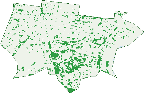
Green: 10 m cells where trees dominate, satellite 2021. Blue: water. The line is the suburb boundary.
| Canopy share, 1 m canopy height map, 2020 | 8.0% |
|---|---|
| Surveyed canopy, Greater Sydney aerial survey, 2019 | 11.0% |
| Land with trees, 10 m satellite map, 2021 | 8.7% |
Demographics
Unemployment 4.6% · Labour-force participation 61.2%
Population by age in Maroubra
| 0-4 | 1,597 |
|---|---|
| 5-14 | 3,332 |
| 15-19 | 1,488 |
| 20-24 | 1,763 |
| 25-34 | 4,858 |
| 35-44 | 4,715 |
| 45-54 | 4,067 |
| 55-64 | 3,399 |
| 65-74 | 2,695 |
| 75-84 | 1,885 |
| 85+ | 927 |
Dwelling types in Maroubra
| House | 3,550 |
|---|---|
| Townhouse | 2,509 |
| Apartment | 5,821 |
| Other | 97 |
Households by weekly income in Maroubra
| <$650 | 1,919 |
|---|---|
| $650-1,499 | 2,241 |
| $1,500-2,999 | 3,130 |
| $3,000+ | 3,939 |
Top ancestries in Maroubra
| English | 6,956 |
|---|---|
| Other | 6,054 |
| Australian | 5,909 |
| Chinese | 3,873 |
| Irish | 3,545 |
| Greek | 2,108 |
Housing tenure in Maroubra
| Owned | 3,565 |
|---|---|
| Mortgage | 2,894 |
| Rented | 5,099 |
| Other | 261 |
Cars per household in Maroubra
| 0 | 1,783 |
|---|---|
| 1 | 5,372 |
| 2 | 3,463 |
| 3 | 804 |
| 4+ | 378 |
Commute to work in Maroubra
| Car | 5,104 |
|---|---|
| Train | 18 |
| Bus | 616 |
| Tram/ferry | 15 |
| Walked | 412 |
| Bicycle | 125 |
| Home | 6,315 |
Top countries of birth in Maroubra
| England | 1,243 |
|---|---|
| China | 1,053 |
| Brazil | 971 |
| Indonesia | 675 |
| Ireland | 582 |
| New Zealand | 491 |
Languages used at home in Maroubra
| Greek | 1,332 |
|---|---|
| Mandarin | 1,204 |
| Cantonese | 1,125 |
| Portuguese | 1,066 |
| French | 860 |
| Spanish | 659 |
Birds & Wildlife Nearby
132,856 bird observations recorded near Maroubra — most often seen:
- Rainbow Lorikeet (10,125)
- Australian White Ibis (7,721)
- Noisy Miner (7,072)
- Welcome Swallow (5,792)
- Australian Raven (5,625)
- Australian Magpie (5,410)
- Common Myna (5,360)
- Pied Currawong (5,223)
- Rock Dove (5,118)
- Superb Fairy-wren (5,044)
- Willie Wagtail (4,721)
- New Holland Honeyeater (4,691)
- Pacific Black Duck (4,614)
Show all 30 birds recorded near Maroubra
- Common Starling (4,561)
- Silver Gull (4,285)
- Dusky Moorhen (3,846)
- Little Black Cormorant (3,779)
- Red Wattlebird (3,756)
- Magpie-lark (3,726)
- Spotted Turtle-dove (3,684)
- Eurasian Coot (3,556)
- Crested Pigeon (3,332)
- Crested Tern (3,040)
- Pied Cormorant (2,965)
- Australasian Grebe (2,686)
- Great Cormorant (2,667)
- Australasian Purple Swamphen (2,623)
- Black Swan (2,621)
- Silvereye (2,619)
- Little Pied Cormorant (2,594)
Sightings reported by observers, not a survey, so the counts show what people record rather than what lives here. Source: Atlas of Living Australia.
Nearby Suburbs
The closest suburbs to Maroubra:
- South Coogee (1.6 km)
- Eastgardens (1.8 km)
- Matraville (1.9 km)
- Hillsdale (1.9 km)
- Pagewood (2.5 km)
- Daceyville (2.6 km)
- Kingsford (2.6 km)
- Banksmeadow (2.8 km)
Embed this suburb
Add this free Maroubra stat card to your own site — just copy the code:
Preview:
Cite this page
Quoting these figures? Copy the credit line:
Keep an eye on Maroubra
One email when this data meaningfully changes — new census figures, prices, rankings. No spam, unsubscribe anytime.
Streets
- Alma Road (138)
- Amour Avenue (18)
- Anzac Parade (1,885)
- Archer Place (4)
- Astoria Circuit (156)
- Avoca Street (9)
- Banks Street (19)
- Beatty Lane (2)
- Beatty Street (18)
- Beauchamp Road (115)
- Beaumond Avenue (69)
- Bell Street (27)
- Bellevue Street (33)
- Bennett Place (22)
- Benvenue Street (26)
- Bona Vista Avenue (160)
- Bond Street (194)
- Boomerang Street (21)
- Bougainville Court (60)
- Bowen Place (18)
- Boyce Lane (4)
- Boyce Road (699)
- Bridges Street (11)
- Broome Street (552)
- Brown Road (52)
- Bruce Bennetts Place (135)
- Bunnerong Road (232)
- Byng Lane (3)
- Byng Street (53)
- Byrne Crescent (28)
- Camira Street (25)
- Cantrill Avenue (30)
- Chapman Avenue (37)
- Charman Avenue (20)
- Chelmsford Avenue (21)
- Chester Avenue (221)
- Chicago Avenue (68)
- Chichester Street (37)
- Cobham Street (43)
- Collier Place (21)
- Cooper Lane (1)
- Cooper Street (89)
- Curtin Crescent (44)
- Dan Avenue (16)
- Davidson Crescent (11)
- Dewey Court (41)
- Donovan Avenue (92)
- Duncan Street (290)
- Eastmore Place (12)
- Edgar Street (77)
- Everett Street (22)
- Farthing Place (6)
- Fenton Avenue (55)
- Ferguson Street (112)
- First Avenue (51)
- Fitzgerald Avenue (406)
- Flower Street (48)
- Foots Place (17)
- Ford Road (68)
- Fowler Crescent (26)
- French Street (99)
- Gale Road (288)
- Galvin Street (36)
- Garden Lane (13)
- Garden Street (239)
- Garrett Street (103)
- Glanfield Street (52)
- Glenugie Street (20)
- Green Street (140)
- Gregory Street (4)
- Haig Street (127)
- Hampson Avenue (23)
- Hannan Lane (8)
- Hannan Street (107)
- Hargraves Place (29)
- Harrison Avenue (14)
- Henning Avenue (13)
- Hereward Street (186)
- Hinkler Street (79)
- Holden Street (24)
- Holmes Street (139)
- Hughes Avenue (26)
- Ian Street (26)
- Inman Street (30)
- Jersey Road (1)
- Johnston Parade (54)
- Keating Street (30)
- Kingsford Street (38)
- Kitchener Street (52)
- Kyogle Street (48)
- Lexington Place (90)
- Liguria Street (20)
- Little Street (38)
- Loch Maree Street (81)
- Lurline Street (12)
- Malabar Road (554)
- Manwaring Avenue (37)
- Marine Parade (492)
- Marjorie Crescent (20)
- Maroubra Road (2,738)
- Mason Street (189)
- Maxwell Avenue (16)
- Mciver Place (27)
- Mckeon Street (223)
- Meagher Avenue (45)
- Mermaid Avenue (60)
- Metcalfe Street (46)
- Midway Drive (109)
- Minneapolis Crescent (209)
- Mons Avenue (197)
- Morris Place (15)
- Moverly Road (132)
- Mulgray Avenue (17)
- Murray Street (12)
- Nagle Avenue (78)
- Neosho Way (2)
- Nevorie Crescent (32)
- New Orleans Crescent (227)
- Nicol Avenue (6)
- O'sullivan Avenue (32)
- Osprey Court (33)
- Paine Street (159)
- Parer Street (49)
- Percival Street (18)
- Perkins Way (16)
- Peters Place (29)
- Piccadilly Place (1)
- Portland Crescent (376)
- Robey Street (210)
- Rodman Avenue (24)
- Ron Filbee Place (6)
- Rossiter Avenue (18)
- Royal Street (71)
- Runic Lane (2)
- Russell Court (20)
- Ryan Avenue (14)
- Sackville Street (65)
- Scott Street (18)
- Second Avenue (33)
- Severn Street (71)
- Shepherd Street (34)
- Sims Grove (49)
- Snape Street (18)
- Storey Street (252)
- Strickland Avenue (1)
- Taylor Street (9)
- The Causeway (74)
- The Corso (47)
- Torrington Road (93)
- Tyrwhitt Street (83)
- Ulm Street (23)
- Undine Street (17)
- Vanny Place (14)
- Wackett Street (38)
- Wade Street (16)
- Walsh Avenue (60)
- Waterside Avenue (12)
- White Avenue (46)
- Wild Lane (6)
- Wild Street (62)
- Wilson Street (33)
- Wise Street (17)
- Wride Street (136)
- Yorktown Parade (332)