Leichhardt NSW 2040
9,897 addresses · 97 streets
Grayndler Electorate › Inner West LGA › Leichhardt · 5 km from Sydney
📦 Thinking of moving here? Read the Leichhardt moving guide

Living Here
An established inner-western Sydney suburb with an Italian heritage along Norton Street, Leichhardt is affluent and well-connected. Households average 2.4 people and the median age is 37. Median household income is high at $2,673 a week, with rent around $600.
Leichhardt is a suburb of New South Wales, home to about 15,158 people, with a median age of 37. The typical household earns around $2,673 a week, with median rent near $600 a week. Most homes are houses. About 58% of households own their home and 41% rent. Most workers work from home. Common community backgrounds include English, Australian, Irish. On the ABS socio-economic scale it sits in decile 10 of 10 nationally — a relatively advantaged area.
Over time — Census 2001 → 2021
Dashed line: district figures for the Leichhardt - Annandale statistical area (SA2), the smallest area the ABS published before 2011. Solid line: Leichhardt itself.
Getting Around & Local Services
24 childcare & kindergartens
2 carpenters
Getting around. Train station: Petersham, 1.2 km south · Metro station: Dulwich Hill, 3.3 km south · Light rail stop: Hawthorne, 800 m north-west · Bus interchange: Mount St (501), 3.9 km north-east · Ferry wharf: Blackwattle Bay Wharf, 3.1 km north-east · Airport: Sydney (Kingsford Smith) Airport, 7.4 km south.
Socio-economic Standing
Deciles from 1 (lowest) to 10 (highest), against all Australian suburbs. The overall figure weighs advantage and disadvantage together; economic resources counts income and housing, and education & jobs counts qualifications and occupation. They often differ. Source: ABS SEIFA 2021.
Tree cover
🌳 Tree canopy: 14.5% share of land under canopy · satellite map, 2020
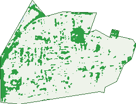
Green: 10 m cells where trees dominate, satellite 2021. Blue: water. The line is the suburb boundary.
| Canopy share, 1 m canopy height map, 2020 | 14.5% |
|---|---|
| Surveyed canopy, Greater Sydney aerial survey, 2019 | 16.5% |
| Land with trees, 10 m satellite map, 2021 | 14.7% |
Demographics
Unemployment 3.7% · Labour-force participation 72%
Population by age in Leichhardt
| 0-4 | 1,014 |
|---|---|
| 5-14 | 1,875 |
| 15-19 | 619 |
| 20-24 | 792 |
| 25-34 | 2,482 |
| 35-44 | 2,792 |
| 45-54 | 2,279 |
| 55-64 | 1,431 |
| 65-74 | 1,069 |
| 75-84 | 543 |
| 85+ | 269 |
Dwelling types in Leichhardt
| House | 2,177 |
|---|---|
| Townhouse | 2,004 |
| Apartment | 1,730 |
| Other | 42 |
Households by weekly income in Leichhardt
| <$650 | 608 |
|---|---|
| $650-1,499 | 996 |
| $1,500-2,999 | 1,475 |
| $3,000+ | 2,617 |
Top ancestries in Leichhardt
| English | 4,948 |
|---|---|
| Australian | 4,145 |
| Other | 2,276 |
| Irish | 2,265 |
| Scottish | 1,610 |
| Italian | 1,563 |
Housing tenure in Leichhardt
| Owned | 1,420 |
|---|---|
| Mortgage | 2,033 |
| Rented | 2,405 |
| Other | 57 |
Cars per household in Leichhardt
| 0 | 809 |
|---|---|
| 1 | 3,157 |
| 2 | 1,583 |
| 3 | 267 |
| 4+ | 85 |
Commute to work in Leichhardt
| Car | 1,909 |
|---|---|
| Train | 63 |
| Bus | 195 |
| Tram/ferry | 20 |
| Walked | 297 |
| Bicycle | 88 |
| Home | 4,728 |
Top countries of birth in Leichhardt
| England | 756 |
|---|---|
| Italy | 371 |
| New Zealand | 362 |
| China | 219 |
| Ireland | 145 |
| United States | 132 |
Languages used at home in Leichhardt
| Italian | 601 |
|---|---|
| Mandarin | 276 |
| Spanish | 267 |
| Greek | 195 |
| Cantonese | 161 |
| Portuguese | 132 |
Birds & Wildlife Nearby
164,984 bird observations recorded near Leichhardt — most often seen:
- Rainbow Lorikeet (16,497)
- Noisy Miner (14,157)
- Australian White Ibis (12,871)
- Rock Dove (10,013)
- Australian Magpie (8,735)
- Common Myna (8,068)
- Pied Currawong (7,350)
- Welcome Swallow (7,268)
- Silver Gull (7,100)
- Australian Raven (6,345)
- Magpie-lark (5,074)
- Crested Pigeon (4,615)
- Spotted Turtle-dove (4,476)
Show all 30 birds recorded near Leichhardt
- Grey Butcherbird (4,430)
- Dusky Moorhen (4,322)
- Pacific Black Duck (3,783)
- Willie Wagtail (3,697)
- Australasian Figbird (3,658)
- Little Black Cormorant (3,469)
- Little Corella (3,190)
- Sulphur-crested Cockatoo (2,930)
- Laughing Kookaburra (2,847)
- White-faced Heron (2,828)
- Masked Lapwing (2,807)
- Australasian Purple Swamphen (2,744)
- Little Pied Cormorant (2,619)
- Common Starling (2,422)
- Red Wattlebird (2,262)
- Southern Noisy Miner (2,209)
- Eurasian Coot (2,198)
Sightings reported by observers, not a survey, so the counts show what people record rather than what lives here. Source: Atlas of Living Australia.
Nearby Suburbs
The closest suburbs to Leichhardt:
- Petersham (1.3 km)
- Lilyfield (1.3 km)
- Lewisham (1.5 km)
- Stanmore (1.5 km)
- Annandale (1.5 km)
- Haberfield (1.5 km)
- Summer Hill (1.8 km)
- Camperdown (2.2 km)
Embed this suburb
Add this free Leichhardt stat card to your own site — just copy the code:
Preview:
Cite this page
Quoting these figures? Copy the credit line:
Keep an eye on Leichhardt
One email when this data meaningfully changes — new census figures, prices, rankings. No spam, unsubscribe anytime.
Streets
- Ainsworth Street (2)
- Albert Street (81)
- Albion Street (4)
- Allen Street (354)
- Annesley Street (88)
- Arthur Street (58)
- Athol Street (31)
- Balmain Road (228)
- Beeson Street (67)
- Bungay Street (23)
- Burfitt Street (181)
- Canal Road (9)
- Carlisle Street (198)
- Cary Street (69)
- Catherine Street (301)
- Charles Street (69)
- Coleridge Street (51)
- Cromwell Street (47)
- Daniel Street (55)
- Darley Road (46)
- Davies Street (30)
- Day Street (124)
- Derbyshire Road (68)
- Edith Lane (1)
- Edith Street (185)
- Elswick Street (281)
- Elswick Street N (66)
- Emily Street (33)
- Emma Street (72)
- Excelsior Street (60)
- Falls Street (41)
- Flat Street (33)
- Flood Street (658)
- Foster Street (168)
- Fowler Street (15)
- Francis Street (103)
- George Street (375)
- Hathern Street (29)
- Hawthorne Street (18)
- Hay Street (142)
- Hearn Street (32)
- Henry Street (80)
- Hill Street (93)
- Hubert Street (73)
- Ivory Lane (25)
- Ivory Street (1)
- James Street (161)
- Jarrett Lane (1)
- Jarrett Street (97)
- John Street (107)
- Junior Street (62)
- Kalgoorlie Street (42)
- Kegworth Street (27)
- Leichhardt Street (90)
- Loftus Street (19)
- Lords Road (75)
- Lyall Street (57)
- Macauley Street (142)
- Mackenzie Street (74)
- Macquarie Street (45)
- Marion Street (689)
- Marlborough Street (96)
- Mcdonald Street (40)
- Milton Street (22)
- Moore Lane (1)
- Moore Street (205)
- Myrtle Lane (5)
- Myrtle Street (50)
- National Street (39)
- North Avenue (61)
- North Street (88)
- Norton Street (982)
- Parramatta Road (456)
- Pine Square (1)
- Prospect Street (26)
- Redmond Street (51)
- Regent Street (2)
- Renwick Street (157)
- Reuss Street (50)
- Rofe Street (84)
- Roseby Street (27)
- Seale Street (23)
- Short Street (76)
- Skelton Street (14)
- South Avenue (54)
- Stanley Street (39)
- Styles Street (65)
- Tebbutt Street (90)
- Thorby Avenue (41)
- Thornley Street (61)
- Upward Street (207)
- Walter Street (26)
- Waratah Street (35)
- Wetherill Street (79)
- Whites Creek Lane (21)
- Whiting Street (60)
- William Street (107)