Kingscliff NSW 2487
6,572 addresses · 115 streets
Richmond Electorate › Tweed LGA › Kingscliff · 663 km from Sydney
📦 Thinking of moving here? Read the Kingscliff moving guide

Living Here
Kingscliff is a suburb of New South Wales, home to about 8,355 people, with a median age of 47. The typical household earns around $1,575 a week, with median rent near $490 a week. Most homes are houses. About 70% of households own their home and 29% rent. Most workers drive to work. Common community backgrounds include English, Australian, Irish. On the ABS socio-economic scale it sits in decile 8 of 10 nationally — a relatively advantaged area.
Over time — Census 2001 → 2021
Dashed line: district figures for the Kingscliff - Fingal Head statistical area (SA2), the smallest area the ABS published before 2011. Solid line: Kingscliff itself.
Getting Around & Local Services
1 supermarket
1 beach
1 Catholic church
1 medical clinic
2 dentists
1 physiotherapist
1 vet
1 library
1 post office
2 service stations
2 gyms & sports centres
1 butcher
Getting around. Airport: Gold Coast Airport, 12.2 km north-west.
Socio-economic Standing
Deciles from 1 (lowest) to 10 (highest), against all Australian suburbs. The overall figure weighs advantage and disadvantage together; economic resources counts income and housing, and education & jobs counts qualifications and occupation. They often differ. Source: ABS SEIFA 2021.
Tree cover
🌳 Tree canopy: 20.2% share of land under canopy · satellite map, 2020
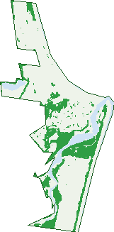
Green: 10 m cells where trees dominate, satellite 2021. Blue: water. The line is the suburb boundary.
| Canopy share, 1 m canopy height map, 2020 | 20.2% |
|---|---|
| Land with trees, 10 m satellite map, 2021 | 25.1% |
Demographics
Unemployment 3.9% · Labour-force participation 56.1%
Population by age in Kingscliff
| 0-4 | 384 |
|---|---|
| 5-14 | 1,076 |
| 15-19 | 448 |
| 20-24 | 324 |
| 25-34 | 639 |
| 35-44 | 982 |
| 45-54 | 1,129 |
| 55-64 | 1,238 |
| 65-74 | 1,173 |
| 75-84 | 661 |
| 85+ | 298 |
Dwelling types in Kingscliff
| House | 1,971 |
|---|---|
| Townhouse | 549 |
| Apartment | 666 |
| Other | 5 |
Households by weekly income in Kingscliff
| <$650 | 544 |
|---|---|
| $650-1,499 | 875 |
| $1,500-2,999 | 829 |
| $3,000+ | 694 |
Top ancestries in Kingscliff
| English | 3,856 |
|---|---|
| Australian | 3,133 |
| Irish | 1,336 |
| Scottish | 1,038 |
| Other | 601 |
| Ancestry NS | 442 |
Housing tenure in Kingscliff
| Owned | 1,348 |
|---|---|
| Mortgage | 855 |
| Rented | 903 |
| Other | 42 |
Cars per household in Kingscliff
| 0 | 145 |
|---|---|
| 1 | 1,281 |
| 2 | 1,272 |
| 3 | 296 |
| 4+ | 165 |
Commute to work in Kingscliff
| Car | 2,237 |
|---|---|
| Train | 0 |
| Bus | 22 |
| Tram/ferry | 0 |
| Walked | 113 |
| Bicycle | 30 |
| Home | 763 |
Top countries of birth in Kingscliff
| England | 423 |
|---|---|
| New Zealand | 232 |
| South Africa | 45 |
| Scotland | 44 |
| United States | 41 |
| Canada | 38 |
Languages used at home in Kingscliff
| Portuguese | 29 |
|---|---|
| French | 24 |
| Japanese | 23 |
| German | 20 |
| Italian | 20 |
| Spanish | 18 |
Birds & Wildlife Nearby
33,844 bird observations recorded near Kingscliff — most often seen:
- Australian White Ibis (2,050)
- Silver Gull (1,632)
- Noisy Miner (1,377)
- Little Black Cormorant (1,355)
- Welcome Swallow (1,349)
- Australian Magpie (1,335)
- Pacific Black Duck (1,314)
- Masked Lapwing (1,265)
- Magpie-lark (1,208)
- Australasian Figbird (1,200)
- Australian Pelican (1,196)
- Rainbow Lorikeet (1,189)
- Willie Wagtail (1,166)
Show all 30 birds recorded near Kingscliff
- Torresian Crow (1,163)
- Australian Wood Duck (1,151)
- Pied Currawong (1,132)
- Brown Honeyeater (1,123)
- Noisy Friarbird (1,034)
- Rainbow Bee-eater (960)
- White-faced Heron (954)
- Crested Tern (949)
- Giinbaywarraymal (903)
- Little Pied Cormorant (902)
- Crested Pigeon (875)
- Dusky Moorhen (870)
- Laughing Kookaburra (865)
- Pied Butcherbird (864)
- Lewin's Honeyeater (841)
- Australian Brush-turkey (837)
- Superb Fairy-wren (785)
Sightings reported by observers, not a survey, so the counts show what people record rather than what lives here. Source: Atlas of Living Australia.
Nearby Suburbs
The closest suburbs to Kingscliff:
- Cudgen (1.7 km)
- Chinderah (3.3 km)
- Kings Forest (3.8 km)
- Casuarina (4.2 km)
- Banora Point (5.9 km)
- Duranbah (6 km)
- Stotts Creek (6.4 km)
- Fingal Head (6.7 km)
Embed this suburb
Add this free Kingscliff stat card to your own site — just copy the code:
Preview:
Cite this page
Quoting these figures? Copy the credit line:
Keep an eye on Kingscliff
One email when this data meaningfully changes — new census figures, prices, rankings. No spam, unsubscribe anytime.
Streets
- Alley Way (1)
- Angourie Street (20)
- Avoca Street (36)
- Banzai Street (24)
- Barrel Street (14)
- Baswyn Mews (2)
- Beach Street (98)
- Bellbird Drive (18)
- Bells Boulevard (662)
- Blue Jay Circuit (102)
- Bondi Place (13)
- Boomerang Street (108)
- Bradshaw Place (4)
- Bronte Place (25)
- Bundeena Street (19)
- Cactus Court (12)
- Cambridge Court (24)
- Castaway Lane (6)
- Casuarina Way (83)
- Cathedral Court (24)
- Channel Place (33)
- Cormorant Place (23)
- Cronulla Court (5)
- Cudgen Road (48)
- Cylinders Drive (178)
- Dawes Avenue (27)
- Dinsey Street (26)
- Dove Close (6)
- Drift Court (37)
- Eddy Avenue (13)
- Edgewater Lane (11)
- Elliston Street (21)
- Elrond Drive (74)
- Fairy Bower Street (22)
- Faulks Street (18)
- Forresters Court (7)
- Forster Avenue (5)
- Gaggin Way (23)
- Gibson Street (54)
- Gunnamatta Avenue (284)
- Herford Street (17)
- Hungerford Lane (113)
- Ibis Court (14)
- Indigo Lane (1)
- Julius Place (6)
- Kindee Street (20)
- Kingfisher Circuit (39)
- Kingscliff Lane (5)
- Kingscliff Street (386)
- Knox Court (8)
- Longboard Circuit (48)
- Lorien Way (93)
- Malibu Street (18)
- Marine Parade (895)
- Mckissock Drive (1)
- Mcphail Avenue (53)
- Mistletoe Circuit (65)
- Monarch Drive (297)
- Moss Street (131)
- Murphys Road (115)
- Narrabeen Street (17)
- Nautilus Way (105)
- North Point Avenue (48)
- Oasis Way (2)
- Ocean Avenue (36)
- Ocean Drive (1)
- Ocean Street (44)
- Oceanview Crescent (47)
- Olga Street (24)
- Omar Street (5)
- Orient Lane (5)
- Orient Street (58)
- Oriole Lane (6)
- Osprey Place (19)
- Oxford Street (31)
- Ozone Street (28)
- Pacific Street (12)
- Palmers Lane (4)
- Pearl Street (328)
- Peate Court (23)
- Pitta Court (6)
- Point Break Circuit (20)
- Quail Place (12)
- Quigan Street (26)
- Quirk Place (11)
- Rob Roy Crescent (17)
- Sailfish Way (105)
- Salt Water Crescent (42)
- Sand Street (78)
- Sandbank Place (17)
- Seaside Drive (134)
- Seaview Street (77)
- Shell Street (18)
- Shipstern Street (19)
- Shoal Place (37)
- Shore Place (27)
- Snapper Avenue (25)
- Spoonbill Lane (14)
- Sunfish Lane (12)
- Surf Street (57)
- Sutherland Street (117)
- Tallows Avenue (20)
- Tamarama Drive (13)
- Terrace Street (43)
- Turnock Street (1)
- Ulladulla Court (16)
- Valiant Street (24)
- Viking Street (26)
- Vulcan Street (81)
- Windsong Way (1)
- Wommin Bay Road (20)
- Woram Place (10)
- Yale Street (18)
- Yao Street (30)
- Zephyr Street (20)