Killara NSW 2071
4,939 addresses · 94 streets
Bradfield Electorate › Ku-ring-gai LGA › Killara · 12 km from Sydney
📦 Thinking of moving here? Read the Killara moving guide

Living Here
Killara is a suburb of New South Wales, home to about 10,620 people, with a median age of 42. The typical household earns around $2,802 a week, with median rent near $620 a week. Most homes are houses. About 72% of households own their home and 26% rent. Most workers work from home. Common community backgrounds include Chinese, English, Australian. On the ABS socio-economic scale it sits in decile 10 of 10 nationally — a relatively advantaged area.
Over time — Census 2001 → 2021
Dashed line: district figures for the Gordon - Killara statistical area (SA2), the smallest area the ABS published before 2011. Solid line: Killara itself.
Getting Around & Local Services
11 childcare & kindergartens
2 playgrounds
2 electricians
Getting around. Train station: Killara, 300 m north-east · Metro station: Macquarie Park, 3.5 km south-west · Bus interchange: Gordon Interchange, 1.2 km north · Ferry wharf: Riverview College Wharf, 7 km south · Airport: Rose Bay Seaplane Base, 15 km south-east.
Socio-economic Standing
Deciles from 1 (lowest) to 10 (highest), against all Australian suburbs. The overall figure weighs advantage and disadvantage together; economic resources counts income and housing, and education & jobs counts qualifications and occupation. They often differ. Source: ABS SEIFA 2021.
Tree cover
🌳 Tree canopy: 29.7% share of land under canopy · satellite map, 2020
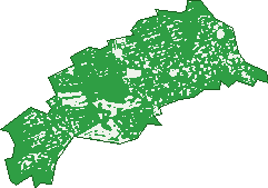
Green: 10 m cells where trees dominate, satellite 2021. Blue: water. The line is the suburb boundary.
| Canopy share, 1 m canopy height map, 2020 | 29.7% |
|---|---|
| Surveyed canopy, Greater Sydney aerial survey, 2019 | 42.6% |
| Land with trees, 10 m satellite map, 2021 | 89.4% |
Demographics
Unemployment 4.7% · Labour-force participation 59.6%
Population by age in Killara
| 0-4 | 425 |
|---|---|
| 5-14 | 1,502 |
| 15-19 | 833 |
| 20-24 | 660 |
| 25-34 | 893 |
| 35-44 | 1,377 |
| 45-54 | 1,640 |
| 55-64 | 1,292 |
| 65-74 | 984 |
| 75-84 | 651 |
| 85+ | 366 |
Dwelling types in Killara
| House | 2,020 |
|---|---|
| Townhouse | 105 |
| Apartment | 1,575 |
| Other | 0 |
Households by weekly income in Killara
| <$650 | 327 |
|---|---|
| $650-1,499 | 584 |
| $1,500-2,999 | 893 |
| $3,000+ | 1,650 |
Top ancestries in Killara
| Chinese | 3,303 |
|---|---|
| English | 2,627 |
| Australian | 2,072 |
| Other | 1,393 |
| Irish | 798 |
| Scottish | 730 |
Housing tenure in Killara
| Owned | 1,456 |
|---|---|
| Mortgage | 1,193 |
| Rented | 939 |
| Other | 85 |
Cars per household in Killara
| 0 | 190 |
|---|---|
| 1 | 1,460 |
| 2 | 1,460 |
| 3 | 367 |
| 4+ | 187 |
Commute to work in Killara
| Car | 1,320 |
|---|---|
| Train | 155 |
| Bus | 6 |
| Tram/ferry | 0 |
| Walked | 48 |
| Bicycle | 9 |
| Home | 2,699 |
Top countries of birth in Killara
| China | 1,467 |
|---|---|
| England | 453 |
| Hong Kong | 428 |
| South Korea | 282 |
| India | 233 |
| South Africa | 194 |
Languages used at home in Killara
| Mandarin | 1,838 |
|---|---|
| Cantonese | 827 |
| Korean | 361 |
| Hindi | 118 |
| Japanese | 110 |
| Spanish | 97 |
Birds & Wildlife Nearby
82,362 bird observations recorded near Killara — most often seen:
- Rainbow Lorikeet (8,820)
- Sulphur-crested Cockatoo (7,256)
- Noisy Miner (6,388)
- Laughing Kookaburra (5,622)
- Australian Magpie (4,225)
- Australian Brush-turkey (4,180)
- Pied Currawong (3,476)
- Australian Raven (3,001)
- Eastern Spinebill (2,875)
- Grey Butcherbird (2,669)
- Yellow-faced Honeyeater (2,551)
- Australian King-parrot (2,303)
- Australian Wood Duck (2,253)
Show all 30 birds recorded near Killara
- Eastern Whipbird (2,047)
- White-browed Scrubwren (2,044)
- Eastern Yellow Robin (2,009)
- Welcome Swallow (1,859)
- Brown Thornbill (1,778)
- Crimson Rosella (1,667)
- Galah (1,664)
- Grey Fantail (1,482)
- Tawny Frogmouth (1,469)
- Superb Fairy-wren (1,456)
- Pacific Black Duck (1,391)
- Dusky Moorhen (1,369)
- Lewin's Honeyeater (1,347)
- Common Myna (1,312)
- Silvereye (1,296)
- Brown Gerygone (1,282)
- Spotted Pardalote (1,271)
Sightings reported by observers, not a survey, so the counts show what people record rather than what lives here. Source: Atlas of Living Australia.
Nearby Suburbs
The closest suburbs to Killara:
- Lindfield (1.4 km)
- Gordon (1.5 km)
- East Killara (2.2 km)
- West Pymble (2.7 km)
- East Lindfield (2.8 km)
- Roseville (2.9 km)
- Pymble (3 km)
- Chatswood West (3.2 km)
Embed this suburb
Add this free Killara stat card to your own site — just copy the code:
Preview:
Cite this page
Quoting these figures? Copy the credit line:
Keep an eye on Killara
One email when this data meaningfully changes — new census figures, prices, rankings. No spam, unsubscribe anytime.
Streets
- Albert Drive (88)
- Anembo Crescent (14)
- Arnold Street (88)
- Arthur Street (18)
- Banyula Place (9)
- Beaumont Road (55)
- Bell Street (2)
- Bimbil Place (7)
- Birdwood Avenue (12)
- Blaxland Road (40)
- Bowes Avenue (24)
- Bruce Avenue (228)
- Buckingham Road (172)
- Caithness Street (7)
- Calvert Avenue (34)
- Cecil Street (1)
- Charles Street (33)
- Clarence Avenue (6)
- Clarke Place (15)
- Clopton Drive (6)
- Cook Road (39)
- Coronga Crescent (55)
- Culworth Avenue (243)
- De Burgh Road (8)
- Eastern Arterial Road (19)
- Ellsmore Avenue (21)
- Elva Avenue (39)
- Essex Street (46)
- Eustace Parade (33)
- Fiddens Wharf Road (130)
- Fitzroy Street (20)
- Forsyth Street (21)
- Frederick Street (20)
- Garnet Crescent (6)
- Garnet Street (17)
- Gleneagles Avenue (31)
- Golf Links Road (12)
- Grassmere Road (37)
- Greengate Lane (2)
- Greengate Road (105)
- Gurin Avenue (14)
- Highbridge Road (16)
- Horwood Avenue (4)
- Illeroy Avenue (42)
- Kalang Avenue (14)
- Kardella Avenue (30)
- Karranga Avenue (32)
- Kiamala Crescent (14)
- Killara Avenue (118)
- Kittani Place (9)
- Koola Avenue (12)
- Kylie Avenue (33)
- Lady Game Drive (36)
- Lagonda Avenue (5)
- Laing Avenue (11)
- Locksley Street (19)
- Lorne Avenue (254)
- Lynwood Avenue (33)
- Lyon Close (6)
- Maitland Street (16)
- Manning Road (37)
- Maples Avenue (6)
- Marian Street (244)
- Maytone Avenue (18)
- Mcintosh Street (1)
- Mildura Street (12)
- Montah Avenue (21)
- Montreal Avenue (20)
- Moore Avenue (1)
- Nelson Road (11)
- Norfolk Street (60)
- Northcote Avenue (39)
- Nyora Street (9)
- Pacific Highway (807)
- Powell Street (96)
- Prince Road (12)
- Provincial Road (1)
- Quebec Avenue (17)
- Redbank Road (11)
- Redgum Avenue (18)
- Ridgeland Avenue (15)
- Rosebery Road (57)
- Rosetta Avenue (17)
- Sarnia Crescent (6)
- Spencer Road (159)
- Springdale Road (143)
- Stanhope Road (395)
- Tasman Crescent (5)
- Terrace Road (39)
- The Crest (17)
- Wallaroo Close (44)
- Warwick Street (50)
- Wattle Street (39)
- Werona Avenue (31)