Kiama NSW 2533
5,779 addresses · 122 streets
Gilmore Electorate › Kiama LGA › Kiama · 96 km from Sydney
📦 Thinking of moving here? Read the Kiama moving guide

Living Here
Kiama is a suburb of New South Wales, home to about 7,904 people, with a median age of 52. The typical household earns around $1,572 a week, with median rent near $478 a week. Most homes are houses. About 72% of households own their home and 23% rent. Most workers drive to work. Common community backgrounds include English, Australian, Irish. On the ABS socio-economic scale it sits in decile 9 of 10 nationally — a relatively advantaged area.
Over time — Census 2001 → 2021
Dashed line: district figures for the Kiama statistical area (SA2), the smallest area the ABS published before 2011. Solid line: Kiama itself.
Getting Around & Local Services
1 supermarket
2 Catholic churches
2 pharmacies
4 doctors & medical clinics
2 optometrists
1 vet
1 library
1 post office
1 service station
3 gyms & sports centres
1 butcher
2 beauty salons
Getting around. Train station: Kiama, 500 m north-east · Airport: Shellharbour Airport, 13.9 km north-west.
Socio-economic Standing
Deciles from 1 (lowest) to 10 (highest), against all Australian suburbs. The overall figure weighs advantage and disadvantage together; economic resources counts income and housing, and education & jobs counts qualifications and occupation. They often differ. Source: ABS SEIFA 2021.
Tree cover
🌳 Tree canopy: 16.6% share of land under canopy · satellite map, 2020
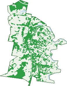
Green: 10 m cells where trees dominate, satellite 2021. Blue: water. The line is the suburb boundary.
| Canopy share, 1 m canopy height map, 2020 | 16.6% |
|---|---|
| Land with trees, 10 m satellite map, 2021 | 40.3% |
Demographics
Unemployment 3.9% · Labour-force participation 49.6%
Population by age in Kiama
| 0-4 | 348 |
|---|---|
| 5-14 | 797 |
| 15-19 | 356 |
| 20-24 | 297 |
| 25-34 | 719 |
| 35-44 | 792 |
| 45-54 | 861 |
| 55-64 | 1,178 |
| 65-74 | 1,302 |
| 75-84 | 868 |
| 85+ | 385 |
Dwelling types in Kiama
| House | 1,795 |
|---|---|
| Townhouse | 780 |
| Apartment | 621 |
| Other | 36 |
Households by weekly income in Kiama
| <$650 | 561 |
|---|---|
| $650-1,499 | 910 |
| $1,500-2,999 | 905 |
| $3,000+ | 681 |
Top ancestries in Kiama
| English | 3,501 |
|---|---|
| Australian | 2,900 |
| Irish | 1,230 |
| Scottish | 984 |
| Other | 542 |
| Ancestry NS | 457 |
Housing tenure in Kiama
| Owned | 1,470 |
|---|---|
| Mortgage | 828 |
| Rented | 726 |
| Other | 162 |
Cars per household in Kiama
| 0 | 168 |
|---|---|
| 1 | 1,273 |
| 2 | 1,275 |
| 3 | 313 |
| 4+ | 169 |
Commute to work in Kiama
| Car | 1,669 |
|---|---|
| Train | 16 |
| Bus | 4 |
| Tram/ferry | 0 |
| Walked | 111 |
| Bicycle | 9 |
| Home | 871 |
Top countries of birth in Kiama
| England | 500 |
|---|---|
| New Zealand | 114 |
| United States | 68 |
| Scotland | 62 |
| Germany | 54 |
| China | 51 |
Languages used at home in Kiama
| Mandarin | 38 |
|---|---|
| Spanish | 37 |
| Greek | 35 |
| German | 29 |
| Cantonese | 28 |
| Italian | 23 |
Birds & Wildlife Nearby
61,763 bird observations recorded near Kiama — most often seen:
- Australian Magpie (3,890)
- Australian Raven (3,888)
- Magpie-lark (3,404)
- Superb Fairy-wren (2,800)
- Lewin's Honeyeater (2,637)
- Rainbow Lorikeet (2,417)
- Willie Wagtail (2,412)
- Welcome Swallow (2,198)
- Satin Bowerbird (2,137)
- White-faced Heron (2,063)
- Grey Fantail (2,055)
- Eastern Whipbird (2,002)
- Red-whiskered Bulbul (1,975)
Show all 30 birds recorded near Kiama
- Pacific Black Duck (1,952)
- Silvereye (1,916)
- Galah (1,867)
- Eastern Spinebill (1,826)
- Common Myna (1,773)
- Laughing Kookaburra (1,740)
- Little Pied Cormorant (1,659)
- Common Starling (1,658)
- Eastern Yellow Robin (1,589)
- Crimson Rosella (1,574)
- Silver Gull (1,534)
- Australian White Ibis (1,524)
- Brown Thornbill (1,504)
- Pied Currawong (1,485)
- Red-browed Finch (1,479)
- Straw-necked Ibis (1,431)
- Brown Gerygone (1,374)
Sightings reported by observers, not a survey, so the counts show what people record rather than what lives here. Source: Atlas of Living Australia.
Nearby Suburbs
The closest suburbs to Kiama:
- Kiama Heights (2.3 km)
- Bombo (2.5 km)
- Jerrara (2.8 km)
- Kiama Downs (3.6 km)
- Saddleback Mountain (5 km)
- Minnamurra (5.4 km)
- Rose Valley (6 km)
- Werri Beach (6.7 km)
Embed this suburb
Add this free Kiama stat card to your own site — just copy the code:
Preview:
Cite this page
Quoting these figures? Copy the credit line:
Keep an eye on Kiama
One email when this data meaningfully changes — new census figures, prices, rankings. No spam, unsubscribe anytime.
Streets
- Adina Avenue (7)
- Akuna Street (14)
- Alison Street (11)
- Allambie Crescent (11)
- Antrim Street (26)
- Arnold Crescent (35)
- Banksia Drive (30)
- Barney Street (108)
- Bele Place (51)
- Belvedere Street (86)
- Blair Street (9)
- Bland Street (90)
- Blowhole Point Road (3)
- Boanyo Avenue (64)
- Bonaira Street (123)
- Bong Bong Street (141)
- Bourrool Lane (29)
- Bourrool Street (36)
- Brighton Street (14)
- Brown Street (94)
- Caliope Street (16)
- Cedar Ridge Road (70)
- Chapman Street (30)
- Charmian Clift Place (16)
- Claremont Place (7)
- Coachwood Street (15)
- Cole Street (49)
- Colley Drive (29)
- Collins Lane (20)
- Collins Street (184)
- Cooinda Place (85)
- Coryule Place (14)
- Danube Street (22)
- Devonshire Street (6)
- Dido Street (36)
- Downey Street (2)
- Dudgeon Street (10)
- Eastern View Place (6)
- Eddy Street (15)
- Elimatta Place (34)
- Elouera Place (14)
- Eugene Street (9)
- Evans Place (11)
- Fadden Street (31)
- Farmer Street (65)
- Finlayson Avenue (3)
- Fitzroy Street (5)
- Garden Avenue (22)
- Gipps Street (52)
- Girrawheen Avenue (55)
- Glenbrook Drive (42)
- Greyleigh Drive (22)
- Gura Street (10)
- Gwinganna Avenue (68)
- Hanrahan Place (11)
- Hartwell Crescent (9)
- Havilah Place (32)
- Henley Avenue (22)
- Henry Kendall Place (12)
- Hillingdon Crescent (14)
- Hillview Circuit (113)
- Holden Avenue (46)
- Holden Place (15)
- Hothersal Street (74)
- Hothersal Street S (2)
- Hutchinson Street (1)
- Irvine Street (50)
- Isabella Place (24)
- Jamberoo Road (12)
- James Lane (14)
- Jerrara Avenue (19)
- Kaleula Crescent (28)
- Kendall Street (7)
- Keppel Street (5)
- King Street (16)
- Lilly Pilly Way (33)
- Lockett Place (4)
- Love Street (30)
- Manning Street (592)
- Marks Street (48)
- Marsden Street (79)
- Mcfaul Place (14)
- Meares Place (75)
- Melia Street (14)
- Merrick Circuit (67)
- Minnamurra Street (179)
- Myuna Place (13)
- Noorinan Street (43)
- O'keefe Place (12)
- Ocean Street (9)
- Old Saddleback Road (96)
- Orana Avenue (15)
- Pacific Street (32)
- Pheasant Point Drive (43)
- Pike Place (12)
- Price Avenue (22)
- Pullen Place (5)
- Railway Parade (20)
- Reid Street (73)
- Riversdale Road (4)
- Saddleback Mountain Road (53)
- Seaview Street (23)
- Shoalhaven Street (289)
- Sommerville Close (10)
- South Kiama Drive (46)
- Spring Creek Drive (3)
- Stewart Place (21)
- Stobo Road (1)
- Surfleet Place (156)
- Swan Place (32)
- Tanner Place (19)
- Taylor Street (50)
- Terralong Street (518)
- Tharkinna Avenue (29)
- Thomson Street (164)
- Tingira Crescent (117)
- Tombonda Drive (52)
- Turpentine Street (6)
- Weston Place (19)
- Whitton Place (24)
- William Street (16)
- Wilson Street (14)