Katoomba NSW 2780
7,054 addresses · 200 streets
Macquarie Electorate › Blue Mountains LGA › Katoomba · 85 km from Sydney
📦 Thinking of moving here? Read the Katoomba moving guide

Living Here
Katoomba is a suburb of New South Wales, home to about 8,268 people, with a median age of 48. The typical household earns around $1,171 a week, with median rent near $350 a week. Most homes are houses. About 65% of households own their home and 34% rent. Most workers drive to work. Common community backgrounds include English, Australian, Irish. On the ABS socio-economic scale it sits in decile 4 of 10 nationally — a mid-range area.
Over time — Census 2001 → 2021
Dashed line: district figures for the Katoomba - Leura statistical area (SA2), the smallest area the ABS published before 2011. Solid line: Katoomba itself.
Getting Around & Local Services
3 Catholic churches
3 optometrists
2 libraries
2 post offices
1 butcher
3 hardware stores
2 beauty salons
1 carpenter
Getting around. Train station: Katoomba, 50 m north-east · Airport: Western Sydney International Airport, 41.9 km south-east.
Socio-economic Standing
Deciles from 1 (lowest) to 10 (highest), against all Australian suburbs. The overall figure weighs advantage and disadvantage together; economic resources counts income and housing, and education & jobs counts qualifications and occupation. They often differ. Source: ABS SEIFA 2021.
Tree cover
🌳 Tree canopy: 57.6% share of land under canopy · satellite map, 2020
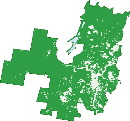
Green: 10 m cells where trees dominate, satellite 2021. Blue: water. The line is the suburb boundary.
| Canopy share, 1 m canopy height map, 2020 | 57.6% |
|---|---|
| Surveyed canopy, Greater Sydney aerial survey, 2019 | 61.0% |
| Land with trees, 10 m satellite map, 2021 | 90.3% |
Demographics
Unemployment 6% · Labour-force participation 53.1%
Population by age in Katoomba
| 0-4 | 316 |
|---|---|
| 5-14 | 826 |
| 15-19 | 410 |
| 20-24 | 360 |
| 25-34 | 857 |
| 35-44 | 1,035 |
| 45-54 | 1,270 |
| 55-64 | 1,256 |
| 65-74 | 1,284 |
| 75-84 | 520 |
| 85+ | 142 |
Dwelling types in Katoomba
| House | 3,076 |
|---|---|
| Townhouse | 214 |
| Apartment | 412 |
| Other | 27 |
Households by weekly income in Katoomba
| <$650 | 1,011 |
|---|---|
| $650-1,499 | 1,192 |
| $1,500-2,999 | 925 |
| $3,000+ | 428 |
Top ancestries in Katoomba
| English | 3,474 |
|---|---|
| Australian | 2,574 |
| Irish | 1,452 |
| Scottish | 1,147 |
| Other | 934 |
| German | 497 |
Housing tenure in Katoomba
| Owned | 1,321 |
|---|---|
| Mortgage | 1,067 |
| Rented | 1,259 |
| Other | 51 |
Cars per household in Katoomba
| 0 | 529 |
|---|---|
| 1 | 1,810 |
| 2 | 962 |
| 3 | 265 |
| 4+ | 128 |
Commute to work in Katoomba
| Car | 1,409 |
|---|---|
| Train | 40 |
| Bus | 8 |
| Tram/ferry | 0 |
| Walked | 216 |
| Bicycle | 9 |
| Home | 1,131 |
Top countries of birth in Katoomba
| England | 460 |
|---|---|
| New Zealand | 165 |
| Germany | 85 |
| China | 83 |
| United States | 77 |
| Philippines | 74 |
Languages used at home in Katoomba
| Vietnamese | 69 |
|---|---|
| German | 60 |
| Mandarin | 56 |
| Spanish | 51 |
| French | 43 |
| Italian | 34 |
Birds & Wildlife Nearby
45,102 bird observations recorded near Katoomba — most often seen:
- Sulphur-crested Cockatoo (3,697)
- Crimson Rosella (3,311)
- Pied Currawong (3,268)
- Red Wattlebird (2,691)
- Eastern Spinebill (2,339)
- Brown Thornbill (2,299)
- Australian Magpie (2,220)
- Superb Lyrebird (1,984)
- White-browed Scrubwren (1,680)
- New Holland Honeyeater (1,547)
- Australian King-parrot (1,517)
- Eastern Yellow Robin (1,492)
- Satin Bowerbird (1,439)
Show all 30 birds recorded near Katoomba
- Grey Fantail (1,285)
- Yellow-tailed Black-cockatoo (1,278)
- Laughing Kookaburra (1,269)
- Striated Thornbill (1,237)
- White-throated Treecreeper (1,160)
- Grey Shrike-thrush (1,060)
- Australian Wood Duck (933)
- Grey Butcherbird (845)
- Common Myna (843)
- Eastern Whipbird (806)
- Yellow-faced Honeyeater (760)
- South-eastern Crimson Rosella (747)
- Australian Raven (731)
- Eastern Red Wattlebird (671)
- Eastern Sulphur-crested Cockatoo (671)
- Lewin's Honeyeater (662)
- Eastern Pied Currawong (660)
Sightings reported by observers, not a survey, so the counts show what people record rather than what lives here. Source: Atlas of Living Australia.
Nearby Suburbs
The closest suburbs to Katoomba:
- Leura (2.3 km)
- Jamison Valley (3.5 km)
- Medlow Bath (4.5 km)
- Wentworth Falls (5.8 km)
- Ingar (7.5 km)
- Megalong Valley (7.9 km)
- Blackheath (8.7 km)
- Bullaburra (9.7 km)
Embed this suburb
Add this free Katoomba stat card to your own site — just copy the code:
Preview:
Cite this page
Quoting these figures? Copy the credit line:
Keep an eye on Katoomba
One email when this data meaningfully changes — new census figures, prices, rankings. No spam, unsubscribe anytime.
Streets
- Abbotsford Road (14)
- Acacia Street (21)
- Ada Street (28)
- Albion Street (49)
- Alfred Street (9)
- Apex Street (2)
- Ashall Road (3)
- Banksia Park Road (9)
- Barton Street (86)
- Bathurst Road (121)
- Belmore Road (12)
- Beverly Place (5)
- Birdwood Avenue (21)
- Bourne Street (14)
- Bowling Green Avenue (12)
- Brady Avenue (2)
- Brougham Street (17)
- Burrawang Street (19)
- Buti Street (5)
- Camp Street (68)
- Cardiff Street (1)
- Carlton Street (26)
- Carrington Avenue (21)
- Cascade Street (151)
- Catalina Avenue (12)
- Cedar Street (40)
- Cemetery Road (3)
- Charles Street (7)
- Civic Place (9)
- Clarence Street (13)
- Cliff Drive (178)
- Cliff Street (10)
- Clissold Street (72)
- Clive Street (8)
- College Lane (1)
- Coomassie Street (14)
- Coomonderry Street (32)
- Cooper Street (30)
- Cumberland Street (41)
- Dantes Avenue (2)
- Daphne Street (2)
- Darley Street (164)
- Dora Street (49)
- Doris Avenue (3)
- Doris Street (3)
- Dowling Street (5)
- Duff Street (8)
- Dulhunty Street (13)
- Dunmore Lane (10)
- Dunmore Street (4)
- Echo Point Road (66)
- Edwards Street (21)
- Edwin Lane (12)
- Emily Street (22)
- Essendene Road (32)
- Eunoe Street (53)
- Explorers Road (22)
- Farnells Road (62)
- Fern Hill Road (1)
- Fern Street (2)
- Ficus Street (19)
- Fifth Avenue (68)
- First Avenue (91)
- Fitzgerald Street (90)
- Forster Road (29)
- Fourth Avenue (64)
- Freelander Avenue (46)
- Froma Lane (6)
- Gang Gang Street (14)
- Garden Street (15)
- Gates Avenue (33)
- Gladstan Avenue (23)
- Glen Road (20)
- Glen Wattle Close (13)
- Glencoe Road (11)
- Glenraphael Drive (1)
- Glenview Street (18)
- Goldsmith Place (4)
- Govett Street (87)
- Goyder Avenue (8)
- Great Western Highway (79)
- Gundar Street (2)
- Gunnedah Street (1)
- Harvey Street (16)
- Henson Street (6)
- Hillview Road (31)
- Hindman Street (17)
- Hope Street (9)
- Jubilee Street (17)
- Kamillaroi Road (30)
- Kanimbla Street (28)
- Katoomba Falls Road (15)
- Katoomba Street (632)
- Killarney Avenue (10)
- Kulgoa Street (5)
- Kundibar Street (18)
- Kurrawan Road (14)
- Lake Esplanade (2)
- Laurel Street (4)
- Leichhardt Street (65)
- Letitia Street (40)
- Lett Street (55)
- Lilianfels Avenue (12)
- Loftus Street (51)
- Lomandra Place (16)
- Lovel Street (106)
- Lurline Street (330)
- Lyne Street (8)
- Magdala Street (10)
- Main Street (48)
- Marmion Road (16)
- Martin Street (60)
- Mcnab Lane (2)
- Megalong Street (70)
- Mellor Lane (8)
- Merriwa Street (96)
- Messiters Lane (5)
- Miles Avenue (20)
- Millyard Lane (4)
- Mimosa Lane (9)
- Mimosa Road (3)
- Minni Ha Ha Road (107)
- Mission Street (6)
- Mistral Street (44)
- Mort Street (83)
- Murri Street (22)
- Myrtle Street (9)
- Narrow Neck Road (120)
- Neale Street (42)
- Nellies Glen Road (8)
- Nelson Road (25)
- North Road (7)
- North Street (50)
- Oak Street (14)
- Oatley Avenue (26)
- Orama Avenue (3)
- Orient Street (15)
- Paris Parade (51)
- Parke Street (96)
- Peckmans Road (40)
- Penault Avenue (8)
- Persoonia Way (5)
- Pine Street (13)
- Pioneer Place (22)
- Power House Lane (12)
- Pulpit Hill Road (29)
- Pundi Lane (1)
- Railway Parade (17)
- Raymond Road (21)
- Rodova Street (16)
- Rowan Lane (8)
- Rupert Street (69)
- Russell Street (3)
- Saywell Road (12)
- Second Avenue (82)
- Selby Street (22)
- Seventh Avenue (77)
- Sherman Avenue (11)
- Showground Lane (18)
- Sixth Avenue (73)
- South Street (25)
- Station Street (74)
- Stephen Street (38)
- Stuarts Road (77)
- Sutcliffe Place (6)
- The Escarpments (103)
- Third Avenue (74)
- Thorpe Street (7)
- Trow Avenue (18)
- Twynam Street (83)
- Vale Street (70)
- Valley Road (20)
- Verdun Street (10)
- Victoria Crescent (1)
- Victoria Street (108)
- View Street (21)
- Violet Street (18)
- Waimea Street (10)
- Walgett Street (29)
- Waratah Avenue (26)
- Waratah Street (208)
- Warialda Street (35)
- Warne Street (19)
- Warriga Street (26)
- Warwick Street (9)
- Watson Way (5)
- Wattle Tree Road (2)
- Wellington Road (30)
- Wells Street (12)
- West End Street (12)
- West Street (29)
- Whinmoor Lane (2)
- Whinmoor Street (16)
- Whitton Street (51)
- William Street (9)
- Wilson Street (47)
- Winifred Lane (4)
- Winnifred Lane (4)
- Woodlands Road (35)
- York Street (22)