Jerrabomberra NSW 2619
3,773 addresses · 177 streets
Eden-Monaro Electorate › Queanbeyan-Palerang Regional LGA › Jerrabomberra · 249 km from Sydney
📦 Thinking of moving here? Read the Jerrabomberra moving guide

Living Here
Jerrabomberra is a suburb of New South Wales, home to about 9,601 people, with a median age of 38. The typical household earns around $3,403 a week, with median rent near $490 a week. Most homes are houses. About 81% of households own their home and 19% rent. Most workers drive to work. Common community backgrounds include Australian, English, Irish. On the ABS socio-economic scale it sits in decile 10 of 10 nationally — a relatively advantaged area.
Over time — Census 2001 → 2021
Dashed line: district figures for the Queanbeyan West - Jerrabomberra statistical area (SA2), the smallest area the ABS published before 2011. Solid line: Jerrabomberra itself.
Getting Around & Local Services
1 café or restaurant
2 supermarkets
1 pharmacy
1 medical clinic
2 physiotherapists
2 optometrists
1 childcare centre
1 library
1 post office
2 gyms & sports centres
1 playground
1 bakery
1 butcher
1 hardware store
1 electrician
2 plumbers
2 carpenters
Getting around. Train station: Queanbeyan, 5.2 km north-east · Bus interchange: Queanbeyan Interchange, 4.9 km north-east · Airport: Canberra Airport, 9.1 km north.
Socio-economic Standing
Deciles from 1 (lowest) to 10 (highest), against all Australian suburbs. The overall figure weighs advantage and disadvantage together; economic resources counts income and housing, and education & jobs counts qualifications and occupation. They often differ. Source: ABS SEIFA 2021.
Tree cover
🌳 Tree canopy: 18.5% share of land under canopy · satellite map, 2020
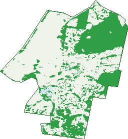
Green: 10 m cells where trees dominate, satellite 2021. Blue: water. The line is the suburb boundary.
| Canopy share, 1 m canopy height map, 2020 | 18.5% |
|---|---|
| Land with trees, 10 m satellite map, 2021 | 33.7% |
Demographics
Unemployment 1.8% · Labour-force participation 77.5%
Population by age in Jerrabomberra
| 0-4 | 591 |
|---|---|
| 5-14 | 1,498 |
| 15-19 | 765 |
| 20-24 | 563 |
| 25-34 | 935 |
| 35-44 | 1,378 |
| 45-54 | 1,743 |
| 55-64 | 1,244 |
| 65-74 | 590 |
| 75-84 | 235 |
| 85+ | 55 |
Dwelling types in Jerrabomberra
| House | 2,695 |
|---|---|
| Townhouse | 427 |
| Apartment | 0 |
| Other | 0 |
Households by weekly income in Jerrabomberra
| <$650 | 134 |
|---|---|
| $650-1,499 | 275 |
| $1,500-2,999 | 817 |
| $3,000+ | 1,707 |
Top ancestries in Jerrabomberra
| Australian | 3,801 |
|---|---|
| English | 3,462 |
| Irish | 1,197 |
| Scottish | 1,070 |
| Other | 987 |
| Italian | 537 |
Housing tenure in Jerrabomberra
| Owned | 942 |
|---|---|
| Mortgage | 1,551 |
| Rented | 591 |
| Other | 10 |
Cars per household in Jerrabomberra
| 0 | 19 |
|---|---|
| 1 | 636 |
| 2 | 1,424 |
| 3 | 617 |
| 4+ | 413 |
Commute to work in Jerrabomberra
| Car | 4,298 |
|---|---|
| Train | 0 |
| Bus | 19 |
| Tram/ferry | 0 |
| Walked | 30 |
| Bicycle | 18 |
| Home | 597 |
Top countries of birth in Jerrabomberra
| England | 284 |
|---|---|
| India | 129 |
| New Zealand | 127 |
| United States | 84 |
| South Africa | 75 |
| North Macedonia | 72 |
Languages used at home in Jerrabomberra
| Macedonian | 142 |
|---|---|
| Italian | 101 |
| Hindi | 61 |
| Mandarin | 60 |
| Serbian | 56 |
| Spanish | 48 |
Birds & Wildlife Nearby
52,787 bird observations recorded near Jerrabomberra — most often seen:
- Australian Magpie (4,192)
- Galah (3,601)
- Crimson Rosella (3,032)
- Magpie-lark (2,676)
- Red Wattlebird (2,491)
- Pied Currawong (2,420)
- Crested Pigeon (2,303)
- Sulphur-crested Cockatoo (2,212)
- Australian Raven (2,172)
- Superb Fairy-wren (1,977)
- Common Starling (1,975)
- Common Myna (1,855)
- House Sparrow (1,729)
Show all 30 birds recorded near Jerrabomberra
- Eurasian Blackbird (1,681)
- Australian Wood Duck (1,678)
- Yellow-rumped Thornbill (1,475)
- Pacific Black Duck (1,347)
- Silvereye (1,341)
- Eastern Rosella (1,229)
- Grey Fantail (1,216)
- Willie Wagtail (1,214)
- Yellow-faced Honeyeater (1,055)
- Noisy Miner (1,052)
- Eurasian Coot (1,043)
- Weebill (1,033)
- Welcome Swallow (997)
- Dusky Moorhen (984)
- Spotted Pardalote (950)
- Masked Lapwing (949)
- Little Pied Cormorant (908)
Sightings reported by observers, not a survey, so the counts show what people record rather than what lives here. Source: Atlas of Living Australia.
Nearby Suburbs
The closest suburbs to Jerrabomberra:
- Environa (1.9 km)
- Karabar (2.9 km)
- Queanbeyan West (3.1 km)
- Tralee (4 km)
- Queanbeyan (4.3 km)
- Greenleigh (4.5 km)
- Crestwood (4.5 km)
- Googong (5 km)
Embed this suburb
Add this free Jerrabomberra stat card to your own site — just copy the code:
Preview:
Cite this page
Quoting these figures? Copy the credit line:
Keep an eye on Jerrabomberra
One email when this data meaningfully changes — new census figures, prices, rankings. No spam, unsubscribe anytime.
Streets
- Acacia Drive (24)
- Adina Court (3)
- Albizia Place (9)
- Alder Close (29)
- Allambee Street (17)
- Applebox Place (7)
- Aspen Rise (24)
- Balcombe Street (41)
- Balladonia Place (5)
- Banyalla Close (7)
- Barrigan Place (12)
- Bayside Court (30)
- Beech Place (10)
- Bellbush Close (14)
- Benalla Court (14)
- Bicentennial Drive (191)
- Birch Way (11)
- Birubi Place (11)
- Blackwood Place (10)
- Bluebell Glen (5)
- Bluestone Gardens (48)
- Bocciarini Court (5)
- Boree Place (10)
- Bottlebrush Place (8)
- Breen Place (27)
- Brennan Court (6)
- Brudenell Drive (138)
- Burgan Grove (12)
- Byrne Place (6)
- Callitris Place (14)
- Camphorwood Close (6)
- Cane Place (9)
- Carolyn Jackson Drive (65)
- Coachwood Avenue (9)
- Colverwell Crescent (18)
- Constance Road (14)
- Coora Place (14)
- Copperfield Place (9)
- Coral Drive (44)
- Cotter Place (16)
- Cross Place (4)
- Darmody Place (20)
- De Smet Court (6)
- Dennis Place (18)
- Dillwynia Crescent (17)
- Dixon Place (15)
- Dora Street (36)
- Edwin Land Parkway (5)
- Elaroo Place (6)
- Ella Close (6)
- Elm Way (106)
- Elouera Court (16)
- Emerson Court (11)
- English Grove (10)
- Environa Drive (4)
- Esmond Avenue (32)
- Eucalypt Rise (24)
- Eucalyptus Rise (24)
- Euroka Place (15)
- Evan Place (7)
- Ferdinand Lane (5)
- Firethorn Place (25)
- Forest Drive (49)
- Frangipani Place (18)
- Franklin Court (20)
- Freestone Crescent (29)
- Gabriel Avenue (33)
- Glenora Court (6)
- Goolara Place (19)
- Grady Place (7)
- Guise Place (7)
- Gurrana Street (3)
- Halloran Drive (195)
- Hamilton Place (12)
- Hanna Place (4)
- Hickory Place (7)
- Homestead Gardens (12)
- Hoover Road (1)
- Hudson Place (15)
- Hunter Close (12)
- Ironbark Circuit (77)
- Jacaranda Drive (89)
- Jasmine Gardens (20)
- Jerrabomberra Hill Road (13)
- Jerrabomberra Parkway (18)
- Johanna Moore Avenue (16)
- Kalang Place (16)
- Kavanagh Street (15)
- Kennedy Avenue (16)
- Kinlyside Avenue (39)
- Kowa Place (8)
- Kowen Place (7)
- Lakeview Gardens (51)
- Lanyon Drive (7)
- Laurel Place (18)
- Laurence Close (8)
- Lawson Place (8)
- Lerra Street (13)
- Limestone Drive (19)
- Lobelia Close (14)
- Lomandra Place (4)
- Macadamia Close (38)
- Mackellar Place (4)
- Magnolia Close (24)
- Majura Place (20)
- Maple Crescent (32)
- Mariners Court (15)
- May Gibbs Place (10)
- Mcintyre Street (2)
- Melaleuca Place (18)
- Melrose Place (10)
- Miles Place (8)
- Minda Place (11)
- Morella Avenue (50)
- Morley Way (9)
- Murruba Place (30)
- Myrtle Close (20)
- Nicholii Loop (39)
- North Terrace (2)
- Nugent Close (19)
- Numeralia Drive (17)
- Nyora Place (9)
- O'hara Place (6)
- O'sullivan Road (21)
- Olive Place (7)
- Orchid Avenue (3)
- Ormond Court (10)
- Palm Court (16)
- Pannamena Crescent (50)
- Parkview Crescent (36)
- Pemberton Place (12)
- Pepper Place (11)
- Peppercorn Way (14)
- Poplar Crescent (31)
- Redwood Avenue (74)
- Robinia Place (18)
- Rosewood Glen (77)
- She-oak Place (8)
- Silky Oak Circle (9)
- Snow Gum Place (14)
- Southbar Road (3)
- Stella Place (4)
- Stringybark Drive (39)
- Stromlo Place (11)
- Sweetgum Place (6)
- Sycamore Street (23)
- Tamarind Place (5)
- Tarilta Court (7)
- Tasker Place (5)
- Tea Tree Close (10)
- Teak Place (6)
- Tennant Place (8)
- Terrara Close (18)
- Tompsitt Drive (3)
- Toolagal Place (11)
- Tooroonga Crescent (30)
- Torpy Place (37)
- Tully Place (14)
- Turner Place (8)
- Umina Place (17)
- Unwin Avenue (38)
- Uralba Court (4)
- Urangarra Place (14)
- Walker Crescent (84)
- Walter Close (7)
- Wanawong Court (10)
- Wark Place (9)
- Waterfall Drive (114)
- Waterview Gardens (12)
- Weeroona Place (8)
- Wentworth Court (12)
- Willow Close (6)
- Winter Place (21)
- Wisteria Close (4)
- Wolseley Place (8)
- Woodhill Link (55)
- Wyena Court (9)