Inverell NSW 2360
7,152 addresses · 242 streets
New England Electorate › Inverell LGA › Inverell · 455 km from Sydney
📦 Thinking of moving here? Read the Inverell moving guide

Living Here
Inverell is a suburb of New South Wales, home to about 12,057 people, with a median age of 41. The typical household earns around $1,187 a week, with median rent near $270 a week. Most homes are houses. About 65% of households own their home and 33% rent. Most workers drive to work. Common community backgrounds include Australian, English, Aboriginal. On the ABS socio-economic scale it sits in decile 2 of 10 nationally — a more disadvantaged area.
Over time — Census 2001 → 2021
Dashed line: district figures for the Inverell statistical area (SA2), the smallest area the ABS published before 2011. Solid line: Inverell itself.
Getting Around & Local Services
3 supermarkets
1 Catholic church
2 pharmacies
2 doctors & medical clinics
1 hospital
1 vet
1 library
1 post office
6 service stations
4 gyms & sports centres
1 golf club
2 butchers
2 hardware stores
1 electrician
1 plumber
Getting around. Airport: Inverell Airport, 12.8 km south.
Socio-economic Standing
Deciles from 1 (lowest) to 10 (highest), against all Australian suburbs. The overall figure weighs advantage and disadvantage together; economic resources counts income and housing, and education & jobs counts qualifications and occupation. They often differ. Source: ABS SEIFA 2021.
Tree cover
🌳 Tree canopy: 21.2% share of land under canopy · satellite map, 2020
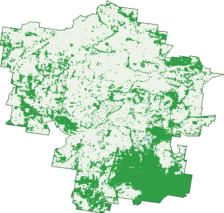
Green: 10 m cells where trees dominate, satellite 2021. Blue: water. The line is the suburb boundary.
| Canopy share, 1 m canopy height map, 2020 | 21.2% |
|---|---|
| Land with trees, 10 m satellite map, 2021 | 31.0% |
Demographics
Unemployment 6.3% · Labour-force participation 52.7%
Population by age in Inverell
| 0-4 | 709 |
|---|---|
| 5-14 | 1,649 |
| 15-19 | 733 |
| 20-24 | 674 |
| 25-34 | 1,443 |
| 35-44 | 1,285 |
| 45-54 | 1,343 |
| 55-64 | 1,435 |
| 65-74 | 1,405 |
| 75-84 | 1,012 |
| 85+ | 374 |
Dwelling types in Inverell
| House | 4,041 |
|---|---|
| Townhouse | 465 |
| Apartment | 57 |
| Other | 39 |
Households by weekly income in Inverell
| <$650 | 1,058 |
|---|---|
| $650-1,499 | 1,564 |
| $1,500-2,999 | 1,212 |
| $3,000+ | 453 |
Top ancestries in Inverell
| Australian | 5,233 |
|---|---|
| English | 4,788 |
| Aboriginal | 1,224 |
| Scottish | 1,129 |
| Irish | 1,113 |
| Ancestry NS | 1,050 |
Housing tenure in Inverell
| Owned | 1,636 |
|---|---|
| Mortgage | 1,295 |
| Rented | 1,499 |
| Other | 70 |
Cars per household in Inverell
| 0 | 344 |
|---|---|
| 1 | 1,711 |
| 2 | 1,586 |
| 3 | 557 |
| 4+ | 305 |
Commute to work in Inverell
| Car | 3,617 |
|---|---|
| Train | 0 |
| Bus | 8 |
| Tram/ferry | 0 |
| Walked | 170 |
| Bicycle | 10 |
| Home | 354 |
Top countries of birth in Inverell
| England | 127 |
|---|---|
| Philippines | 123 |
| Fiji | 87 |
| New Zealand | 80 |
| Brazil | 47 |
| India | 43 |
Languages used at home in Inverell
| Portuguese | 55 |
|---|---|
| Tagalog | 55 |
| Mandarin | 45 |
| Filipino | 44 |
| Vietnamese | 35 |
| Italian | 22 |
Birds & Wildlife Nearby
63,383 bird observations recorded near Inverell — most often seen:
- Australian Magpie (3,669)
- Galah (3,482)
- Crested Pigeon (3,372)
- Eastern Rosella (3,230)
- Rainbow Lorikeet (3,060)
- Magpie-lark (3,053)
- House Sparrow (2,857)
- Sulphur-crested Cockatoo (2,808)
- Willie Wagtail (2,604)
- Black-faced Cuckoo-shrike (2,589)
- Red Wattlebird (2,575)
- Rock Dove (2,435)
- Common Starling (2,335)
Show all 30 birds recorded near Inverell
- Common Myna (2,226)
- Blue-faced Honeyeater (2,111)
- Pied Currawong (2,002)
- Eurasian Blackbird (1,865)
- Pied Butcherbird (1,836)
- Superb Fairy-wren (1,762)
- Spotted Turtle-dove (1,721)
- Torresian Crow (1,649)
- Laughing Kookaburra (1,578)
- Brown Honeyeater (1,531)
- White-plumed Honeyeater (1,160)
- Welcome Swallow (1,141)
- Red-rumped Parrot (994)
- Spiny-cheeked Honeyeater (956)
- Little Corella (951)
- Pacific Black Duck (916)
- Australian King-parrot (915)
Sightings reported by observers, not a survey, so the counts show what people record rather than what lives here. Source: Atlas of Living Australia.
Nearby Suburbs
The closest suburbs to Inverell:
- Auburn Vale (7.6 km)
- Brodies Plains (8.6 km)
- Gilgai (10 km)
- Long Plain (11.8 km)
- Rob Roy (12.1 km)
- Wandera (12.5 km)
- Swanbrook (12.6 km)
- Gum Flat (14.6 km)
Embed this suburb
Add this free Inverell stat card to your own site — just copy the code:
Preview:
Cite this page
Quoting these figures? Copy the credit line:
Keep an eye on Inverell
One email when this data meaningfully changes — new census figures, prices, rankings. No spam, unsubscribe anytime.
Streets
- Addison Road (5)
- Albert Street (33)
- Allambie Crescent (8)
- Alsace Road (11)
- Anderson Street (15)
- Andrew Lane (1)
- Andrew Street (55)
- Angel Avenue (22)
- Angorra Close (7)
- Arrawatta Road (8)
- Arthur Street (13)
- Ashford Road (40)
- Auburn Vale Road (96)
- Avern Street (17)
- Bannockburn Road (53)
- Beaulieu Lane (5)
- Bennett Lane (4)
- Bennett Street (59)
- Bertha Street (11)
- Bimbadeen Drive (14)
- Blair Athol Road (2)
- Bolands Lane (10)
- Bonnie View Place (5)
- Borthwick Street (22)
- Box Tree Place (10)
- Brae Street (154)
- Brewery Street (78)
- Brissett Street (30)
- Brosnans Lane (27)
- Brown Street (30)
- Brownleigh Vale Drive (41)
- Browns Lane (7)
- Bullamungee Close (5)
- Bundanoon Lane (9)
- Bundarra Road (38)
- Burgess Street (2)
- Burtenshaw Road (7)
- Butler Street (58)
- Buxton Street (6)
- Byron Station Lane (2)
- Byron Street (218)
- Caloola Drive (15)
- Cameron Street (17)
- Campbell Street (33)
- Carlyle Street (5)
- Chester Street (105)
- Chisholm Street (39)
- Cicada Lane (4)
- Clancys Drive (15)
- Clinton Lane (6)
- Clive Street (68)
- Cloonan Terrace (6)
- Coggan Place (11)
- Colin Street (15)
- Coolibah Drive (28)
- Coopers Road (7)
- Copeton Dam Road (16)
- Corella Court (8)
- Crestview Place (30)
- Cunningham Place (18)
- Cunninghams Lane (7)
- Currawong Place (6)
- Daley Close (11)
- Davey Street (10)
- Defraines Lane (7)
- Delvyn Drive (13)
- Deodara Drive (25)
- Devon Street (2)
- Ditzells Drive (13)
- Dog Trap Lane (28)
- Doncaster Drive (17)
- East Street (17)
- Edward Street (9)
- Elm Place (6)
- Elsmore Road (5)
- Eucalypt Drive (10)
- Eugene Street (33)
- Evans Street (103)
- Fernhill Road (89)
- Fisher Road (6)
- Flinders Place (4)
- Flora Place (6)
- Froude Street (87)
- Fullers Lane (20)
- George Street (116)
- Gilchrist Street (35)
- Gillespies Lane (4)
- Girle Street (26)
- Glen Innes Road (94)
- Goonoowigall Road (11)
- Gordon Street (81)
- Granville Street (102)
- Greaves Street (83)
- Gum Flat Road (1)
- Gwydir Highway (56)
- Hampton Court (13)
- Harland Street (18)
- Hatcher Street (6)
- Henderson Street (122)
- Herbert Street (58)
- High Lane (1)
- High St Lane (6)
- High Street (61)
- Hindmarsh Street (28)
- Hopper Street (16)
- Howard Street (25)
- Jacaranda Crescent (15)
- Jack Street (32)
- Jardine Road (3)
- John Street (3)
- Karinda Drive (7)
- Kerri Road (3)
- Killean Street (73)
- King Lane (1)
- King Street (118)
- Kingfisher Drive (53)
- Kings Plains Road (8)
- Knapton Street (1)
- Kookaburra Lane (20)
- Kuna Avenue (6)
- Kurrajong Place (4)
- Lake Inverell Drive (22)
- Lang Street (53)
- Lauder Street (36)
- Lawrence Street (66)
- Leonard Street (22)
- Leviathan Road (4)
- Lewin Street (63)
- Libani Close (23)
- Lindsay Avenue (28)
- Lochinvar Lane (3)
- Lorikeet Lane (1)
- Loxton Road (9)
- Macintyre Street (105)
- Mackie Lane (14)
- Mansfield Street (55)
- Masons Lane (10)
- Mather Street (81)
- Mawson Street (16)
- Max Place (14)
- May Street (34)
- Mcbrides Lane (7)
- Mcfertridge Lane (2)
- Mcilveen Park Road (4)
- Mcilveen Street (10)
- Mcivor Street (20)
- Mclean Road (6)
- Mcneils Road (7)
- Medhurst Road (3)
- Medora Street (39)
- Miles Street (35)
- Mitchell Crescent (10)
- Moore Street (91)
- Moseley-dene Lane (1)
- Mulligan Street (83)
- Nullamanna Road (7)
- O'connor Street (20)
- Oak Place (14)
- Oakland Lane (16)
- Old Bundarra Road (208)
- Oliver Street (80)
- Onus Avenue (9)
- Orchard Place (18)
- Osterley Terrace (9)
- Oswald Street (88)
- Oswald Terrace (4)
- Otho Lane (6)
- Otho Street (184)
- Oxley Place (24)
- Palaroo Lane (7)
- Parkland Close (6)
- Pearson Road (4)
- Plieffer Place (18)
- Prince Street (67)
- Prince Terrace (8)
- Queen Street (19)
- Queens Terrace (46)
- Raglan Street (32)
- Railway Close (3)
- Rifle Range Road (36)
- Ring Street (61)
- Rivendell Road (4)
- Rivers Street (38)
- Roscrae Lane (16)
- Rose Street (46)
- Rosella Place (7)
- Roseneath Lane (2)
- Rosie Lane (1)
- Rosies Lane (1)
- Ross Street (114)
- Rosslyn Street (30)
- Runnymede Drive (22)
- Sapphire Street (50)
- Sayers Lane (4)
- Sequoia Place (9)
- Shirley Street (50)
- Short Street (113)
- Sierra Drive (10)
- Staggs Lane (30)
- Stainfield Drive (24)
- Stirling Street (23)
- Sunnyside Place (20)
- Swan Street (37)
- Swanbrook Road (77)
- Sweaney Street (28)
- Sylvan Drive (20)
- Talbragar Close (16)
- Tamboura Close (4)
- Taylor Avenue (5)
- Terry Drive (38)
- The Gully Road (4)
- Tingha Road (10)
- Toms Drive (15)
- Tulare Crescent (13)
- Tullochard East Lane (7)
- Tullochard West Road (4)
- Urabatta Lane (4)
- Urabatta Street (109)
- Vernon Street (54)
- Victoria Street (16)
- Vincent Place (11)
- Vintage Close (17)
- Vivian Street (62)
- Wade Street (17)
- Warana Drive (13)
- Waratah Avenue (47)
- Warialda Road (149)
- Wattle Hill Road (3)
- Wattle Place (7)
- Wesley Street (9)
- White Box Place (8)
- Whittingham Street (17)
- William Street (19)
- Willow Place (5)
- Windoona Drive (1)
- Wolbah Close (17)
- Wood Street (36)
- Woodland Avenue (20)
- Wyndham Street (8)
- Wynne Street (33)
- Yetman Road (57)
- Zircon Street (22)