Hurstville NSW 2220
20,151 addresses · 119 streets
Barton Electorate › Georges River LGA › Hurstville · 15 km from Sydney
📦 Thinking of moving here? Read the Hurstville moving guide

Living Here
A southern-Sydney hub with a high-rise centre, Hurstville is a busy, transport-connected suburb. Households average 2.8 people and the median age is 33. Median household income is $1,804 a week, with rent about $470.
Hurstville is a suburb of New South Wales, home to about 31,162 people, with a median age of 33. The typical household earns around $1,804 a week, with median rent near $470 a week. Most homes are apartments. About 50% of households own their home and 48% rent. Most workers work from home. Common community backgrounds include Chinese, English, Ancestry NS. On the ABS socio-economic scale it sits in decile 7 of 10 nationally — a mid-range area.
Over time — Census 2001 → 2021
Dashed line: district figures for the Hurstville statistical area (SA2), the smallest area the ABS published before 2011. Solid line: Hurstville itself.
Getting Around & Local Services
1 playground
4 hardware stores
Getting around. Train station: Hurstville, 300 m south · Metro station: Belmore, 5.4 km north · Bus interchange: Bankstown Station, 8.1 km north-west · Airport: Sydney (Kingsford Smith) Airport, 7.5 km east.
Socio-economic Standing
Deciles from 1 (lowest) to 10 (highest), against all Australian suburbs. The overall figure weighs advantage and disadvantage together; economic resources counts income and housing, and education & jobs counts qualifications and occupation. They often differ. Source: ABS SEIFA 2021.
Tree cover
🌳 Tree canopy: 9.8% share of land under canopy · satellite map, 2020
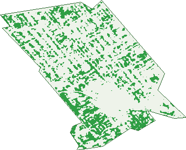
Green: 10 m cells where trees dominate, satellite 2021. Blue: water. The line is the suburb boundary.
| Canopy share, 1 m canopy height map, 2020 | 9.8% |
|---|---|
| Surveyed canopy, Greater Sydney aerial survey, 2019 | 12.9% |
| Land with trees, 10 m satellite map, 2021 | 19.8% |
Demographics
Unemployment 6.9% · Labour-force participation 57.4%
Population by age in Hurstville
| 0-4 | 1,410 |
|---|---|
| 5-14 | 2,646 |
| 15-19 | 1,256 |
| 20-24 | 3,606 |
| 25-34 | 7,373 |
| 35-44 | 4,130 |
| 45-54 | 3,125 |
| 55-64 | 3,317 |
| 65-74 | 2,410 |
| 75-84 | 1,274 |
| 85+ | 618 |
Dwelling types in Hurstville
| House | 3,164 |
|---|---|
| Townhouse | 860 |
| Apartment | 6,467 |
| Other | 13 |
Households by weekly income in Hurstville
| <$650 | 1,604 |
|---|---|
| $650-1,499 | 2,620 |
| $1,500-2,999 | 3,445 |
| $3,000+ | 2,228 |
Top ancestries in Hurstville
| Chinese | 14,691 |
|---|---|
| Other | 7,769 |
| English | 2,300 |
| Ancestry NS | 1,772 |
| Australian | 1,771 |
| Greek | 914 |
Housing tenure in Hurstville
| Owned | 2,499 |
|---|---|
| Mortgage | 2,679 |
| Rented | 4,993 |
| Other | 188 |
Cars per household in Hurstville
| 0 | 2,216 |
|---|---|
| 1 | 4,879 |
| 2 | 2,286 |
| 3 | 648 |
| 4+ | 262 |
Commute to work in Hurstville
| Car | 4,079 |
|---|---|
| Train | 1,924 |
| Bus | 216 |
| Tram/ferry | 4 |
| Walked | 594 |
| Bicycle | 21 |
| Home | 4,090 |
Top countries of birth in Hurstville
| China | 8,925 |
|---|---|
| Nepal | 4,938 |
| Hong Kong | 1,128 |
| Indonesia | 548 |
| Philippines | 536 |
| Malaysia | 448 |
Languages used at home in Hurstville
| Mandarin | 8,123 |
|---|---|
| Cantonese | 5,040 |
| Nepali | 4,793 |
| Arabic | 802 |
| Greek | 651 |
| Indonesian | 507 |
Birds & Wildlife Nearby
161,959 bird observations recorded near Hurstville — most often seen:
- Rainbow Lorikeet (14,606)
- Noisy Miner (11,978)
- Australian Raven (8,920)
- Sulphur-crested Cockatoo (8,867)
- Australian White Ibis (8,595)
- Pied Currawong (8,562)
- Australian Magpie (7,530)
- Welcome Swallow (5,880)
- Common Myna (5,813)
- Rock Dove (5,702)
- Laughing Kookaburra (5,216)
- Magpie-lark (4,940)
- Grey Butcherbird (4,851)
Show all 30 birds recorded near Hurstville
- Dusky Moorhen (4,623)
- Chestnut Teal (4,534)
- Pacific Black Duck (4,379)
- Spotted Turtle-dove (4,371)
- Superb Fairy-wren (4,304)
- Silvereye (4,280)
- Red-whiskered Bulbul (3,992)
- Crested Pigeon (3,535)
- Red Wattlebird (3,490)
- White-faced Heron (3,286)
- Willie Wagtail (3,275)
- Silver Gull (3,129)
- New Holland Honeyeater (2,855)
- Little Black Cormorant (2,792)
- Common Starling (2,664)
- Little Pied Cormorant (2,575)
- Eastern Pied Currawong (2,415)
Sightings reported by observers, not a survey, so the counts show what people record rather than what lives here. Source: Atlas of Living Australia.
Nearby Suburbs
The closest suburbs to Hurstville:
- South Hurstville (1.4 km)
- Allawah (1.4 km)
- Penshurst (1.6 km)
- Hurstville Grove (1.7 km)
- Carlton (1.9 km)
- Bexley (2.2 km)
- Connells Point (2.5 km)
- Mortdale (2.5 km)
Embed this suburb
Add this free Hurstville stat card to your own site — just copy the code:
Preview:
Cite this page
Quoting these figures? Copy the credit line:
Keep an eye on Hurstville
One email when this data meaningfully changes — new census figures, prices, rankings. No spam, unsubscribe anytime.
Streets
- Albert Street (13)
- Alfred Street (42)
- Alma Street (46)
- Annie Street (43)
- Australia Street (32)
- Barnards Avenue (67)
- Barratt Street (45)
- Bassett Street (298)
- Beatrice Street (16)
- Bellevue Parade (230)
- Beronga Avenue (25)
- Bond Street (151)
- Botany Street (1)
- Bridge Street (70)
- Bristol Road (102)
- Butler Lane (1)
- Butler Road (47)
- Carrington Avenue (548)
- Carysfort Street (24)
- Clevedon Road (76)
- Cole Lane (2)
- Cole Street (26)
- Cook Road (2)
- Crofts Avenue (494)
- Cronulla Street (11)
- Croot Street (41)
- Crosby Avenue (19)
- Cross Street (339)
- Croydon Road (98)
- Dalcassia Street (137)
- Days Avenue (5)
- Denman Street (53)
- Diment Way (14)
- Donald Street (146)
- Dora Street (764)
- Dudley Street (15)
- Durham Street (126)
- Edith Street (44)
- Elizabeth Street (10)
- Emily Street (75)
- Empress Street (312)
- Finney Street (31)
- Forest Road (3,224)
- Gallipoli Street (34)
- Gannons Avenue (27)
- Gloucester Road (616)
- Gordon Street (61)
- Greenbank Street (534)
- Heber Street (20)
- Hill Street (119)
- Hillcrest Avenue (117)
- Hodge Street (103)
- Hudson Street (480)
- Humphreys Lane (10)
- Hurstville Road (22)
- Jack Brabham Drive (839)
- Joan Street (16)
- John Street (18)
- Kenwyn Street (2)
- Kimberley Road (97)
- King Georges Road (63)
- Lily Lane (1)
- Lily Street (87)
- Louis Lane (1)
- Louis Terrace (44)
- Lovell Street (1)
- Low Street (79)
- Lyle Avenue (45)
- Mabel Street (38)
- Macmahon Street (314)
- Macpherson Street (76)
- Maher Street (70)
- Mcleod Street (35)
- Meakem Street (22)
- Millett Street (330)
- Moore Street (74)
- Moyarta Street (15)
- Neirbo Avenue (44)
- Noeline Street (13)
- O'briens Road (37)
- Orange Lane (3)
- Orange Street (66)
- Ormonde Parade (189)
- Park Road (632)
- Patrick Street (244)
- Pearl Street (376)
- Queens Road (550)
- Railway Parade (631)
- Regan Street (7)
- Roberts Lane (4)
- Romani Avenue (68)
- Rose Street (31)
- Rosebank Crescent (43)
- Ruby Street (25)
- Sackville Street (12)
- Salisbury Street (6)
- Smiths Avenue (91)
- Somerset Street (36)
- St Georges Parade (319)
- Stoney Creek Road (1)
- Super Centre (75)
- Taronga Street (56)
- Taunton Road (60)
- The Avenue (641)
- Thomas Street (64)
- Thomond Street (10)
- Timothy Street (13)
- Treacy Street (697)
- Truman Street (4)
- Vine Street (99)
- Warraba Street (54)
- Warwick Street (56)
- Wellington Road (52)
- West Street (464)
- Weston Road (53)
- Woids Avenue (188)
- Woniora Road (928)
- Woodville Street (313)
- Wright Street (621)