Guildford NSW 2161
10,387 addresses · 138 streets
McMahon Electorate › Cumberland LGA › Guildford · 20 km from Sydney
📦 Thinking of moving here? Read the Guildford moving guide

Living Here
A diverse, family-dense suburb in Sydney's west, Guildford has large households averaging 3.1 people and a young median age of 31. Median household income is $1,314 a week, with rent around $378.
Guildford is a suburb of New South Wales, home to about 24,091 people, with a median age of 31. The typical household earns around $1,314 a week, with median rent near $378 a week. Most homes are houses. About 50% of households own their home and 48% rent. Most workers drive to work. Common community backgrounds include Lebanese, Australian, Ancestry NS. On the ABS socio-economic scale it sits in decile 2 of 10 nationally — a more disadvantaged area.
Over time — Census 2001 → 2021
Dashed line: district figures for the Guildford - South Granville statistical area (SA2), the smallest area the ABS published before 2011. Solid line: Guildford itself.
Getting Around & Local Services
3 physiotherapists
1 beauty salon
1 plumber
1 carpenter
Getting around. Train station: Guildford, 450 m west · Light rail stop: Parramatta Square, 4.6 km north · Bus interchange: Parramatta EA, 5.9 km north-east · Ferry wharf: Parramatta Ferry Wharf, 4.9 km north-east · Airport: Bankstown Airport, 7.8 km south.
Socio-economic Standing
Deciles from 1 (lowest) to 10 (highest), against all Australian suburbs. The overall figure weighs advantage and disadvantage together; economic resources counts income and housing, and education & jobs counts qualifications and occupation. They often differ. Source: ABS SEIFA 2021.
Tree cover
🌳 Tree canopy: 9.9% share of land under canopy · satellite map, 2020
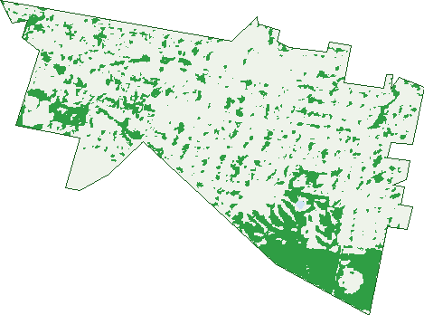
Green: 10 m cells where trees dominate, satellite 2021. Blue: water. The line is the suburb boundary.
| Canopy share, 1 m canopy height map, 2020 | 9.9% |
|---|---|
| Surveyed canopy, Greater Sydney aerial survey, 2019 | 11.5% |
| Land with trees, 10 m satellite map, 2021 | 18.4% |
Demographics
Unemployment 10.6% · Labour-force participation 40.5%
Population by age in Guildford
| 0-4 | 2,067 |
|---|---|
| 5-14 | 3,460 |
| 15-19 | 1,658 |
| 20-24 | 1,820 |
| 25-34 | 4,284 |
| 35-44 | 3,273 |
| 45-54 | 2,507 |
| 55-64 | 2,333 |
| 65-74 | 1,566 |
| 75-84 | 818 |
| 85+ | 318 |
Dwelling types in Guildford
| House | 3,841 |
|---|---|
| Townhouse | 1,102 |
| Apartment | 2,035 |
| Other | 6 |
Households by weekly income in Guildford
| <$650 | 1,529 |
|---|---|
| $650-1,499 | 2,123 |
| $1,500-2,999 | 1,929 |
| $3,000+ | 918 |
Top ancestries in Guildford
| Other | 8,490 |
|---|---|
| Lebanese | 5,839 |
| Australian | 3,085 |
| Ancestry NS | 2,784 |
| English | 2,228 |
| Chinese | 1,592 |
Housing tenure in Guildford
| Owned | 1,470 |
|---|---|
| Mortgage | 1,949 |
| Rented | 3,311 |
| Other | 121 |
Cars per household in Guildford
| 0 | 968 |
|---|---|
| 1 | 2,684 |
| 2 | 1,951 |
| 3 | 739 |
| 4+ | 480 |
Commute to work in Guildford
| Car | 3,160 |
|---|---|
| Train | 282 |
| Bus | 37 |
| Tram/ferry | 0 |
| Walked | 59 |
| Bicycle | 5 |
| Home | 1,677 |
Top countries of birth in Guildford
| Lebanon | 2,487 |
|---|---|
| Afghanistan | 1,099 |
| China | 766 |
| Pakistan | 641 |
| Iraq | 541 |
| Vietnam | 453 |
Languages used at home in Guildford
| Arabic | 7,278 |
|---|---|
| Mandarin | 774 |
| Urdu | 631 |
| Turkish | 562 |
| Cantonese | 497 |
| Vietnamese | 427 |
Birds & Wildlife Nearby
26,640 bird observations recorded near Guildford — most often seen:
- Rainbow Lorikeet (2,959)
- Australian White Ibis (2,747)
- Australian Magpie (1,845)
- Noisy Miner (1,807)
- Rock Dove (1,516)
- Common Myna (1,378)
- Australian Raven (1,225)
- Sulphur-crested Cockatoo (945)
- Magpie-lark (937)
- Dusky Moorhen (877)
- Australian Wood Duck (839)
- Crested Pigeon (821)
- Pied Currawong (722)
Show all 30 birds recorded near Guildford
- Pacific Black Duck (688)
- Galah (652)
- Welcome Swallow (591)
- Spotted Turtle-dove (588)
- Birds (554)
- Laughing Kookaburra (526)
- Masked Lapwing (491)
- Willie Wagtail (485)
- Superb Fairy-wren (479)
- Little Corella (441)
- Grey Butcherbird (407)
- Red Wattlebird (407)
- Common Starling (391)
- Eurasian Coot (386)
- Australasian Purple Swamphen (339)
- Red-whiskered Bulbul (301)
- Southern Noisy Miner (296)
Sightings reported by observers, not a survey, so the counts show what people record rather than what lives here. Source: Atlas of Living Australia.
Nearby Suburbs
The closest suburbs to Guildford:
- Old Guildford (1.1 km)
- South Granville (2 km)
- Yennora (2.1 km)
- Merrylands (2.1 km)
- Guildford West (2.3 km)
- Holroyd (2.6 km)
- Merrylands West (2.7 km)
- Fairfield East (2.8 km)
Embed this suburb
Add this free Guildford stat card to your own site — just copy the code:
Preview:
Cite this page
Quoting these figures? Copy the credit line:
Keep an eye on Guildford
One email when this data meaningfully changes — new census figures, prices, rankings. No spam, unsubscribe anytime.
Streets
- Acland Street (30)
- Adah Street (50)
- Adam Street (109)
- Albert Street (95)
- Allison Road (71)
- Amherst Street (6)
- Apia Street (13)
- Apsley Street (4)
- Ashby Street (30)
- Autumn Place (14)
- Bangor Street (151)
- Barbers Road (1)
- Barrett Street (15)
- Beaufort Street (3)
- Berwick Street (141)
- Bird Avenue (16)
- Blaxcell Street (42)
- Bligh Street (55)
- Bolton Street (103)
- Bowden Street (53)
- Brazier Street (37)
- Bright Street (116)
- Brooks Street (13)
- Bursill Street (147)
- Bury Road (26)
- Byron Road (86)
- Calliope Street (238)
- Campbell Hill Road (107)
- Cann Street (32)
- Cardigan Street (196)
- Caroline Street (26)
- Carrington Road (32)
- Cecil Street (56)
- Chamberlain Road (129)
- Chetwynd Road (132)
- Chiltern Road (50)
- Churchill Street (33)
- Clarke Street (23)
- Clement Street (69)
- Cleone Street (116)
- Clyde Street (194)
- Constance Street (129)
- Craigelea Street (20)
- Craiglea Street (14)
- Cross Street (300)
- Davidson Road (36)
- Dennistoun Avenue (9)
- Donnelly Street (28)
- Dudley Road (57)
- Dunshea Place (19)
- Edgar Buggy Street (9)
- Elayne Place (9)
- Elizabeth Street (19)
- Essex Street (21)
- Eve Street (115)
- Excelsior Street (236)
- Fairview Street (30)
- Fowler Road (99)
- Frank Street (31)
- Garnet Street (64)
- George Street (22)
- Grassmere Street (36)
- Grove Street (48)
- Guernsey Street (26)
- Guildford Road (924)
- Harold Street (44)
- Harris Street (95)
- Hawksview Street (109)
- Henry Street (80)
- Highfield Road (14)
- Highland Street (30)
- Hinchen Street (57)
- Kane Street (59)
- Kenelda Avenue (41)
- Kennedy Street (52)
- Kirk Avenue (34)
- Linthorne Street (42)
- Lough Avenue (87)
- Lough Lane (1)
- Lucas Street (30)
- Maley Street (15)
- Margareta Close (10)
- Marian Street (58)
- Markey Street (73)
- Mcarthur Street (72)
- Mera Street (39)
- Military Road (220)
- Millie Street (17)
- Milner Road (96)
- Mountford Avenue (258)
- Murdock Lane (3)
- Murdock Street (29)
- Nadia Place (10)
- North Parade (9)
- O'connor Street (33)
- O'neill Street (215)
- Olsen Street (15)
- Osgood Street (47)
- Oswald Street (16)
- Oxford Street (48)
- Parker Street (1)
- Phyllis Crescent (19)
- Railway Terrace (347)
- Raleigh Street (14)
- Randolph Street (32)
- Rawson Road (197)
- Rhodes Avenue (62)
- Rickard Street (34)
- Robertson Street (141)
- Ronald Place (15)
- Rosebery Road (124)
- Rowley Road (95)
- Ruby Street (20)
- Salisbury Road (106)
- San Remo Place (34)
- Sheahan Avenue (59)
- Station Street (138)
- Stimson Street (91)
- Strickland Road (55)
- Surrey Street (8)
- Swift Street (34)
- Talbot Road (84)
- Tamplin Road (27)
- The Esplanade (182)
- Townsend Street (1)
- Trenton Road (25)
- Vulcan Street (19)
- Wainwright Street (24)
- West Street (42)
- Willis Avenue (4)
- Willoughby Street (51)
- Wills Place (8)
- Wingello Street (39)
- Wolseley Street (17)
- Woodstock Street (88)
- Woodville Road (792)
- Wynyard Street (101)
- Zillah Street (38)