Green Point NSW 2251
3,584 addresses · 126 streets
Robertson Electorate › Central Coast LGA › Green Point · 49 km from Sydney
📦 Thinking of moving here? Read the Green Point moving guide

Living Here
Green Point is a suburb of New South Wales, home to about 6,810 people, with a median age of 48. The typical household earns around $1,510 a week, with median rent near $425 a week. Most homes are houses. About 79% of households own their home and 20% rent. Most workers drive to work. Common community backgrounds include English, Australian, Irish. On the ABS socio-economic scale it sits in decile 7 of 10 nationally — a mid-range area.
Over time — Census 2001 → 2021
Dashed line: district figures for the Erina - Green Point statistical area (SA2), the smallest area the ABS published before 2011. Solid line: Green Point itself.
Getting Around & Local Services
3 Catholic churches
1 pharmacy
3 doctors & medical clinics
2 childcare & kindergartens
7 service stations
3 gyms & sports centres
2 dog parks
1 bakery
2 hairdressers
1 electrician
Getting around. Train station: Gosford, 4 km north-west · Ferry wharf: Davistown Central (RSL) Wharf, 4.4 km south · Airport: Somersby Airfield, 11.3 km north-west.
Socio-economic Standing
Deciles from 1 (lowest) to 10 (highest), against all Australian suburbs. The overall figure weighs advantage and disadvantage together; economic resources counts income and housing, and education & jobs counts qualifications and occupation. They often differ. Source: ABS SEIFA 2021.
Tree cover
🌳 Tree canopy: 70.4% share of land under canopy · satellite map, 2020
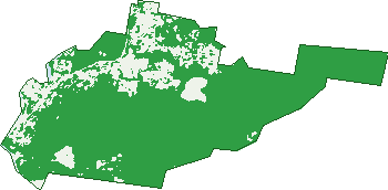
Green: 10 m cells where trees dominate, satellite 2021. Blue: water. The line is the suburb boundary.
| Canopy share, 1 m canopy height map, 2020 | 70.4% |
|---|---|
| Land with trees, 10 m satellite map, 2021 | 82.8% |
Demographics
Unemployment 3.6% · Labour-force participation 53.4%
Population by age in Green Point
| 0-4 | 337 |
|---|---|
| 5-14 | 776 |
| 15-19 | 397 |
| 20-24 | 322 |
| 25-34 | 526 |
| 35-44 | 746 |
| 45-54 | 856 |
| 55-64 | 954 |
| 65-74 | 979 |
| 75-84 | 662 |
| 85+ | 257 |
Dwelling types in Green Point
| House | 2,257 |
|---|---|
| Townhouse | 178 |
| Apartment | 189 |
| Other | 6 |
Households by weekly income in Green Point
| <$650 | 497 |
|---|---|
| $650-1,499 | 725 |
| $1,500-2,999 | 645 |
| $3,000+ | 594 |
Top ancestries in Green Point
| English | 3,005 |
|---|---|
| Australian | 2,544 |
| Irish | 906 |
| Scottish | 728 |
| Other | 568 |
| German | 243 |
Housing tenure in Green Point
| Owned | 1,167 |
|---|---|
| Mortgage | 889 |
| Rented | 517 |
| Other | 29 |
Cars per household in Green Point
| 0 | 168 |
|---|---|
| 1 | 1,024 |
| 2 | 951 |
| 3 | 329 |
| 4+ | 142 |
Commute to work in Green Point
| Car | 1,453 |
|---|---|
| Train | 15 |
| Bus | 11 |
| Tram/ferry | 0 |
| Walked | 14 |
| Bicycle | 6 |
| Home | 924 |
Top countries of birth in Green Point
| England | 447 |
|---|---|
| New Zealand | 111 |
| South Africa | 89 |
| Scotland | 53 |
| China | 44 |
| Germany | 39 |
Languages used at home in Green Point
| Spanish | 54 |
|---|---|
| Mandarin | 48 |
| Korean | 29 |
| Cantonese | 28 |
| Arabic | 27 |
| French | 26 |
Birds & Wildlife Nearby
28,052 bird observations recorded near Green Point — most often seen:
- Rainbow Lorikeet (2,757)
- Laughing Kookaburra (1,444)
- Australian Magpie (1,374)
- Noisy Miner (1,334)
- Australian Brush-turkey (1,114)
- Masked Lapwing (1,094)
- Sulphur-crested Cockatoo (1,094)
- White-faced Heron (1,053)
- Australian Pelican (996)
- Silvereye (996)
- Little Pied Cormorant (954)
- Tawny Frogmouth (894)
- Australian White Ibis (893)
Show all 30 birds recorded near Green Point
- Birds (879)
- Eastern Rainbow Lorikeet (861)
- Pacific Black Duck (837)
- Lewin's Honeyeater (825)
- Australian Wood Duck (790)
- Common Mallard (779)
- Southern Masked Lapwing (759)
- Bush Stone-curlew (697)
- Coastal New South Wales Australian Magpie (695)
- Bell Miner (689)
- Welcome Swallow (652)
- Southern Noisy Miner (635)
- Magpie-lark (633)
- Giinbaywarraymal (629)
- Grey Butcherbird (608)
- Little Wattlebird (546)
- Common Myna (541)
Sightings reported by observers, not a survey, so the counts show what people record rather than what lives here. Source: Atlas of Living Australia.
Nearby Suburbs
The closest suburbs to Green Point:
- Springfield (2.1 km)
- Erina (2.2 km)
- East Gosford (2.2 km)
- Yattalunga (2.4 km)
- Point Frederick (2.9 km)
- Kincumber (3.2 km)
- Saratoga (3.5 km)
- Kincumber South (3.7 km)
Embed this suburb
Add this free Green Point stat card to your own site — just copy the code:
Preview:
Cite this page
Quoting these figures? Copy the credit line:
Keep an eye on Green Point
One email when this data meaningfully changes — new census figures, prices, rankings. No spam, unsubscribe anytime.
Streets
- Alecia Close (14)
- Allandale Road (63)
- Amaroo Close (5)
- Aroona Road (9)
- Asca Drive (74)
- Avoca Drive (378)
- Bayside Drive (36)
- Beatties Road (10)
- Bellbower Close (22)
- Bellbrook Close (12)
- Bellwood Court (4)
- Bembooka Road (25)
- Berry Avenue (29)
- Beveridge Drive (37)
- Blue Wren Close (15)
- Blueberry Ash Road (10)
- Caldwell Close (22)
- Caljarni Close (9)
- Callistemon Avenue (20)
- Childs Close (19)
- Christle Street (49)
- Cooper Road (12)
- Corrella Avenue (4)
- Costa Close (7)
- Cudgee Close (12)
- Curtis Close (8)
- Dalgety Crescent (68)
- David Street (45)
- Davistown Road (6)
- Dundee Close (6)
- Eden Grove (1)
- Edgewater Avenue (34)
- Elfin Hill Road (10)
- Ernest Street (48)
- Eucalyptus Place (10)
- Fay Close (2)
- Fifth Avenue (10)
- First Avenue (45)
- Fourth Avenue (5)
- Fox Glove Close (8)
- Frangipani Avenue (44)
- Greenlee Street (30)
- Greenslope Drive (16)
- Greenvale Road (83)
- Grey Myrtle Road (14)
- Guss Cannon Close (19)
- Harmony Close (12)
- Henzel Road (67)
- Highland Road (43)
- Howard Avenue (35)
- Inverness Close (8)
- Irwin Place (17)
- Island View Drive (3)
- Jadash Close (7)
- James Sea Drive (151)
- Jeanette Close (8)
- Judy Anne Close (20)
- Julianne Street (4)
- June Close (7)
- Kanangra Street (6)
- Katherine Crescent (37)
- Kelly Close (4)
- Kenmare Road (18)
- Kincumber Street (1)
- Kolonga Close (9)
- Koolang Road (216)
- Lakewood Avenue (24)
- Lamont Close (11)
- Lanewood Court (4)
- Lauren Close (23)
- Legge Place (23)
- Leonie Parade (13)
- Letitia Close (14)
- Leura Avenue (1)
- Lexington Parade (25)
- Link Road (9)
- Marilyn Parade (26)
- Maxwell Close (14)
- Melissa Street (8)
- Merideth Place (29)
- Merindah Avenue (16)
- Michele Close (16)
- Milpera Road (228)
- Moir Place (8)
- Mount Place (12)
- Newman Close (7)
- Omaru Close (6)
- Orana Street (64)
- Pamela Close (15)
- Panorama Terrace (64)
- Park Crescent (8)
- Peckham Place (19)
- Pindari Terrace (19)
- Pixie Avenue (12)
- Quattroville Place (20)
- Redgrove Street (21)
- Rembrae Drive (54)
- River Oak Road (14)
- Roslyn Gardens (6)
- Ruby Place (12)
- Sandpiper Place (47)
- Sawyer Close (7)
- Second Avenue (65)
- Seventh Avenue (17)
- Silky Oak Close (15)
- Sixth Avenue (17)
- St Andrews Close (10)
- Stephen Close (11)
- Sun Valley Road (73)
- Sunshine Wattle Road (13)
- Teal Close (20)
- The Entrance Road (86)
- Third Avenue (17)
- Thistle Glen Close (12)
- Tranquil Close (13)
- Treeland Road (36)
- Verden Close (16)
- Victor Close (16)
- Wagtail Place (19)
- White Cedar Close (36)
- White Mahogany Road (14)
- Willowglen Close (13)
- Willowin Close (29)
- Woodport Close (28)
- Woorara Parade (18)
- Yvonne Close (9)