Granville NSW 2142
8,662 addresses · 109 streets
Parramatta Electorate › Cumberland LGA › Granville · 19 km from Sydney
📦 Thinking of moving here? Read the Granville moving guide

Living Here
A diverse, historic suburb beside Parramatta in Sydney's west, Granville is densifying around its rail station. Households average 2.8 people and the median age is 31. Median household income is $1,598 a week, with rent around $400.
Granville is a suburb of New South Wales, home to about 16,716 people, with a median age of 31. The typical household earns around $1,598 a week, with median rent near $400 a week. Most homes are apartments. About 43% of households own their home and 56% rent. Most workers drive to work. Common community backgrounds include Chinese, Lebanese, Ancestry NS. On the ABS socio-economic scale it sits in decile 3 of 10 nationally — a more disadvantaged area.
Over time — Census 2001 → 2021
Dashed line: district figures for the Granville - Clyde statistical area (SA2), the smallest area the ABS published before 2011. Solid line: Granville itself.
Getting Around & Local Services
34 doctors & medical clinics
3 physiotherapists
19 libraries
1 plumber
1 carpenter
Getting around. Train station: Granville, 400 m east · Light rail stop: Robin Thomas, 1.9 km north · Bus interchange: Parramatta EA, 3 km north-east · Ferry wharf: Parramatta Ferry Wharf, 2.2 km north · Airport: Bankstown Airport, 10.2 km south.
Socio-economic Standing
Deciles from 1 (lowest) to 10 (highest), against all Australian suburbs. The overall figure weighs advantage and disadvantage together; economic resources counts income and housing, and education & jobs counts qualifications and occupation. They often differ. Source: ABS SEIFA 2021.
Tree cover
🌳 Tree canopy: 8.8% share of land under canopy · satellite map, 2020
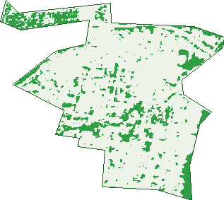
Green: 10 m cells where trees dominate, satellite 2021. Blue: water. The line is the suburb boundary.
| Canopy share, 1 m canopy height map, 2020 | 8.8% |
|---|---|
| Surveyed canopy, Greater Sydney aerial survey, 2019 | 11.4% |
| Land with trees, 10 m satellite map, 2021 | 13.3% |
Demographics
Unemployment 9.2% · Labour-force participation 53.5%
Population by age in Granville
| 0-4 | 997 |
|---|---|
| 5-14 | 1,606 |
| 15-19 | 704 |
| 20-24 | 2,012 |
| 25-34 | 4,234 |
| 35-44 | 2,416 |
| 45-54 | 1,698 |
| 55-64 | 1,434 |
| 65-74 | 1,009 |
| 75-84 | 451 |
| 85+ | 155 |
Dwelling types in Granville
| House | 1,898 |
|---|---|
| Townhouse | 500 |
| Apartment | 3,022 |
| Other | 10 |
Households by weekly income in Granville
| <$650 | 896 |
|---|---|
| $650-1,499 | 1,512 |
| $1,500-2,999 | 1,765 |
| $3,000+ | 898 |
Top ancestries in Granville
| Other | 6,745 |
|---|---|
| Chinese | 2,179 |
| Lebanese | 1,602 |
| Ancestry NS | 1,550 |
| English | 1,510 |
| Indian | 1,399 |
Housing tenure in Granville
| Owned | 982 |
|---|---|
| Mortgage | 1,296 |
| Rented | 2,978 |
| Other | 91 |
Cars per household in Granville
| 0 | 1,003 |
|---|---|
| 1 | 2,510 |
| 2 | 1,245 |
| 3 | 352 |
| 4+ | 195 |
Commute to work in Granville
| Car | 2,498 |
|---|---|
| Train | 830 |
| Bus | 70 |
| Tram/ferry | 0 |
| Walked | 135 |
| Bicycle | 18 |
| Home | 1,566 |
Top countries of birth in Granville
| Nepal | 2,240 |
|---|---|
| India | 1,507 |
| China | 1,248 |
| Lebanon | 750 |
| Philippines | 571 |
| Pakistan | 381 |
Languages used at home in Granville
| Nepali | 2,215 |
|---|---|
| Arabic | 2,029 |
| Mandarin | 1,146 |
| Cantonese | 713 |
| Hindi | 471 |
| Punjabi | 406 |
Birds & Wildlife Nearby
50,118 bird observations recorded near Granville — most often seen:
- Rainbow Lorikeet (4,692)
- Australian White Ibis (4,357)
- Noisy Miner (3,510)
- Australian Magpie (3,224)
- Australian Raven (2,489)
- Common Myna (2,123)
- Rock Dove (1,970)
- Magpie-lark (1,911)
- Welcome Swallow (1,907)
- Sulphur-crested Cockatoo (1,729)
- Masked Lapwing (1,647)
- Dusky Moorhen (1,565)
- Crested Pigeon (1,470)
Show all 30 birds recorded near Granville
- Pied Currawong (1,457)
- Superb Fairy-wren (1,427)
- Galah (1,315)
- Pacific Black Duck (1,235)
- Australian Wood Duck (1,205)
- Grey Butcherbird (1,177)
- Silver Gull (1,100)
- Laughing Kookaburra (1,039)
- Spotted Turtle-dove (1,019)
- Red Wattlebird (1,012)
- Willie Wagtail (958)
- Little Corella (859)
- Little Black Cormorant (775)
- Australasian Purple Swamphen (774)
- Eurasian Coot (749)
- Common Starling (734)
- Australian Brush-turkey (689)
Sightings reported by observers, not a survey, so the counts show what people record rather than what lives here. Source: Atlas of Living Australia.
Nearby Suburbs
The closest suburbs to Granville:
- Clyde (1.1 km)
- Holroyd (1.1 km)
- Harris Park (1.3 km)
- Rosehill (1.5 km)
- Merrylands (1.9 km)
- Parramatta (2.1 km)
- South Granville (2.3 km)
- Mays Hill (2.3 km)
Embed this suburb
Add this free Granville stat card to your own site — just copy the code:
Preview:
Cite this page
Quoting these figures? Copy the credit line:
Keep an eye on Granville
One email when this data meaningfully changes — new census figures, prices, rankings. No spam, unsubscribe anytime.
Streets
- A'beckett Street (54)
- Albert Street (32)
- Alfred Street (66)
- Archibald Street (16)
- Arthur Street (42)
- Bennalong Street (74)
- Blane Street (4)
- Blaxcell Street (483)
- Bold Street (3)
- Boomerang Street (96)
- Boundary Street (144)
- Bridge Street (159)
- Brunswick Street (73)
- Carlton Street (41)
- Carrington Street (33)
- Celia Street (18)
- Charles Street (12)
- Church Street (13)
- Clarke Street (22)
- Clyde Street (213)
- Cowper Street (452)
- Crown Street (183)
- Daniel Street (30)
- Denison Street (6)
- Diamond Avenue (7)
- Duke Street (1)
- East Street (1,061)
- Elizabeth Street (202)
- Enid Avenue (64)
- Factory Street (16)
- Farnell Street (4)
- Fifth Street (46)
- First Street (24)
- Florrie Street (6)
- Fourth Street (18)
- Garrard Street (16)
- Glen Street (13)
- Good Street (115)
- Gough Street (1)
- Gray Street (30)
- Gregory Street (70)
- Grimwood Street (62)
- Hamilton Street (14)
- Harris Street (4)
- Hartington Street (3)
- Heath Street (35)
- Hewlett Street (41)
- High Street (104)
- Hutchinson Street (84)
- Illalong Street (22)
- Inkerman Street (118)
- Jamieson Street (73)
- John Street (81)
- Junction Street (27)
- Kemp Street (50)
- Lena Street (12)
- Lisgar Street (18)
- Louis Street (271)
- Lumley Street (42)
- Margaret Street (20)
- Marsden Street (131)
- Mary Street (42)
- Maud Street (26)
- Meehan Street (294)
- Membrey Street (33)
- Memorial Drive (11)
- Milton Street (22)
- Mimosa Street (30)
- Mort Street (9)
- Myrtle Street (32)
- Neilson Street (38)
- New York Street (36)
- O'neill Street (66)
- Onslow Street (37)
- Parker Street (3)
- Parramatta Road (173)
- Pitt Street (123)
- Prince Street (39)
- Queen Street (31)
- Railway Parade (155)
- Railway Street (241)
- Railway Terrace (143)
- Randle Street (21)
- Raymond Street (3)
- Redfern Street (13)
- Rossiter Street (12)
- Rowell Street (3)
- Russell Street (30)
- Second Street (20)
- Seventh Street (33)
- Sheridan Street (9)
- Sixth Street (30)
- Smith Street (15)
- South Street (127)
- Spring Garden Street (20)
- Stuart Street (25)
- The Avenue (204)
- The Trongate (378)
- Third Street (23)
- Thomas Street (29)
- Tiara Place (35)
- Tottenham Street (29)
- Union Street (21)
- Victoria Street (87)
- Wallace Street (25)
- Walter Street (19)
- Waratah Street (30)
- William Street (511)
- Woodville Road (151)