Goulburn NSW 2580
16,078 addresses · 505 streets
Hume Electorate › Goulburn Mulwaree LGA › Goulburn · 168 km from Sydney
📦 Thinking of moving here? Read the Goulburn moving guide

Living Here
A historic Southern Tablelands city between Sydney and Canberra, Goulburn is a long-established regional service centre. Households average 2.3 people and the median age is 40. Median household income is $1,405 a week, with rent around $320.
Goulburn is a suburb of New South Wales, home to about 23,963 people, with a median age of 40. The typical household earns around $1,405 a week, with median rent near $320 a week. Most homes are houses. About 64% of households own their home and 35% rent. Most workers drive to work. Common community backgrounds include Australian, English, Irish. On the ABS socio-economic scale it sits in decile 3 of 10 nationally — a more disadvantaged area.
Over time — Census 2001 → 2021
Dashed line: district figures for the Goulburn statistical area (SA2), the smallest area the ABS published before 2011. Solid line: Goulburn itself.
Getting Around & Local Services
3 supermarkets
2 Catholic churches
1 pharmacy
3 childcare & kindergartens
1 library
2 post offices
3 gyms & sports centres
2 playgrounds
2 bakeries
2 butchers
2 hardware stores
1 beauty salon
1 electrician
Getting around. Train station: Goulburn, 1.5 km south · Airport: Goulburn Airport, 7.2 km south.
Socio-economic Standing
Deciles from 1 (lowest) to 10 (highest), against all Australian suburbs. The overall figure weighs advantage and disadvantage together; economic resources counts income and housing, and education & jobs counts qualifications and occupation. They often differ. Source: ABS SEIFA 2021.
Tree cover
🌳 Tree canopy: 12.8% share of land under canopy · satellite map, 2020
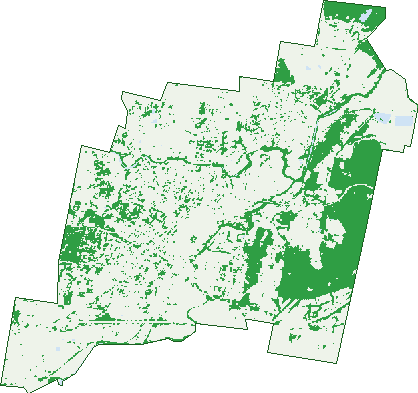
Green: 10 m cells where trees dominate, satellite 2021. Blue: water. The line is the suburb boundary.
| Canopy share, 1 m canopy height map, 2020 | 12.8% |
|---|---|
| Land with trees, 10 m satellite map, 2021 | 25.1% |
Demographics
Unemployment 4.6% · Labour-force participation 56.6%
Population by age in Goulburn
| 0-4 | 1,431 |
|---|---|
| 5-14 | 2,952 |
| 15-19 | 1,249 |
| 20-24 | 1,400 |
| 25-34 | 3,348 |
| 35-44 | 2,809 |
| 45-54 | 2,837 |
| 55-64 | 2,945 |
| 65-74 | 2,616 |
| 75-84 | 1,661 |
| 85+ | 717 |
Dwelling types in Goulburn
| House | 7,804 |
|---|---|
| Townhouse | 1,027 |
| Apartment | 359 |
| Other | 71 |
Households by weekly income in Goulburn
| <$650 | 1,914 |
|---|---|
| $650-1,499 | 2,697 |
| $1,500-2,999 | 2,734 |
| $3,000+ | 1,341 |
Top ancestries in Goulburn
| Australian | 9,889 |
|---|---|
| English | 9,865 |
| Irish | 3,129 |
| Scottish | 2,374 |
| Ancestry NS | 2,008 |
| Other | 1,461 |
Housing tenure in Goulburn
| Owned | 3,041 |
|---|---|
| Mortgage | 2,792 |
| Rented | 3,157 |
| Other | 146 |
Cars per household in Goulburn
| 0 | 710 |
|---|---|
| 1 | 3,573 |
| 2 | 3,108 |
| 3 | 1,134 |
| 4+ | 594 |
Commute to work in Goulburn
| Car | 7,993 |
|---|---|
| Train | 4 |
| Bus | 35 |
| Tram/ferry | 0 |
| Walked | 349 |
| Bicycle | 31 |
| Home | 725 |
Top countries of birth in Goulburn
| England | 444 |
|---|---|
| New Zealand | 230 |
| India | 211 |
| Philippines | 176 |
| Nepal | 144 |
| China | 113 |
Languages used at home in Goulburn
| Nepali | 168 |
|---|---|
| Mandarin | 123 |
| Malayalam | 90 |
| Greek | 74 |
| Punjabi | 72 |
| Hindi | 56 |
Birds & Wildlife Nearby
69,922 bird observations recorded near Goulburn — most often seen:
- Australian Magpie (4,416)
- Magpie-lark (4,220)
- Little Raven (3,760)
- Pied Currawong (3,699)
- Red Wattlebird (3,387)
- Eurasian Coot (2,921)
- Common Myna (2,746)
- Crested Pigeon (2,575)
- Sulphur-crested Cockatoo (2,534)
- Superb Fairy-wren (2,490)
- Pacific Black Duck (2,486)
- Dusky Moorhen (2,448)
- Common Starling (2,332)
Show all 30 birds recorded near Goulburn
- Galah (2,267)
- House Sparrow (2,196)
- Crimson Rosella (2,067)
- Little Corella (1,963)
- Australian Wood Duck (1,913)
- Grey Teal (1,867)
- Grey Butcherbird (1,816)
- Eurasian Blackbird (1,762)
- Australian White Ibis (1,738)
- Rainbow Lorikeet (1,687)
- Masked Lapwing (1,686)
- Willie Wagtail (1,594)
- White-faced Heron (1,546)
- Red-rumped Parrot (1,491)
- Noisy Miner (1,489)
- Yellow-faced Honeyeater (1,459)
- Little Pied Cormorant (1,367)
Sightings reported by observers, not a survey, so the counts show what people record rather than what lives here. Source: Atlas of Living Australia.
Nearby Suburbs
The closest suburbs to Goulburn:
- Run-o-waters (5.2 km)
- Brisbane Grove (5.7 km)
- Baw Baw (7.3 km)
- Kingsdale (7.3 km)
- Boxers Creek (10.2 km)
- Gundary (12 km)
- Towrang (12.7 km)
- Yarra (13 km)
Embed this suburb
Add this free Goulburn stat card to your own site — just copy the code:
Preview:
Cite this page
Quoting these figures? Copy the credit line:
Keep an eye on Goulburn
One email when this data meaningfully changes — new census figures, prices, rankings. No spam, unsubscribe anytime.
Streets
- Abbey Road (30)
- Ada Street (79)
- Adam Street (16)
- Addison Lane (9)
- Addison Street (206)
- Albert Street (102)
- Albion Street (46)
- Allison Street (60)
- Amaroo Place (30)
- Amber Court (15)
- Anembo Close (15)
- Angela Place (10)
- Apex Circle (27)
- Arcade Lane (1)
- Argyle Mall (37)
- Argyle Street (37)
- Arnheim Street (13)
- Arthur Street (1)
- Ash Close (5)
- Aston Martin Drive (65)
- Atkinson Crescent (7)
- Auburn Street (593)
- Audubon Crescent (22)
- Australia Street (16)
- Avoca Street (62)
- Ball Place (7)
- Ballanya Avenue (41)
- Ballina Street (10)
- Banksia Way (21)
- Baptiste Place (12)
- Barber Street (8)
- Barlow Place (2)
- Barry Crescent (31)
- Bathurst Street (13)
- Baxter Drive (11)
- Baxter Place (12)
- Bellevue Street (44)
- Belmore Street (44)
- Ben Bullen Place (4)
- Ben Street (50)
- Benjamin Place (11)
- Benlin Court (4)
- Bennett Street (14)
- Bent Street (1)
- Beppo Street (25)
- Betts Street (18)
- Beverly Close (19)
- Bigwood Place (31)
- Bishop Street (37)
- Blackshaw Road (7)
- Blakelys Road (27)
- Bolong Place (15)
- Bonneville Boulevard (111)
- Boomerang Drive (21)
- Bourke Street (210)
- Box Avenue (2)
- Bradford Drive (35)
- Bradley Street (123)
- Braidwood Road (55)
- Brendas Drive (22)
- Brennan Drive (13)
- Brewer Street (23)
- Bridge Street (8)
- Briggs Street (32)
- Brisbane Grove (7)
- Brooklands Circuit (111)
- Broughton Street (32)
- Brownhill Street (9)
- Bruce Street (13)
- Bryant Street (6)
- Buffalo Crescent E (19)
- Buffalo Crescent N (16)
- Buffalo Crescent S (3)
- Bullamalita Road (1)
- Bungonia Road (36)
- Burge Street (11)
- Burrows Close (6)
- Butler Place (5)
- Cahill Place (14)
- Calasanctius Street (2)
- Caoura Crescent (37)
- Caoura Place (8)
- Carmella Drive (29)
- Carr Street (8)
- Carramar Way (14)
- Carroll Place (7)
- Cartwright Place (19)
- Cathcart Street (107)
- Cemetery Street (7)
- Chantilly Court (27)
- Chantry Street (68)
- Charlotte Street (16)
- Chatsbury Street (89)
- Chesterton Street (32)
- Chinamans Lane (2)
- Chisholm Street (53)
- Chiswick Street (12)
- Church Street (39)
- Churchill Street (48)
- Citizen Street (97)
- City View Road (9)
- Clancy Place (14)
- Clifford Street (149)
- Clinton Lane (1)
- Clinton Street (283)
- Clure Place (8)
- Clyde Street (39)
- Cohen Place (13)
- Cole Street (31)
- College Street (3)
- Colvin Place (34)
- Combermere Street (160)
- Common Street (37)
- Confoy Place (5)
- Constantina Circuit (50)
- Cooinda Close (8)
- Coolowyn Road (3)
- Cooma Avenue (10)
- Copford Road (32)
- Coromandel Street (111)
- Cottonwood Avenue (24)
- Cove Street (6)
- Cowper Street (332)
- Cowrang Place (3)
- Craig Street (18)
- Cressy Street (21)
- Crestwood Drive (47)
- Crookwell Road (24)
- Crundwell Street (15)
- Cullinane Close (3)
- Dallas Tidyman Drive (3)
- Dalley Street (61)
- Dandarbong Crescent (8)
- Darcy Crescent (29)
- Davies Crescent (9)
- Day Street (31)
- Deccan Street (85)
- Denison Street (6)
- Derwent Street (5)
- Dewhirst Street (37)
- Dianella Place (6)
- Dimitri Street (12)
- Dixon Street (43)
- Donnelly Crescent (13)
- Dossie Street (1)
- Drinkwater Drive (22)
- Drummond Street (15)
- Duchess Place (8)
- Ducks Lane (14)
- Duffy Road (3)
- Duke Street (22)
- Dunne Close (2)
- East Street (19)
- Eaton Street (1)
- Edward Street (13)
- Eldon Street (22)
- Eleanor Street (79)
- Elizabeth Street (61)
- Ellesmere Street (10)
- Elm Street (16)
- Emma Street (60)
- Emmerson Street (16)
- Endeavour Avenue (29)
- Erith Street (7)
- Evangelista Street (42)
- Evans Street (24)
- Faithfull Street (189)
- Farm Road (2)
- Farquhar Street (2)
- Fenwick Crescent (22)
- Fenwick Street (1)
- Fife Place (14)
- Finlay Road (81)
- Fitzpatrick Street (33)
- Fitzroy Street (77)
- Forbes Street (7)
- Foster Street (10)
- Fox Close (10)
- Francis Street (41)
- Franklin Street (13)
- Fraser Close (7)
- Furner Street (24)
- Gale Place (6)
- Gallaher Place (9)
- Gardiner Road (41)
- Garfield Avenue (31)
- Garroorigang Road (4)
- Geoghegan Drive (2)
- George Street (49)
- Gerathy Street (33)
- Gertrude Street (12)
- Gibson Street (132)
- Gilmore Street (32)
- Glebe Avenue (25)
- Glebe Street (4)
- Glendare Crescent (9)
- Glenelg Street (16)
- Godfrey Street (22)
- Goldsmith Street (152)
- Golf Avenue (2)
- Goorawin Place (8)
- Gorman Road (22)
- Gourock Avenue (47)
- Grabben Gullen Road (2)
- Grafton Street (136)
- Grant Parade (26)
- Gray Avenue (10)
- Green Valley Road (106)
- Greenaway Place (6)
- Grimston Circuit (21)
- Grunsell Crescent (19)
- Gulson Street (30)
- Gumnut Lane (6)
- Gundary Street (25)
- Hampden Street (26)
- Hampshire Lane (13)
- Harris Street (1)
- Hawkins Place (6)
- Hawthorne Street (11)
- Hazelwood Place (16)
- Healey Street (36)
- Heath Street (23)
- Henderson Street (11)
- Henry Street (18)
- Herbert Street (1)
- Hercules Street (39)
- Hetherington Street (30)
- High Street (28)
- Hill Street (50)
- Hillview Road (9)
- Hinchcliffe Close (16)
- Hoddle Avenue (29)
- Hodgson Street (4)
- Hogg Place (18)
- Holland Street (11)
- Hollis Avenue (33)
- Horne Square (9)
- Hoskins Street (43)
- Hovell Street (56)
- Howard Boulevard (32)
- Hume Highway (3)
- Hume Street (192)
- Hunter Street (42)
- Hurrell Street (8)
- Hurst Street (27)
- Huxtable Place (26)
- Ibis Road (12)
- Indian Avenue (47)
- Ivy Lea Place (39)
- Jacqua Avenue (50)
- James Place (14)
- Joanna Place (10)
- Jockey Court (12)
- John Street (23)
- Joshua Street (132)
- Jubilee Avenue (17)
- Kadwell Street (15)
- Kavanagh Street (28)
- Kelly Place (6)
- Kelso Street (36)
- Kenmore Street (29)
- Kent Street (17)
- Kerr Place (10)
- Kidd Circuit (91)
- King Street (6)
- Kingfisher Road (8)
- Kinghorne Street (200)
- Kings Way (12)
- Kippilaw Road (5)
- Kirke Place (7)
- Knox Street (58)
- Komungla Crescent (20)
- Konak Street (2)
- Lagoon Street (181)
- Lamarra Place (18)
- Lambert Drive (10)
- Lanigan Lane (4)
- Lansdowne Place (7)
- Lansdowne Street (113)
- Lawford Lane (5)
- Lawrenny Avenue (13)
- Ledger Street (21)
- Leeson Street (10)
- Leonard Rise (6)
- Liguori Place (6)
- Lilac Place (1)
- Lillkar Road (9)
- Lions Place (4)
- Lisgar Street (35)
- Lithgow Street (24)
- Little Addison Street (9)
- Little Bourke Street (5)
- Llewellyn Avenue (14)
- Lockyer Street (31)
- Loder Street (8)
- Long Street (81)
- Lorne Street (38)
- Lovet Street (18)
- Lower Sterne Street (15)
- Lucas Close (10)