Glenmore Park NSW 2745
9,741 addresses · 370 streets
Lindsay Electorate › Penrith LGA › Glenmore Park · 50 km from Sydney
📦 Thinking of moving here? Read the Glenmore Park moving guide

Living Here
A family suburb at the foot of the Blue Mountains in Sydney's outer west, Glenmore Park is built around detached homes. Households average 3.2 people and the median age is 34. Median household income is high at $2,526 a week, with rent around $480.
Glenmore Park is a suburb of New South Wales, home to about 25,021 people, with a median age of 34. The typical household earns around $2,526 a week, with median rent near $480 a week. Most homes are houses. About 77% of households own their home and 23% rent. Most workers drive to work. Common community backgrounds include Australian, English, Irish. On the ABS socio-economic scale it sits in decile 9 of 10 nationally — a relatively advantaged area.
Over time — Census 2001 → 2021
Dashed line: district figures for the Glenmore Park - Regentville statistical area (SA2), the smallest area the ABS published before 2011. Solid line: Glenmore Park itself.
Getting Around & Local Services
4 supermarkets
2 pharmacies
4 doctors & medical clinics
1 dentist
2 post offices
2 playgrounds
1 dog park
1 bakery
1 electrician
1 carpenter
Getting around. Train station: Lapstone, 3.9 km north-west · Bus interchange: Western Shuttle Bus Stop, 5.1 km north-east · Airport: Western Sydney International Airport, 10.8 km south.
Socio-economic Standing
Deciles from 1 (lowest) to 10 (highest), against all Australian suburbs. The overall figure weighs advantage and disadvantage together; economic resources counts income and housing, and education & jobs counts qualifications and occupation. They often differ. Source: ABS SEIFA 2021.
Tree cover
🌳 Tree canopy: 7.1% share of land under canopy · satellite map, 2020
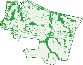
Green: 10 m cells where trees dominate, satellite 2021. Blue: water. The line is the suburb boundary.
| Canopy share, 1 m canopy height map, 2020 | 7.1% |
|---|---|
| Surveyed canopy, Greater Sydney aerial survey, 2019 | 7.9% |
| Land with trees, 10 m satellite map, 2021 | 18.7% |
Demographics
Unemployment 3% · Labour-force participation 73.6%
Population by age in Glenmore Park
| 0-4 | 1,886 |
|---|---|
| 5-14 | 4,071 |
| 15-19 | 1,926 |
| 20-24 | 1,670 |
| 25-34 | 3,237 |
| 35-44 | 3,899 |
| 45-54 | 3,548 |
| 55-64 | 2,602 |
| 65-74 | 1,520 |
| 75-84 | 525 |
| 85+ | 142 |
Dwelling types in Glenmore Park
| House | 7,067 |
|---|---|
| Townhouse | 575 |
| Apartment | 153 |
| Other | 0 |
Households by weekly income in Glenmore Park
| <$650 | 497 |
|---|---|
| $650-1,499 | 1,297 |
| $1,500-2,999 | 2,706 |
| $3,000+ | 2,902 |
Top ancestries in Glenmore Park
| Australian | 9,438 |
|---|---|
| English | 8,215 |
| Other | 3,387 |
| Irish | 2,212 |
| Scottish | 1,874 |
| Indian | 1,111 |
Housing tenure in Glenmore Park
| Owned | 1,782 |
|---|---|
| Mortgage | 4,163 |
| Rented | 1,770 |
| Other | 38 |
Cars per household in Glenmore Park
| 0 | 132 |
|---|---|
| 1 | 1,836 |
| 2 | 3,518 |
| 3 | 1,386 |
| 4+ | 874 |
Commute to work in Glenmore Park
| Car | 6,910 |
|---|---|
| Train | 88 |
| Bus | 43 |
| Tram/ferry | 0 |
| Walked | 59 |
| Bicycle | 5 |
| Home | 4,107 |
Top countries of birth in Glenmore Park
| India | 904 |
|---|---|
| England | 721 |
| Philippines | 471 |
| New Zealand | 322 |
| South Africa | 145 |
| China | 133 |
Languages used at home in Glenmore Park
| Punjabi | 630 |
|---|---|
| Arabic | 340 |
| Hindi | 246 |
| Tagalog | 220 |
| Mandarin | 184 |
| Malayalam | 173 |
Birds & Wildlife Nearby
25,630 bird observations recorded near Glenmore Park — most often seen:
- Rainbow Lorikeet (2,048)
- Noisy Miner (1,818)
- Australian Magpie (1,555)
- Common Myna (1,408)
- Magpie-lark (1,290)
- Australian Raven (1,280)
- Sulphur-crested Cockatoo (930)
- Australian Wood Duck (843)
- Superb Fairy-wren (772)
- Pied Currawong (761)
- Bell Miner (753)
- Grey Butcherbird (745)
- Spotted Turtle-dove (742)
Show all 30 birds recorded near Glenmore Park
- Crested Pigeon (727)
- Pacific Black Duck (703)
- Welcome Swallow (703)
- Dusky Moorhen (682)
- Red-whiskered Bulbul (677)
- Willie Wagtail (652)
- Australian White Ibis (646)
- Common Starling (610)
- Little Corella (605)
- Southern Magpie-lark (600)
- Eurasian Blackbird (599)
- Masked Lapwing (592)
- Galah (587)
- Southern Noisy Miner (584)
- Rock Dove (575)
- Grey Fantail (574)
- Eastern Australian Raven (569)
Sightings reported by observers, not a survey, so the counts show what people record rather than what lives here. Source: Atlas of Living Australia.
Nearby Suburbs
The closest suburbs to Glenmore Park:
- Regentville (2.5 km)
- Jamisontown (2.8 km)
- South Penrith (2.9 km)
- Lapstone (4.1 km)
- Leonay (4.1 km)
- Penrith (4.9 km)
- Emu Plains (4.9 km)
- Mulgoa (5.1 km)
Embed this suburb
Add this free Glenmore Park stat card to your own site — just copy the code:
Preview:
Cite this page
Quoting these figures? Copy the credit line:
Keep an eye on Glenmore Park
One email when this data meaningfully changes — new census figures, prices, rankings. No spam, unsubscribe anytime.
Streets
- Aberdeen Circuit (56)
- Acacia Avenue (18)
- Allison Drive (37)
- Alston Street (23)
- Altavista Rise (6)
- Amber Oak Road (14)
- Aspect Crescent (31)
- Aster Close (13)
- Atkinson Close (15)
- Avalon Crescent (14)
- Azalea Court (10)
- Ballybunnion Terrace (28)
- Bangalla Parade (40)
- Bangaroo Avenue (10)
- Bangu Place (12)
- Banjo Paterson Close (21)
- Baraba Close (14)
- Bardo Street (12)
- Barron Field Drive (26)
- Bayldon Place (16)
- Beal Place (10)
- Becke Court (13)
- Begonia Court (37)
- Berril Place (23)
- Bija Drive (57)
- Bimbadeen Way (11)
- Bindee Close (16)
- Binnit Place (9)
- Binyang Avenue (89)
- Birkdale Circuit (20)
- Black Wattle Drive (12)
- Blue Hills Drive (11)
- Blue View Terrace (36)
- Bluebell Close (37)
- Bluestone Drive (71)
- Bluewren Close (10)
- Boake Close (5)
- Boldero Crescent (30)
- Bradley Street (188)
- Brady Place (15)
- Bradyn Place (9)
- Branksome Way (20)
- Briarwood Avenue (11)
- Brigadoon Avenue (23)
- Broadlands Avenue (7)
- Bronte Way (5)
- Budge Close (23)
- Bujan Street (44)
- Bukari Way (8)
- Bulbi Place (1)
- Bulu Drive (36)
- Buna Close (18)
- Bunda Place (16)
- Bundeluk Crescent (28)
- Bunya Place (9)
- Burra Close (25)
- Burraga Place (15)
- Bursaria Crescent (64)
- Butcherbird Place (31)
- Buyu Road (42)
- Byrne Way (5)
- Camellia Avenue (108)
- Candlebark Circuit (51)
- Capstone Terrace (16)
- Carex Close (12)
- Carnoustie Place (5)
- Cartwright Place (20)
- Cascade Avenue (21)
- Cashmere Road (31)
- Castlerock Avenue (21)
- Cedar Court (6)
- Charbray Avenue (27)
- Clearview Terrace (21)
- Coco Drive (37)
- Condor Place (20)
- Cooee Avenue (55)
- Coolabah Crescent (29)
- Corella Crescent (22)
- Cormorant Crescent (14)
- Coronet Terrace (8)
- Corridale Road (36)
- Corvus Close (12)
- Cotula Place (9)
- Cowan Place (19)
- Crestwood Avenue (12)
- Crimson Oak Way (7)
- Crossley Avenue (14)
- Curlew Court (6)
- Cyperus Place (10)
- Daffodil Place (9)
- Dara Crescent (36)
- Darug Avenue (78)
- Daviesia Place (8)
- Deerubbin Drive (76)
- Denya Close (14)
- Devaney Avenue (24)
- Dillwynia Drive (38)
- Domus Street (21)
- Dorper Crescent (6)
- Dorrington Place (13)
- Duncan Close (11)
- Dungara Crescent (36)
- Dunna Place (31)
- Durali Road (57)
- Dutba Place (12)
- Dutton Place (22)
- Dyson Place (8)
- Edgewater Drive (27)
- Eliza Place (14)
- Englewood Way (6)
- Ernstine Hill Close (13)
- Esson Place (8)
- Ewan James Drive (32)
- Fairwater Court (9)
- Fairywren Close (38)
- Ferntree Close (25)
- Firestone Crescent (23)
- Fitzgerald Place (22)
- Flitcroft Place (12)
- Floribunda Avenue (151)
- Foothills Terrace (33)
- Forestwood Drive (98)
- Freesia Place (13)
- Friarbird Crescent (47)
- Frontier Street (39)
- Fullerton Place (12)
- Gallinulla Place (13)
- Galloway Road (29)
- Garswood Road (60)
- Gemalong Place (19)
- Geranium Close (21)
- Giles Close (15)
- Gili Place (11)
- Gilmore Close (20)
- Gleneagles Way (19)
- Glengarry Drive (95)
- Glenholme Drive (13)
- Glenmore Parkway (81)
- Glenmore Ridge Drive (476)
- Grandeur Crescent (7)
- Greenlink Drive (20)
- Gunara Terrace (23)
- Gunyah Drive (45)
- Guru Place (7)
- Harold Bentleys Way (18)
- Harpur Close (11)
- Harriett Close (19)
- Harrower Place (6)
- Harwood Circuit (57)
- Hasluck Place (4)
- Hassall Way (20)
- Hazel Bark Road (15)
- Hereford Avenue (21)
- Heritage Court (10)
- Highdale Terrace (59)
- Highlands Avenue (18)
- Holland Court (4)
- Honeysuckle Avenue (19)
- Horti Street (16)
- Hovea Close (13)
- Huntingdale Drive (35)
- Iris Court (9)
- Isca Place (7)
- Jacana Way (11)
- Jacaranda Terrace (5)
- James Riley Drive (53)
- Jarra Crescent (13)
- Jasmine Close (14)
- Jessup Place (10)
- Jillak Close (34)
- Jimbi Place (26)
- Jimbuck Close (9)
- Jindalee Place (12)
- Jirang Place (22)
- Jirramba Court (36)
- Jonquil Place (10)
- Kabu Court (5)
- Kalua Place (17)
- Karabi Close (19)
- Karingal Court (16)
- Karuk Street (6)
- Kenneth Slessor Drive (69)
- Kiber Drive (98)
- Killarney Avenue (13)
- Kingsfield Avenue (21)
- Knox Street (41)
- Kobina Avenue (59)
- Kookaburra Crescent (29)
- Kukundi Drive (57)
- Kulaman Crescent (14)
- Kuma Place (8)
- Kumbara Close (46)
- Kuraji Close (17)
- Kurpun Place (14)
- Kutmut Street (15)
- Kyarra Terrace (12)
- Kylie Tennant Close (15)
- Lady Jamison Drive (43)
- Laguna Drive (25)
- Lakewood Terrace (23)
- Lang Place (5)
- Langley Avenue (19)
- Laurel Court (6)
- Lavender Close (23)
- Lehmann Avenue (23)
- Lily Court (9)
- Linara Circuit (29)
- Lineata Place (11)
- Litoria Place (9)
- Loch Avenue (20)
- Lucidus Place (4)
- Luttrell Street (76)
- Lyora Street (15)
- Lytham Court (5)
- Mackenzie Avenue (14)
- Magpie Place (12)
- Maidstone Place (6)
- Mandalong Terrace (14)
- Manifold Crescent (18)
- Mapleview Lane (3)
- Marcus Clarke Crescent (41)
- Mari Close (33)
- Marie Pitt Place (10)
- Marigold Close (26)
- Massey Way (4)
- Merion Court (6)
- Middlebrook Rise (19)
- Middleridge Drive (20)
- Midin Close (43)
- Miles Franklin Close (13)
- Minnaville Close (3)
- Minnek Close (32)
- Mirri Place (8)
- Mogo Place (6)
- Monarch Circuit (46)
- Monteray Terrace (27)
- Morrison Street (8)
- Mort Place (5)
- Muirfield Crescent (24)
- Mulgoa Road (18)
- Muru Drive (134)
- Musselburgh Close (15)
- Naoi Place (8)
- Narrabeen Place (16)
- Narran Place (13)
- Nea Close (5)
- Neilson Close (14)
- Nindi Crescent (31)
- Norton Place (6)
- Oakmont Avenue (4)
- Oriole Street (45)
- Oriri Avenue (19)
- Orlander Avenue (18)
- Ormonde Close (22)
- Osprey Avenue (27)
- Panicum Place (5)
- Panton Close (15)
- Paperbark Close (42)
- Parakeet Grove (14)
- Pardalote Place (42)
- Parkway Avenue (10)
- Parry Way (6)
- Peak Place (4)
- Pinehurst Avenue (19)
- Pinewood Avenue (12)
- Pinnacle Ridge (4)
- Poa Place (9)
- Pratia Place (11)
- Prestwick Terrace (16)
- Pritchard Place (24)
- Prospect Avenue (30)
- Prunus Close (22)
- Punka Place (10)
- Rainbow Close (28)
- Randall Street (34)
- Regentville Road (91)
- Richardson Place (17)
- Riddell Close (7)
- Ridgetop Drive (128)
- Risus Avenue (23)
- Riverflat Drive (31)
- Riviera Place (11)
- Robin Place (5)
- Rosea Place (6)
- Rosecrea Court (29)
- Rosemary Crescent (4)
- Roseville Terrace (17)
- Saddler Way (35)
- Sandstone Avenue (7)
- Satinwood Road (15)
- School House Road (23)
- Scrubwren Place (11)
- Shale Hill Drive (61)
- Shearwater Drive (55)
- Sheoak Place (11)
- Shetland Avenue (17)
- Shiels Court (6)
- Shorthorn Avenue (25)
- Silver Gum Avenue (13)
- Silvereye Close (19)