Gerringong NSW 2534
2,677 addresses · 82 streets
Gilmore Electorate › Kiama LGA › Gerringong · 104 km from Sydney
📦 Thinking of moving here? Read the Gerringong moving guide

Living Here
Gerringong is a suburb of New South Wales, home to about 4,165 people, with a median age of 46. The typical household earns around $1,899 a week, with median rent near $500 a week. Most homes are houses. About 77% of households own their home and 20% rent. Most workers drive to work. Common community backgrounds include English, Australian, Irish. On the ABS socio-economic scale it sits in decile 9 of 10 nationally — a relatively advantaged area.
Over time — Census 2001 → 2021
Dashed line: district figures for the Kiama Hinterland - Gerringong statistical area (SA2), the smallest area the ABS published before 2011. Solid line: Gerringong itself.
Getting Around & Local Services
1 school
5 cafés & restaurants
1 supermarket
2 beaches
2 Catholic churches
1 medical clinic
1 library
2 post offices
1 golf club
Getting around. Train station: Gerringong, 750 m west · Airport: Shellharbour Airport, 20.9 km north.
Socio-economic Standing
Deciles from 1 (lowest) to 10 (highest), against all Australian suburbs. The overall figure weighs advantage and disadvantage together; economic resources counts income and housing, and education & jobs counts qualifications and occupation. They often differ. Source: ABS SEIFA 2021.
Tree cover
🌳 Tree canopy: 4.8% share of land under canopy · satellite map, 2020
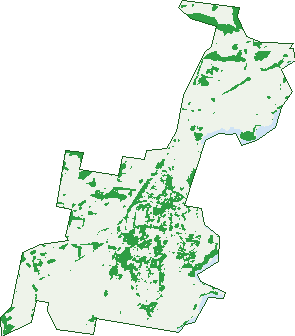
Green: 10 m cells where trees dominate, satellite 2021. Blue: water. The line is the suburb boundary.
| Canopy share, 1 m canopy height map, 2020 | 4.8% |
|---|---|
| Land with trees, 10 m satellite map, 2021 | 17.9% |
Demographics
Unemployment 3.6% · Labour-force participation 58.1%
Population by age in Gerringong
| 0-4 | 230 |
|---|---|
| 5-14 | 537 |
| 15-19 | 241 |
| 20-24 | 163 |
| 25-34 | 370 |
| 35-44 | 455 |
| 45-54 | 520 |
| 55-64 | 570 |
| 65-74 | 552 |
| 75-84 | 352 |
| 85+ | 170 |
Dwelling types in Gerringong
| House | 1,174 |
|---|---|
| Townhouse | 224 |
| Apartment | 79 |
| Other | 3 |
Households by weekly income in Gerringong
| <$650 | 204 |
|---|---|
| $650-1,499 | 383 |
| $1,500-2,999 | 408 |
| $3,000+ | 393 |
Top ancestries in Gerringong
| English | 1,914 |
|---|---|
| Australian | 1,749 |
| Irish | 665 |
| Scottish | 535 |
| Other | 213 |
| Ancestry NS | 150 |
Housing tenure in Gerringong
| Owned | 656 |
|---|---|
| Mortgage | 472 |
| Rented | 291 |
| Other | 51 |
Cars per household in Gerringong
| 0 | 61 |
|---|---|
| 1 | 473 |
| 2 | 633 |
| 3 | 189 |
| 4+ | 111 |
Commute to work in Gerringong
| Car | 1,035 |
|---|---|
| Train | 3 |
| Bus | 0 |
| Tram/ferry | 0 |
| Walked | 47 |
| Bicycle | 4 |
| Home | 475 |
Top countries of birth in Gerringong
| England | 203 |
|---|---|
| New Zealand | 59 |
| United States | 25 |
| South Africa | 18 |
| Germany | 16 |
| Italy | 14 |
Languages used at home in Gerringong
| Italian | 18 |
|---|---|
| Spanish | 16 |
| French | 12 |
| German | 10 |
| Thai | 10 |
| Greek | 9 |
Birds & Wildlife Nearby
16,763 bird observations recorded near Gerringong — most often seen:
- Silver Gull (1,223)
- Crested Tern (922)
- Welcome Swallow (883)
- Great Cormorant (855)
- Australian Magpie (793)
- Australian Pelican (689)
- Australian Raven (671)
- New Holland Honeyeater (656)
- Red Wattlebird (626)
- White-faced Heron (604)
- Pied Cormorant (603)
- Magpie-lark (580)
- Willie Wagtail (513)
Show all 30 birds recorded near Gerringong
- Little Pied Cormorant (504)
- Nankeen Kestrel (503)
- Australasian Gannet (492)
- Superb Fairy-wren (486)
- Rainbow Lorikeet (483)
- Galah (470)
- Little Black Cormorant (456)
- Little Wattlebird (443)
- Chestnut Teal (433)
- Common Starling (422)
- Sooty Oystercatcher (376)
- Common Myna (363)
- Australian Pied Oystercatcher (361)
- Great Egret (357)
- White-bellied Sea-eagle (338)
- Pied Currawong (336)
- Australian White Ibis (322)
Sightings reported by observers, not a survey, so the counts show what people record rather than what lives here. Source: Atlas of Living Australia.
Nearby Suburbs
The closest suburbs to Gerringong:
- Werri Beach (1.4 km)
- Rose Valley (3 km)
- Gerroa (3.2 km)
- Willow Vale (3.3 km)
- Toolijooa (4.5 km)
- Saddleback Mountain (5.6 km)
- Kiama Heights (5.9 km)
- Foxground (6.4 km)
Embed this suburb
Add this free Gerringong stat card to your own site — just copy the code:
Preview:
Cite this page
Quoting these figures? Copy the credit line:
Keep an eye on Gerringong
One email when this data meaningfully changes — new census figures, prices, rankings. No spam, unsubscribe anytime.
Streets
- Aldinga Avenue (17)
- Alne Bank Lane (3)
- Archibald Road (15)
- Armstrong Avenue (71)
- Baileys Road (2)
- Barclay Street (19)
- Barremma Place (4)
- Belinda Street (415)
- Bergin Street (17)
- Blackwall Street (10)
- Blackwood Street (49)
- Boona Avenue (12)
- Bridges Road (271)
- Brook Street (44)
- Burnett Avenue (70)
- Burra Street (9)
- Cambewarra Place (24)
- Camira Avenue (10)
- Campbell Street (39)
- Carinya Way (24)
- Chippewa Road (8)
- Chisholm Road (5)
- Chittick Place (15)
- Coal Street (35)
- Cooke Place (15)
- Coolangatta Avenue (20)
- Cope Place (6)
- Craig Place (8)
- Croft Place (31)
- Echo Road (11)
- Elambra Parade (34)
- Fern Street (271)
- Figtree Lane (1)
- Frolic Street (7)
- Fuller Street (3)
- Geering Street (46)
- Gowan Place (25)
- Gray Street (2)
- Greta Street (60)
- Henry Lee Drive (26)
- Hindmarsh Street (1)
- Illoura Place (8)
- Ino Lane (11)
- Jubilee Avenue (16)
- Jupiter Street (58)
- Kareela Place (8)
- Kilburnie Place (8)
- Koraaga Road (10)
- Margaret Street (2)
- Mermaid Place (5)
- Millewa Avenue (14)
- Morrow Street (31)
- Myamba Street (6)
- Neptune Street (32)
- Nile Close (24)
- Noble Street (90)
- O'connell Place (10)
- Osborne Street (58)
- Parkes Street (7)
- Percy Street (16)
- Princes Highway (32)
- Robson Place (5)
- Rowlins Road (66)
- Sandy Wha Road (31)
- Saxonia Road (26)
- Scotia Street (10)
- Sharpe Place (24)
- Sharwood Place (25)
- Short Street (9)
- Sims Road (12)
- Spec Lane (7)
- Tasman Drive (21)
- Toorak Place (5)
- Union Way (57)
- Victoria Street (18)
- Watkins Close (5)
- Wells Street (23)
- Willawa Avenue (45)
- Willowbank Place (47)
- Willowvale Road (1)
- Wilson Avenue (36)
- Wingeewah Road (3)