Figtree NSW 2525
5,469 addresses · 136 streets
Cunningham Electorate › Wollongong LGA › Figtree · 71 km from Sydney
📦 Thinking of moving here? Read the Figtree moving guide

Living Here
Figtree is a suburb of New South Wales, home to about 12,335 people, with a median age of 40. The typical household earns around $2,042 a week, with median rent near $430 a week. Most homes are houses. About 81% of households own their home and 18% rent. Most workers drive to work. Common community backgrounds include Australian, English, Scottish. On the ABS socio-economic scale it sits in decile 9 of 10 nationally — a relatively advantaged area.
Over time — Census 2001 → 2021
Dashed line: district figures for the Figtree - Keiraville statistical area (SA2), the smallest area the ABS published before 2011. Solid line: Figtree itself.
Getting Around & Local Services
2 pharmacies
1 medical clinic
2 childcare & kindergartens
8 service stations
1 hardware store
2 hairdressers
1 electrician
1 plumber
Getting around. Train station: Unanderra, 2.4 km south · Railway halt: Lysaghts, 3.1 km south-east · Bus interchange: Station St opp Wollongong Station, 3.4 km east · Airport: Shellharbour Airport, 15.1 km south.
Socio-economic Standing
Deciles from 1 (lowest) to 10 (highest), against all Australian suburbs. The overall figure weighs advantage and disadvantage together; economic resources counts income and housing, and education & jobs counts qualifications and occupation. They often differ. Source: ABS SEIFA 2021.
Tree cover
🌳 Tree canopy: 28.8% share of land under canopy · satellite map, 2020
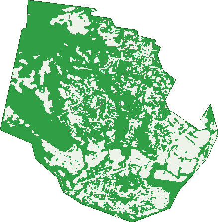
Green: 10 m cells where trees dominate, satellite 2021. Blue: water. The line is the suburb boundary.
| Canopy share, 1 m canopy height map, 2020 | 28.8% |
|---|---|
| Land with trees, 10 m satellite map, 2021 | 67.2% |
Demographics
Unemployment 4% · Labour-force participation 61.2%
Population by age in Figtree
| 0-4 | 722 |
|---|---|
| 5-14 | 1,705 |
| 15-19 | 875 |
| 20-24 | 776 |
| 25-34 | 1,259 |
| 35-44 | 1,625 |
| 45-54 | 1,687 |
| 55-64 | 1,343 |
| 65-74 | 1,197 |
| 75-84 | 820 |
| 85+ | 322 |
Dwelling types in Figtree
| House | 3,535 |
|---|---|
| Townhouse | 417 |
| Apartment | 181 |
| Other | 154 |
Households by weekly income in Figtree
| <$650 | 595 |
|---|---|
| $650-1,499 | 1,031 |
| $1,500-2,999 | 1,195 |
| $3,000+ | 1,251 |
Top ancestries in Figtree
| Australian | 4,159 |
|---|---|
| English | 4,075 |
| Other | 1,303 |
| Scottish | 1,222 |
| Irish | 1,116 |
| Italian | 833 |
Housing tenure in Figtree
| Owned | 1,747 |
|---|---|
| Mortgage | 1,695 |
| Rented | 748 |
| Other | 63 |
Cars per household in Figtree
| 0 | 184 |
|---|---|
| 1 | 1,230 |
| 2 | 1,840 |
| 3 | 605 |
| 4+ | 393 |
Commute to work in Figtree
| Car | 3,072 |
|---|---|
| Train | 11 |
| Bus | 25 |
| Tram/ferry | 0 |
| Walked | 58 |
| Bicycle | 19 |
| Home | 1,663 |
Top countries of birth in Figtree
| England | 405 |
|---|---|
| North Macedonia | 213 |
| China | 202 |
| India | 162 |
| Italy | 141 |
| New Zealand | 127 |
Languages used at home in Figtree
| Macedonian | 339 |
|---|---|
| Mandarin | 286 |
| Italian | 194 |
| Arabic | 188 |
| Greek | 168 |
| Serbian | 166 |
Birds & Wildlife Nearby
219,946 bird observations recorded near Figtree — most often seen:
- Rainbow Lorikeet (14,741)
- Sulphur-crested Cockatoo (13,351)
- Common Myna (12,919)
- Magpie-lark (11,000)
- Lewin's Honeyeater (10,845)
- Australian Raven (10,199)
- Grey Butcherbird (9,957)
- Little Wattlebird (9,945)
- Australian Magpie (9,559)
- Satin Bowerbird (8,531)
- Eastern Spinebill (8,334)
- Laughing Kookaburra (7,842)
- Noisy Miner (7,808)
Show all 30 birds recorded near Figtree
- Silver Gull (7,460)
- Eastern Whipbird (6,576)
- Spotted Turtle-dove (6,260)
- Australian King-parrot (6,202)
- Eastern Yellow Robin (5,565)
- Crimson Rosella (5,279)
- Welcome Swallow (5,201)
- Crested Pigeon (4,870)
- Grey Fantail (4,851)
- White-browed Scrubwren (4,652)
- Australian Wood Duck (4,545)
- Superb Fairy-wren (4,119)
- Red-whiskered Bulbul (4,047)
- Eurasian Blackbird (3,936)
- Pied Currawong (3,907)
- Silvereye (3,730)
- Dusky Moorhen (3,715)
Sightings reported by observers, not a survey, so the counts show what people record rather than what lives here. Source: Atlas of Living Australia.
Nearby Suburbs
The closest suburbs to Figtree:
- West Wollongong (1.8 km)
- Spring Hill (1.9 km)
- Mount Saint Thomas (1.9 km)
- Mangerton (1.9 km)
- Mount Keira (2.1 km)
- Cordeaux Heights (2.4 km)
- Unanderra (2.7 km)
- Coniston (2.7 km)
Embed this suburb
Add this free Figtree stat card to your own site — just copy the code:
Preview:
Cite this page
Quoting these figures? Copy the credit line:
Keep an eye on Figtree
One email when this data meaningfully changes — new census figures, prices, rankings. No spam, unsubscribe anytime.
Streets
- Abertillery Road (17)
- Alandale Avenue (48)
- Amaroo Avenue (24)
- Arkell Drive (28)
- Arrow Avenue (45)
- Arter Avenue (20)
- Avalon Terrace (4)
- Aviemore Place (22)
- Baker Crescent (32)
- Bangalay Street (15)
- Bellevue Road (181)
- Belwarra Avenue (20)
- Benney Avenue (28)
- Branch Avenue (56)
- Brentwood Avenue (41)
- Breynia Street (41)
- Brook Place (6)
- Burgess Avenue (40)
- Camden Grove (25)
- Cameron Place (20)
- Canaan Avenue (23)
- Cascarilla Street (21)
- Casuarina Place (6)
- Chislehurst Avenue (16)
- Cleverdon Crescent (23)
- Cobblers Avenue (57)
- Cordeaux Road (110)
- Coronata Drive (32)
- Cottonwood Crescent (20)
- Cranesbill Way (12)
- Cranford Lane (49)
- Cypress Avenue (35)
- Dalmeny Avenue (9)
- Darragh Drive (95)
- Day Avenue (12)
- Edgebury Road (18)
- Edmund Avenue (58)
- Eugena Place (11)
- Evelyn Avenue (22)
- Figtree Crescent (123)
- Foy Avenue (31)
- Gadsden Way (14)
- Gahnia Avenue (42)
- Garden Avenue (53)
- Gellatly Avenue (36)
- George Fuller Drive (39)
- Gibsons Road (121)
- Goodbury Avenue (20)
- Govett Crescent (35)
- Grafton Avenue (55)
- Greenhill Avenue (16)
- Hannah Close (10)
- Helicia Avenue (17)
- Hennessy Lane (29)
- Herne Street (22)
- Indigo Way (18)
- Jacaranda Avenue (246)
- Jalna Avenue (20)
- Janet Street (8)
- Jaylang Place (14)
- Karbo Street (31)
- Kerrawah Avenue (21)
- Kilbirnie Place (28)
- Kimmins Place (13)
- Koloona Avenue (79)
- Lamerton Drive (39)
- Langson Avenue (85)
- Lantarra Place (33)
- Lewis Drive (35)
- Lillian Place (8)
- Maculata Place (3)
- Mallangong Close (24)
- Manna Avenue (26)
- Marengo Avenue (17)
- Mark Street (30)
- Mary Avenue (17)
- Mcdonough Avenue (11)
- Mcgregor Place (15)
- Millbrook Road (9)
- Moab Place (5)
- Morinda Close (16)
- Mountain View Crescent (17)
- Murray Park Road (127)
- Musgrave Place (15)
- Nareena Avenue (2)
- Neave Avenue (12)
- Nebo Drive (59)
- Northview Terrace (47)
- O'briens Lane (14)
- O'briens Road (217)
- O'donnell Drive (151)
- Oleander Avenue (39)
- Outlook Drive (85)
- Partridge Place (13)
- Platypus Close (37)
- Preston Street (60)
- Princes Highway (303)
- Rachel Crescent (51)
- Rainforest Place (12)
- Redgum Forest Way (49)
- Risley Road (48)
- Rosegum Close (5)
- Rowan Place (10)
- Ryan Lane (24)
- Sampson Place (16)
- Satinwood Avenue (16)
- Seddon Street (32)
- Silkpod Street (26)
- Sleigh Street (25)
- Smyth Place (23)
- Sorensen Drive (57)
- Springfield Avenue (87)
- St George Avenue (14)
- St Marks Crescent (13)
- Stillness Road (18)
- Stockwell Place (17)
- Suttor Place (13)
- Terra Place (8)
- Terrie Avenue (45)
- The Avenue (28)
- Tigway Avenue (7)
- Truscott Place (8)
- Uralba Street (82)
- Valley Drive (91)
- Wade Street (25)
- Walang Avenue (106)
- Wallawa Street (9)
- Waterfall Way (16)
- Welford Place (8)
- Whelan Avenue (26)
- White Place (21)
- William Davies Drive (40)
- William Street (47)
- Woodlands Place (11)
- Woodrow Place (215)
- Zelang Avenue (66)