Ermington NSW 2115
6,171 addresses · 113 streets
Bennelong Electorate › Parramatta LGA › Ermington · 15 km from Sydney
📦 Thinking of moving here? Read the Ermington moving guide

Living Here
Ermington is a suburb of New South Wales, home to about 12,686 people, with a median age of 37. The typical household earns around $1,993 a week, with median rent near $420 a week. Most homes are houses. About 56% of households own their home and 43% rent. Most workers drive to work. Common community backgrounds include Australian, Chinese, English. On the ABS socio-economic scale it sits in decile 9 of 10 nationally — a relatively advantaged area.
Over time — Census 2001 → 2021
Dashed line: district figures for the Ermington - Rydalmere statistical area (SA2), the smallest area the ABS published before 2011. Solid line: Ermington itself.
Getting Around & Local Services
2 childcare & kindergartens
2 playgrounds
2 butchers
1 beauty salon
2 plumbers
1 carpenter
Getting around. Train station: Meadowbank, 2.9 km east · Metro station: Epping, 4.9 km north-east · Light rail stop: Dundas, 2.5 km north-west · Bus interchange: Parramatta EA, 3.2 km west · Ferry wharf: Rydalmere Ferry Wharf, 1.5 km south-west · Airport: Bankstown Airport, 13.9 km south-west.
Socio-economic Standing
Deciles from 1 (lowest) to 10 (highest), against all Australian suburbs. The overall figure weighs advantage and disadvantage together; economic resources counts income and housing, and education & jobs counts qualifications and occupation. They often differ. Source: ABS SEIFA 2021.
Tree cover
🌳 Tree canopy: 13.8% share of land under canopy · satellite map, 2020
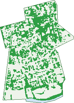
Green: 10 m cells where trees dominate, satellite 2021. Blue: water. The line is the suburb boundary.
| Canopy share, 1 m canopy height map, 2020 | 13.8% |
|---|---|
| Surveyed canopy, Greater Sydney aerial survey, 2019 | 20.0% |
| Land with trees, 10 m satellite map, 2021 | 40.6% |
Demographics
Unemployment 5.4% · Labour-force participation 58.7%
Population by age in Ermington
| 0-4 | 846 |
|---|---|
| 5-14 | 1,610 |
| 15-19 | 659 |
| 20-24 | 729 |
| 25-34 | 1,975 |
| 35-44 | 2,053 |
| 45-54 | 1,582 |
| 55-64 | 1,460 |
| 65-74 | 1,047 |
| 75-84 | 499 |
| 85+ | 231 |
Dwelling types in Ermington
| House | 2,579 |
|---|---|
| Townhouse | 904 |
| Apartment | 767 |
| Other | 10 |
Households by weekly income in Ermington
| <$650 | 709 |
|---|---|
| $650-1,499 | 889 |
| $1,500-2,999 | 1,225 |
| $3,000+ | 1,202 |
Top ancestries in Ermington
| Other | 2,423 |
|---|---|
| Australian | 2,391 |
| Chinese | 2,313 |
| English | 2,203 |
| Korean | 966 |
| Ancestry NS | 812 |
Housing tenure in Ermington
| Owned | 937 |
|---|---|
| Mortgage | 1,414 |
| Rented | 1,828 |
| Other | 37 |
Cars per household in Ermington
| 0 | 370 |
|---|---|
| 1 | 1,500 |
| 2 | 1,626 |
| 3 | 476 |
| 4+ | 241 |
Commute to work in Ermington
| Car | 2,209 |
|---|---|
| Train | 40 |
| Bus | 73 |
| Tram/ferry | 0 |
| Walked | 41 |
| Bicycle | 22 |
| Home | 2,201 |
Top countries of birth in Ermington
| China | 1,077 |
|---|---|
| South Korea | 716 |
| Lebanon | 264 |
| India | 248 |
| Philippines | 234 |
| Hong Kong | 224 |
Languages used at home in Ermington
| Mandarin | 1,173 |
|---|---|
| Korean | 929 |
| Cantonese | 713 |
| Arabic | 683 |
| Persian | 183 |
| Hindi | 125 |
Birds & Wildlife Nearby
233,199 bird observations recorded near Ermington — most often seen:
- Noisy Miner (14,544)
- Australian White Ibis (13,872)
- Superb Fairy-wren (13,075)
- Rainbow Lorikeet (12,286)
- Australian Raven (11,843)
- Welcome Swallow (10,794)
- Australian Magpie (10,183)
- Chestnut Teal (9,456)
- Silver Gull (9,408)
- Pied Currawong (8,960)
- Dusky Moorhen (8,561)
- Magpie-lark (7,758)
- Masked Lapwing (7,668)
Show all 30 birds recorded near Ermington
- Pacific Black Duck (7,597)
- White-faced Heron (7,331)
- Common Myna (6,867)
- Eurasian Coot (6,834)
- Willie Wagtail (6,309)
- Little Pied Cormorant (5,744)
- Grey Butcherbird (5,639)
- Grey Teal (5,616)
- Red Wattlebird (5,414)
- Australian Pelican (5,352)
- Black Swan (5,265)
- Little Black Cormorant (5,053)
- Australasian Purple Swamphen (4,496)
- Sulphur-crested Cockatoo (4,460)
- Crested Pigeon (4,408)
- Australasian Grebe (4,249)
- Great Egret (4,157)
Sightings reported by observers, not a survey, so the counts show what people record rather than what lives here. Source: Atlas of Living Australia.
Nearby Suburbs
The closest suburbs to Ermington:
- Melrose Park (1.2 km)
- Rydalmere (1.5 km)
- Dundas (1.9 km)
- Denistone West (2.1 km)
- Dundas Valley (2.2 km)
- Wentworth Point (2.3 km)
- Camellia (2.6 km)
- West Ryde (2.6 km)
Embed this suburb
Add this free Ermington stat card to your own site — just copy the code:
Preview:
Cite this page
Quoting these figures? Copy the credit line:
Keep an eye on Ermington
One email when this data meaningfully changes — new census figures, prices, rankings. No spam, unsubscribe anytime.
Streets
- Albany Street (7)
- Allambie Street (77)
- Allura Crescent (18)
- Ashcroft Street (26)
- Ashton Avenue (8)
- Atkins Road (83)
- Bannerman Street (35)
- Bartlett Street (172)
- Barton Street (10)
- Bass Street (13)
- Batten Crescent (9)
- Betty Cuthbert Avenue (15)
- Blakeford Avenue (46)
- Boronia Street (96)
- Boyle Street (35)
- Broadoaks Street (73)
- Bundarra Street (144)
- Cedar Place (11)
- Checkley Court (22)
- Chester Place (16)
- Cleal Street (23)
- Cleveland Street (26)
- Coffey Street (36)
- Corsair Street (31)
- Cowells Lane (116)
- Deakin Street (39)
- Dean Crescent (25)
- Delaware Road (58)
- Dennis Street (22)
- Eccles Street (44)
- Edna Place (13)
- Ermington Lane (1)
- Ferris Street (40)
- Fitzgerald Road (158)
- Flinders Crescent (10)
- Flinders Street (57)
- Florida Avenue (22)
- Forrest Street (19)
- Fremont Avenue (50)
- Fyall Street (16)
- Gregory Street (25)
- Griffiths Street (40)
- Haleyam Street (25)
- Heysen Avenue (35)
- Hilder Road (98)
- Hinkler Street (57)
- Honor Street (34)
- Hope Street (29)
- Horsfall Street (15)
- Hughes Avenue (83)
- Hume Avenue (44)
- Jackson Street (27)
- Jervis Street (32)
- Katrina Place (8)
- Kendall Street (10)
- Kingsford Street (11)
- Kissing Point Road (252)
- Koorine Street (234)
- Lambert Avenue (21)
- Lawson Street (30)
- Linden Grove (23)
- Lindsay Avenue (51)
- Lister Avenue (68)
- Lolita Lane (8)
- Macarthur Street (22)
- Macartney Street (52)
- Maling Avenue (29)
- Maple Crescent (62)
- Marguerette Street (81)
- Marlean Lane (10)
- Marsden Road (128)
- Massie Street (13)
- Mawson Crescent (18)
- Mcardle Street (38)
- Mitchell Street (34)
- Mollison Crescent (6)
- Monroe Street (44)
- Monterey Parade (26)
- Murdoch Street (66)
- Nordica Street (57)
- Oxley Street (13)
- Parkes Street (26)
- Patterson Street (54)
- Pearce Street (50)
- Reid Street (10)
- River Road (650)
- Rondelle Street (27)
- Saunders Road (29)
- Seamist Avenue (63)
- Sinfield Street (45)
- South Street (9)
- Spofforth Street (50)
- Spurway Street (331)
- Stamford Avenue (47)
- Stanley Lane (2)
- Stevens Street (120)
- Stewart Street (162)
- Swane Street (14)
- Taylor Place (6)
- Tristram Street (29)
- Trumble Avenue (75)
- Trumper Street (49)
- Turner Street (21)
- Ulm Street (97)
- Victoria Road (271)
- Vignes Street (51)
- Watson Street (28)
- Wentworth Street (25)
- William Street (50)
- Winnya Street (26)
- Woodward Street (36)
- Yarramona Street (13)
- Zanana Street (24)