Epping NSW 2121
16,884 addresses · 159 streets
Bennelong Electorate › Parramatta LGA › Epping · 16 km from Sydney
📦 Thinking of moving here? Read the Epping moving guide

Living Here
A northern-Sydney suburb transformed by rail upgrades and apartment growth, Epping is family-oriented and well-connected. Households average 2.8 people and the median age is 36. Median household income is $2,243 a week, with rent around $500.
Epping is a suburb of New South Wales, home to about 29,551 people, with a median age of 36. The typical household earns around $2,243 a week, with median rent near $500 a week. Most homes are apartments. About 56% of households own their home and 42% rent. Most workers work from home. Common community backgrounds include Chinese, English, Australian. On the ABS socio-economic scale it sits in decile 10 of 10 nationally — a relatively advantaged area.
Over time — Census 2001 → 2021
Dashed line: district figures for the Epping - North Epping statistical area (SA2), the smallest area the ABS published before 2011. Solid line: Epping itself.
Getting Around & Local Services
5 childcare & kindergartens
1 playground
2 beauty salons
1 electrician
1 carpenter
Getting around. Train station: Cheltenham, 1.9 km north · Metro station: Epping, 400 m east · Light rail stop: Carlingford, 3 km west · Bus interchange: Oakes Road M2 Bus Station, 3.7 km north-west · Ferry wharf: Sydney Olympic Park, 5.4 km south · Airport: Bankstown Airport, 18.6 km south-west.
Socio-economic Standing
Deciles from 1 (lowest) to 10 (highest), against all Australian suburbs. The overall figure weighs advantage and disadvantage together; economic resources counts income and housing, and education & jobs counts qualifications and occupation. They often differ. Source: ABS SEIFA 2021.
Tree cover
🌳 Tree canopy: 23.8% share of land under canopy · satellite map, 2020
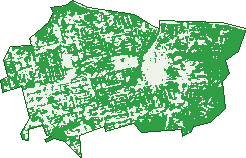
Green: 10 m cells where trees dominate, satellite 2021. Blue: water. The line is the suburb boundary.
| Canopy share, 1 m canopy height map, 2020 | 23.8% |
|---|---|
| Land with trees, 10 m satellite map, 2021 | 70.6% |
Demographics
Unemployment 5.4% · Labour-force participation 63.6%
Population by age in Epping
| 0-4 | 1,543 |
|---|---|
| 5-14 | 4,059 |
| 15-19 | 1,500 |
| 20-24 | 1,889 |
| 25-34 | 4,906 |
| 35-44 | 5,114 |
| 45-54 | 3,454 |
| 55-64 | 3,069 |
| 65-74 | 2,434 |
| 75-84 | 1,064 |
| 85+ | 529 |
Dwelling types in Epping
| House | 4,398 |
|---|---|
| Townhouse | 1,012 |
| Apartment | 4,904 |
| Other | 0 |
Households by weekly income in Epping
| <$650 | 1,151 |
|---|---|
| $650-1,499 | 1,985 |
| $1,500-2,999 | 3,227 |
| $3,000+ | 3,480 |
Top ancestries in Epping
| Chinese | 11,927 |
|---|---|
| Other | 3,936 |
| English | 3,635 |
| Australian | 3,141 |
| Korean | 2,926 |
| Indian | 2,848 |
Housing tenure in Epping
| Owned | 2,784 |
|---|---|
| Mortgage | 2,962 |
| Rented | 4,330 |
| Other | 152 |
Cars per household in Epping
| 0 | 1,099 |
|---|---|
| 1 | 4,986 |
| 2 | 3,128 |
| 3 | 716 |
| 4+ | 292 |
Commute to work in Epping
| Car | 3,564 |
|---|---|
| Train | 726 |
| Bus | 85 |
| Tram/ferry | 6 |
| Walked | 149 |
| Bicycle | 10 |
| Home | 7,570 |
Top countries of birth in Epping
| China | 5,833 |
|---|---|
| India | 2,797 |
| South Korea | 2,175 |
| Hong Kong | 1,598 |
| Malaysia | 501 |
| Philippines | 406 |
Languages used at home in Epping
| Mandarin | 6,829 |
|---|---|
| Cantonese | 3,583 |
| Korean | 2,749 |
| Hindi | 1,022 |
| Tamil | 556 |
| Urdu | 296 |
Birds & Wildlife Nearby
119,165 bird observations recorded near Epping — most often seen:
- Rainbow Lorikeet (10,540)
- Sulphur-crested Cockatoo (8,783)
- Noisy Miner (8,600)
- Laughing Kookaburra (6,868)
- Australian Magpie (6,447)
- Pied Currawong (4,985)
- Grey Butcherbird (4,948)
- Australian Raven (4,649)
- Australian King-parrot (3,687)
- Welcome Swallow (3,608)
- Australian Brush-turkey (3,559)
- Crimson Rosella (3,532)
- Eastern Yellow Robin (3,439)
Show all 30 birds recorded near Epping
- White-browed Scrubwren (3,335)
- Eastern Whipbird (3,279)
- Eastern Spinebill (3,234)
- Galah (3,080)
- Spotted Pardalote (2,813)
- Common Myna (2,773)
- Silvereye (2,702)
- Brown Thornbill (2,634)
- Brown Gerygone (2,571)
- Superb Fairy-wren (2,571)
- Yellow-faced Honeyeater (2,519)
- Red Wattlebird (2,449)
- Red-whiskered Bulbul (2,365)
- Eastern Rosella (2,350)
- Crested Pigeon (2,310)
- Tawny Frogmouth (2,296)
- Red-browed Finch (2,239)
Sightings reported by observers, not a survey, so the counts show what people record rather than what lives here. Source: Atlas of Living Australia.
Nearby Suburbs
The closest suburbs to Epping:
- Cheltenham (1.7 km)
- Eastwood (1.8 km)
- North Epping (2.1 km)
- Marsfield (2.6 km)
- Beecroft (2.8 km)
- Carlingford (2.9 km)
- Dundas Valley (3 km)
- Denistone West (3.1 km)
Embed this suburb
Add this free Epping stat card to your own site — just copy the code:
Preview:
Cite this page
Quoting these figures? Copy the credit line:
Keep an eye on Epping
One email when this data meaningfully changes — new census figures, prices, rankings. No spam, unsubscribe anytime.
Streets
- Abuklea Road (54)
- Albuera Road (34)
- Angus Avenue (58)
- Anthony Street (4)
- Arkena Avenue (26)
- Audine Avenue (23)
- Barombah Road (20)
- Bartil Close (8)
- Beecroft Road (106)
- Bimbadeen Street (24)
- Blaxland Road (101)
- Boronia Avenue (84)
- Brenda Way (6)
- Bridge Street (438)
- Brigadoon Court (12)
- Brigg Road (27)
- Broadway Circuit (34)
- Brucedale Avenue (38)
- Bulkira Road (24)
- Cambridge Street (988)
- Canberra Street (22)
- Carlingford Road (865)
- Chambers Court (304)
- Chelmsford Avenue (100)
- Chester Street (343)
- Chesterfield Road (94)
- Cliff Road (1,283)
- Cocos Avenue (1)
- Constance Close (15)
- Cooke Way (44)
- Cottee Drive (71)
- Crandon Road (151)
- Crown Street (26)
- Cumberland Street (36)
- Dallwood Avenue (33)
- Dalmar Place (1)
- Damon Avenue (20)
- Davis Avenue (13)
- Dawson Street (49)
- Delaware Street (36)
- Dengate Street (5)
- Dent Street (63)
- Derby Street (56)
- Donald Avenue (25)
- Dorset Street (106)
- Downing Street (74)
- Duignan Close (16)
- Duncan Place (9)
- Dunlop Street (135)
- Dunmore Road (34)
- Duntroon Avenue (26)
- Eastwood Avenue (29)
- Edenlee Street (56)
- Edensor Street (210)
- Elbon Avenue (20)
- Elgatta Place (6)
- Epping Avenue (34)
- Epping Park Drive (493)
- Epping Road (356)
- Essex Street (511)
- Eyles Avenue (26)
- Fernhill Avenue (46)
- Ferntree Place (626)
- First Avenue (26)
- Florence Place (10)
- Forest Grove (471)
- Francis Street (34)
- Garland Avenue (33)
- George Street (35)
- Glenfern Road (16)
- Gloucester Road (82)
- Grandview Parade (37)
- Grant Close (9)
- Grimes Lane (2)
- Hakea Place (7)
- Hamer Street (14)
- Haywood Street (32)
- Hazlewood Place (405)
- Helen Street (29)
- Hermington Street (48)
- High Street (44)
- Hillcrest Avenue (79)
- Hills Avenue (47)
- Hillside Crescent (53)
- Holden Avenue (19)
- Japonica Road (41)
- Kandy Avenue (119)
- Karonga Close (1)
- Kawana Close (28)
- Kent Street (512)
- Kerry Avenue (19)
- Knox Avenue (33)
- Langston Place (431)
- Leicester Street (28)
- Lewis Street (37)
- Lilli Pilli Street (22)
- Lomax Street (18)
- Magnolia Avenue (49)
- Maida Road (233)
- Mars Street (46)
- Mckechnie Street (14)
- Melrose Street (12)
- Meredith Street (8)
- Merinda Avenue (24)
- Midson Road (334)
- Mobbs Lane (46)
- Mountain Street (20)
- Muriel Avenue (19)
- Neil Street (36)
- Norfolk Road (106)
- Orchard Street (52)
- Ormonde Avenue (27)
- Oxford Street (822)
- Park Street (26)
- Patya Close (13)
- Pearl Avenue (23)
- Pembroke Street (332)
- Pennant Parade (164)
- Plympton Road (3)
- Rawson Street (370)
- Ray Road (560)
- Raymond Place (18)
- Reeves Avenue (7)
- Ridge Street (40)
- Rockleigh Way (27)
- Romford Road (32)
- Rose Street (11)
- Rosebank Avenue (20)
- Rosen Street (45)
- Ross Street (38)
- Ryde Street (82)
- Second Avenue (26)
- Seven Street (173)
- Shirley Street (22)
- Smith Street (151)
- Somerset Street (60)
- Stanley Road (107)
- Surrey Street (149)
- Sussex Street (26)
- Tarragundi Road (14)
- The Boulevarde (40)
- Third Avenue (95)
- Treeview Place (25)
- Valley Road (53)
- Victoria Street (337)
- Ward Street (18)
- Warrington Avenue (21)
- William Street (12)
- Willoughby Street (73)
- Willow Close (34)
- Windermere Road (28)
- Wingrove Avenue (53)
- Winifred Avenue (27)
- Wycombe Street (62)
- Wyralla Avenue (134)
- Wyvern Street (6)
- Yale Street (6)
- Yaraan Avenue (19)
- York Street (55)