Coleambally NSW 2707
1,277 addresses · 103 streets
Farrer Electorate › Murrumbidgee LGA › Coleambally · 497 km from Sydney
📦 Thinking of moving here? Read the Coleambally moving guide

Living Here
Coleambally is a suburb of New South Wales, home to about 1,152 people, with a median age of 43. The typical household earns around $1,555 a week, with median rent near $180 a week. Most homes are houses. About 66% of households own their home and 25% rent. Most workers drive to work. Common community backgrounds include Australian, English, Irish. On the ABS socio-economic scale it sits in decile 6 of 10 nationally — a mid-range area.
Over time — Census 2001 → 2021
Dashed line: district figures for the Griffith Region statistical area (SA2), the smallest area the ABS published before 2011. Solid line: Coleambally itself.
Getting Around & Local Services
1 golf club
1 hardware store
1 mechanic
1 electrician
Getting around. Airport: Narrandera Airport, 55.8 km east.
Socio-economic Standing
Deciles from 1 (lowest) to 10 (highest), against all Australian suburbs. The overall figure weighs advantage and disadvantage together; economic resources counts income and housing, and education & jobs counts qualifications and occupation. They often differ. Source: ABS SEIFA 2021.
Tree cover
🌳 Tree canopy: 1.5% share of land under canopy · satellite map, 2020
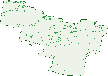
Green: 10 m cells where trees dominate, satellite 2021. Blue: water. The line is the suburb boundary.
| Canopy share, 1 m canopy height map, 2020 | 1.5% |
|---|---|
| Land with trees, 10 m satellite map, 2021 | 5.1% |
Demographics
Unemployment 1.7% · Labour-force participation 68.4%
Population by age in Coleambally
| 0-4 | 64 |
|---|---|
| 5-14 | 145 |
| 15-19 | 51 |
| 20-24 | 71 |
| 25-34 | 127 |
| 35-44 | 142 |
| 45-54 | 143 |
| 55-64 | 184 |
| 65-74 | 131 |
| 75-84 | 62 |
| 85+ | 40 |
Dwelling types in Coleambally
| House | 403 |
|---|---|
| Townhouse | 3 |
| Apartment | 21 |
| Other | 7 |
Households by weekly income in Coleambally
| <$650 | 50 |
|---|---|
| $650-1,499 | 145 |
| $1,500-2,999 | 161 |
| $3,000+ | 44 |
Top ancestries in Coleambally
| Australian | 540 |
|---|---|
| English | 470 |
| Irish | 162 |
| Scottish | 142 |
| Ancestry NS | 88 |
| Aboriginal | 43 |
Housing tenure in Coleambally
| Owned | 181 |
|---|---|
| Mortgage | 104 |
| Rented | 108 |
| Other | 37 |
Cars per household in Coleambally
| 0 | 14 |
|---|---|
| 1 | 122 |
| 2 | 156 |
| 3 | 70 |
| 4+ | 61 |
Commute to work in Coleambally
| Car | 355 |
|---|---|
| Train | 0 |
| Bus | 5 |
| Tram/ferry | 0 |
| Walked | 56 |
| Bicycle | 3 |
| Home | 129 |
Top countries of birth in Coleambally
| England | 10 |
|---|---|
| New Zealand | 9 |
| South Africa | 8 |
| India | 7 |
| Malaysia | 7 |
| Ireland | 4 |
Languages used at home in Coleambally
| Australian Indigenous | 5 |
|---|---|
| Punjabi | 4 |
| Afrikaans | 3 |
| Mandarin | 3 |
| German | 3 |
| Italian | 3 |
Birds & Wildlife Nearby
237 bird observations recorded near Coleambally — most often seen:
- Noisy Miner (24)
- Superb Parrot (17)
- Galah (14)
- Magpie-lark (14)
- Australian Magpie (13)
- Crested Pigeon (10)
- Nankeen Kestrel (9)
- Red-rumped Parrot (9)
- Apostlebird (8)
- Black-faced Cuckoo-shrike (8)
- Blue-faced Honeyeater (7)
- Great Egret (7)
- Willie Wagtail (7)
Show all 30 birds recorded near Coleambally
- Black-shouldered Kite (6)
- Eastern Australian Magpie (6)
- Eastern Galah (6)
- Grey Butcherbird (6)
- Pacific Black Duck (6)
- Pied Butcherbird (6)
- Spiny-cheeked Honeyeater (6)
- Black Kite (5)
- Brown Falcon (5)
- Chestnut-rumped Thornbill (5)
- Common Starling (5)
- Grey-crowned Babbler (5)
- Little Raven (5)
- South-eastern Grey Butcherbird (5)
- South-eastern Red-rumped Parrot (5)
- Australian Raven (4)
- Bluebonnet (4)
Sightings reported by observers, not a survey, so the counts show what people record rather than what lives here. Source: Atlas of Living Australia.
Nearby Suburbs
The closest suburbs to Coleambally:
- Gala Vale (18.6 km)
- Argoon (21.5 km)
- Darlington Point (29.4 km)
- Morundah (36.4 km)
- Mabins Well (37.1 km)
- Bundure (38.8 km)
- Euroley (40.6 km)
- Whitton (42 km)
Embed this suburb
Add this free Coleambally stat card to your own site — just copy the code:
Preview:
Cite this page
Quoting these figures? Copy the credit line:
Keep an eye on Coleambally
One email when this data meaningfully changes — new census figures, prices, rankings. No spam, unsubscribe anytime.
Streets
- Amaroo Avenue (10)
- Anderson Road (13)
- Argoon Road (7)
- Bellbird Street (44)
- Bencubbin Avenue (48)
- Bluebonnet Crescent (44)
- Boerema Road (8)
- Bonnars Lane (1)
- Boondilla Road (1)
- Bridge Road (4)
- Brolga Place (28)
- Bull Road (31)
- Burke Lane (5)
- Calrose Avenue (13)
- Canduro Road (1)
- Carnell Road (1)
- Carroll Road (2)
- Cattanach Road (2)
- Channel Nine Road (40)
- Citrus Drive (9)
- Clifford Downs Road (1)
- Cockys Lane (2)
- Commins Road (14)
- Corella Street (4)
- Crosby Road (3)
- Culley Road (14)
- Curlew Crescent (38)
- Currawong Crescent (50)
- De Sailly Road (10)
- Donald Ross Drive (23)
- Dornam Road (2)
- Durnan Road (3)
- Egan Road (12)
- Elaroo Lane (8)
- Ercildoune Road (5)
- Eulo Road (11)
- Fairlie Grange Road (13)
- Falcon Road (13)
- Field Road (8)
- Forge Road (5)
- Four Corners Road (8)
- Fraser Road (12)
- Gaston Road (22)
- Gilbert Road (54)
- Glenn Road (7)
- Graham Road (30)
- Hannabus Road (3)
- Hardys Road (4)
- Harveys Well Road (1)
- Hogans Lane (7)
- Hunter Road (9)
- Hutchings Road (15)
- Ibis Court (2)
- Jerilderie Road (9)
- Jimmy Cull Road (21)
- Kent Road (1)
- Kerslake Road (5)
- Kestrel Road (10)
- Kidman Way (30)
- Kingfisher Avenue (71)
- Kook Road (2)
- Kookaburra Avenue (60)
- Kyola Road (7)
- Leonard Road (5)
- Lloyd Road (5)
- Lovegrove Road (8)
- Lucas Road (2)
- Macleay Road (3)
- Main Canal Road (35)
- Manning Lane (3)
- Martin Bell Road (1)
- Mcdonald Road (21)
- Mcdougall Road (2)
- Mcgrath Road (3)
- Mclarty Road (9)
- Mellington Road (4)
- Mercer Road (1)
- Morley Road (4)
- Morundah Road (19)
- Muntz Lane (8)
- Old Morundah Road (4)
- Peet Road (3)
- Pike Lane (4)
- Pine Drive (14)
- Preston Road (3)
- Prickley Road (18)
- Pugsley Road (3)
- Robin Crescent (6)
- Rogart Road (1)
- Rosewood Road (13)
- Ryan Road (5)
- Sadleir Road (4)
- Sadlier Road (4)
- Sandpiper Street (45)
- Sheppard Lane (2)
- Steele Road (14)
- Sturt Highway (1)
- Thurrowa Road (10)
- Wallace Road (3)
- Wallin Road (9)
- Willaroo Street (24)
- Wood Road (11)
- Yamma Road (2)