Bungendore NSW 2621
2,607 addresses · 123 streets
Eden-Monaro Electorate › Queanbeyan-Palerang Regional LGA › Bungendore · 223 km from Sydney
📦 Thinking of moving here? Read the Bungendore moving guide

Living Here
Bungendore is a suburb of New South Wales, home to about 4,745 people, with a median age of 38. The typical household earns around $2,922 a week, with median rent near $510 a week. Most homes are houses. About 85% of households own their home and 14% rent. Most workers drive to work. Common community backgrounds include Australian, English, Irish. On the ABS socio-economic scale it sits in decile 10 of 10 nationally — a relatively advantaged area.
Over time — Census 2001 → 2021
Dashed line: district figures for the Queanbeyan Region statistical area (SA2), the smallest area the ABS published before 2011. Solid line: Bungendore itself.
Getting Around & Local Services
5 cafés & restaurants
1 supermarket
1 pharmacy
3 doctors & medical clinics
1 dentist
1 physiotherapist
1 vet
1 childcare centre
1 library
1 post office
1 service station
1 playground
1 bakery
1 butcher
1 hardware store
1 beauty salon
3 places to stay
Getting around. Train station: Bungendore, 250 m north · Airport: Canberra Airport, 23.5 km west.
Socio-economic Standing
Deciles from 1 (lowest) to 10 (highest), against all Australian suburbs. The overall figure weighs advantage and disadvantage together; economic resources counts income and housing, and education & jobs counts qualifications and occupation. They often differ. Source: ABS SEIFA 2021.
Tree cover
🌳 Tree canopy: 19.8% share of land under canopy · satellite map, 2020
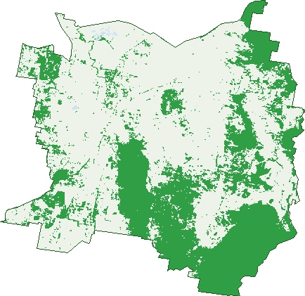
Green: 10 m cells where trees dominate, satellite 2021. Blue: water. The line is the suburb boundary.
| Canopy share, 1 m canopy height map, 2020 | 19.8% |
|---|---|
| Land with trees, 10 m satellite map, 2021 | 36.1% |
Demographics
Unemployment 2.3% · Labour-force participation 75.3%
Population by age in Bungendore
| 0-4 | 348 |
|---|---|
| 5-14 | 744 |
| 15-19 | 276 |
| 20-24 | 223 |
| 25-34 | 539 |
| 35-44 | 732 |
| 45-54 | 713 |
| 55-64 | 594 |
| 65-74 | 377 |
| 75-84 | 166 |
| 85+ | 38 |
Dwelling types in Bungendore
| House | 1,485 |
|---|---|
| Townhouse | 56 |
| Apartment | 21 |
| Other | 4 |
Households by weekly income in Bungendore
| <$650 | 86 |
|---|---|
| $650-1,499 | 211 |
| $1,500-2,999 | 459 |
| $3,000+ | 719 |
Top ancestries in Bungendore
| Australian | 2,095 |
|---|---|
| English | 2,070 |
| Irish | 629 |
| Scottish | 612 |
| Other | 306 |
| German | 279 |
Housing tenure in Bungendore
| Owned | 410 |
|---|---|
| Mortgage | 920 |
| Rented | 213 |
| Other | 17 |
Cars per household in Bungendore
| 0 | 16 |
|---|---|
| 1 | 310 |
| 2 | 716 |
| 3 | 302 |
| 4+ | 228 |
Commute to work in Bungendore
| Car | 1,895 |
|---|---|
| Train | 0 |
| Bus | 12 |
| Tram/ferry | 0 |
| Walked | 64 |
| Bicycle | 6 |
| Home | 362 |
Top countries of birth in Bungendore
| England | 226 |
|---|---|
| New Zealand | 68 |
| United States | 38 |
| Scotland | 27 |
| South Africa | 23 |
| Germany | 22 |
Languages used at home in Bungendore
| French | 20 |
|---|---|
| Italian | 16 |
| Afrikaans | 12 |
| German | 12 |
| Serbian | 11 |
| Greek | 8 |
Birds & Wildlife Nearby
47,735 bird observations recorded near Bungendore — most often seen:
- Australian Magpie (2,671)
- Crimson Rosella (2,487)
- Galah (2,482)
- Pacific Black Duck (2,399)
- Australian Raven (2,375)
- Sulphur-crested Cockatoo (2,360)
- Common Starling (2,174)
- Australian Wood Duck (2,110)
- Magpie-lark (1,984)
- Superb Fairy-wren (1,895)
- Australian Shelduck (1,865)
- Grey Teal (1,854)
- Welcome Swallow (1,803)
Show all 30 birds recorded near Bungendore
- Crested Pigeon (1,708)
- Yellow-rumped Thornbill (1,683)
- House Sparrow (1,628)
- Willie Wagtail (1,571)
- Red Wattlebird (1,398)
- Pied Currawong (1,293)
- Masked Lapwing (1,227)
- Eurasian Coot (1,029)
- Eastern Rosella (1,027)
- Silvereye (1,019)
- Nankeen Kestrel (923)
- Plumed Whistling-duck (831)
- Grey Shrike-thrush (809)
- Little Raven (807)
- Grey Fantail (778)
- White-faced Heron (777)
- Brown Thornbill (768)
Sightings reported by observers, not a survey, so the counts show what people record rather than what lives here. Source: Atlas of Living Australia.
Nearby Suburbs
The closest suburbs to Bungendore:
- Wamboin (11.1 km)
- Bywong (14 km)
- Lake George (14.1 km)
- Mulloon (15.4 km)
- Hoskinstown (16.3 km)
- Mount Fairy (16.9 km)
- Carwoola (17.1 km)
- The Ridgeway (19 km)
Embed this suburb
Add this free Bungendore stat card to your own site — just copy the code:
Preview:
Cite this page
Quoting these figures? Copy the credit line:
Keep an eye on Bungendore
One email when this data meaningfully changes — new census figures, prices, rankings. No spam, unsubscribe anytime.
Streets
- Aberfeldy Lane (4)
- Angus Place (19)
- Ashby Drive (41)
- Backrun Road (5)
- Bede Road (4)
- Birch Drive (30)
- Birchfield Drive (34)
- Bluskie Close (14)
- Briars Sharrow Road (4)
- Bridget Avenue (1)
- Brimble Close (6)
- Brooks Creek Road (7)
- Bunduluk Road (12)
- Bungendore Road (30)
- Burrows Lane (5)
- Butmaroo Road (28)
- Butmaroo Street (68)
- Carlton Drive (12)
- Carnell Close (5)
- Champion Lane (3)
- Charlotte Place (9)
- Cherry Tree Lane (6)
- Chinnery Close (10)
- Clare Lane (18)
- Cobb Court (17)
- Collingwood Close (9)
- Davis Close (9)
- Day Circuit (48)
- Deniston Circuit (20)
- Donoghoe Place (3)
- Duncan Avenue (8)
- Duralla Street (41)
- Ellen Street (55)
- Ellendon Street (144)
- Elmslea Drive (25)
- Essendon Road (9)
- Eyre Street (27)
- Falconer Place (15)
- Faunce Place (5)
- Finch Street (23)
- Flynn Place (10)
- Forster Street (98)
- Galloway Place (8)
- Galvins Creek Road (1)
- Gibraltar Street (132)
- Gidleigh Lane (38)
- Gordon Lane (1)
- Greenhill Lane (3)
- Halfway Creek Road (2)
- Harp Avenue (4)
- Harrowfield Drive (8)
- Hatch Lane (2)
- Hereford Street (42)
- Hillside Lane (4)
- Hope Drive (17)
- Hopkins Street (41)
- Hoskinstown Road (26)
- Hyland Drive (45)
- Ingledow Road (5)
- Ireland Place (8)
- Jacombs Street (13)
- Joe Rocks Road (13)
- John Dwyer Crescent (23)
- Keeffe Place (15)
- King Street (58)
- Kings Highway (49)
- Lake Road (9)
- Larmer Street (36)
- Leahy Place (6)
- Lithgow Place (11)
- Lundie Street (15)
- Mac's Reef Road (5)
- Majara Street (40)
- Malbon Street (96)
- Maslin Place (17)
- Masters Close (4)
- Mathews Lane (22)
- Mathews Place (8)
- Mcclung Drive (2)
- Mccusker Drive (45)
- Mcdonnell Drive (15)
- Mcfadzen Place (8)
- Mckay Drive (12)
- Mcmahon Drive (34)
- Mealla Way (7)
- Mecca Lane (29)
- Mill Post Lane (11)
- Millwood Lane (4)
- Modbury Street (45)
- Molonglo Street (67)
- Moses Street (13)
- Murray Grey Place (11)
- Neils Creek Road (15)
- Nelson Terrace (21)
- O'neill Place (7)
- Osborne Street (25)
- Powell Street (11)
- Range Road (3)
- Reardon Place (17)
- Ricketts Place (19)
- Rocky Glen Road (2)
- Rosella Place (15)
- Rutledge Street (49)
- Scott Street (15)
- Shanahan Street (10)
- Simms Drive (15)
- Sorrell Close (6)
- Sparrow Close (12)
- Spring Creek Road (13)
- Strathmore Place (8)
- Sugarloaf Road (21)
- Talbot Street (37)
- Tarago Road (30)
- The Mountain Road (11)
- Trucking Yard Lane (22)
- Turallo Terrace (50)
- Valley View Lane (1)
- Wardell Street (29)
- Westwood Circuit (27)
- Whitton Rise (25)
- Wild Terrace (10)
- Winter Road (4)
- Woolcara Lane (6)