Broken Hill NSW 2880
13,296 addresses · 197 streets
Parkes Electorate › Broken Hill LGA › Broken Hill · 934 km from Sydney
📦 Thinking of moving here? Read the Broken Hill moving guide

Living Here
A historic mining city in far-western New South Wales, Broken Hill is a remote outback centre with a strong heritage. Households average 2.2 people and the median age is 44. Median household income is $1,176 a week, and rent is very affordable at around $220.
Broken Hill is a suburb of New South Wales, home to about 17,706 people, with a median age of 44. The typical household earns around $1,176 a week, with median rent near $220 a week. Most homes are houses. About 74% of households own their home and 24% rent. Most workers drive to work. Common community backgrounds include Australian, English, Ancestry NS. On the ABS socio-economic scale it sits in decile 2 of 10 nationally — a more disadvantaged area.
Over time — Census 2001 → 2021
Dashed line: district figures for the Broken Hill statistical area (SA2), the smallest area the ABS published before 2011. Solid line: Broken Hill itself.
Getting Around & Local Services
3 supermarkets
1 Catholic church
1 medical clinic
3 optometrists
2 hospitals
1 childcare centre
1 library
3 gyms & sports centres
1 golf club
1 playground
2 bakeries
2 butchers
2 beauty salons
Getting around. Train station: Broken Hill, 700 m east · Airport: Broken Hill Airport, 5 km south.
Socio-economic Standing
Deciles from 1 (lowest) to 10 (highest), against all Australian suburbs. The overall figure weighs advantage and disadvantage together; economic resources counts income and housing, and education & jobs counts qualifications and occupation. They often differ. Source: ABS SEIFA 2021.
Tree cover
🌳 Tree canopy: 3.7% share of land under canopy · satellite map, 2020
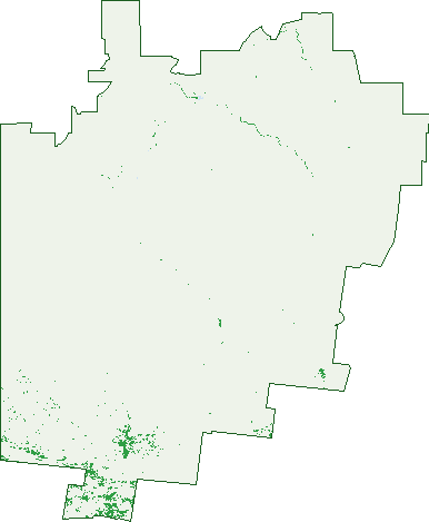
Green: 10 m cells where trees dominate, satellite 2021. Blue: water. The line is the suburb boundary.
| Canopy share, 1 m canopy height map, 2020 | 3.7% |
|---|---|
| Land with trees, 10 m satellite map, 2021 | 1.7% |
Demographics
Unemployment 5.5% · Labour-force participation 52.1%
Population by age in Broken Hill
| 0-4 | 974 |
|---|---|
| 5-14 | 2,040 |
| 15-19 | 976 |
| 20-24 | 898 |
| 25-34 | 2,187 |
| 35-44 | 1,901 |
| 45-54 | 2,030 |
| 55-64 | 2,586 |
| 65-74 | 2,238 |
| 75-84 | 1,281 |
| 85+ | 592 |
Dwelling types in Broken Hill
| House | 6,944 |
|---|---|
| Townhouse | 177 |
| Apartment | 186 |
| Other | 12 |
Households by weekly income in Broken Hill
| <$650 | 1,809 |
|---|---|
| $650-1,499 | 2,249 |
| $1,500-2,999 | 1,768 |
| $3,000+ | 900 |
Top ancestries in Broken Hill
| Australian | 7,647 |
|---|---|
| English | 6,692 |
| Ancestry NS | 1,642 |
| Aboriginal | 1,630 |
| Irish | 1,598 |
| Scottish | 1,509 |
Housing tenure in Broken Hill
| Owned | 3,101 |
|---|---|
| Mortgage | 2,202 |
| Rented | 1,739 |
| Other | 149 |
Cars per household in Broken Hill
| 0 | 700 |
|---|---|
| 1 | 3,076 |
| 2 | 2,379 |
| 3 | 721 |
| 4+ | 307 |
Commute to work in Broken Hill
| Car | 5,526 |
|---|---|
| Train | 0 |
| Bus | 8 |
| Tram/ferry | 0 |
| Walked | 276 |
| Bicycle | 28 |
| Home | 329 |
Top countries of birth in Broken Hill
| Philippines | 201 |
|---|---|
| England | 141 |
| New Zealand | 73 |
| India | 70 |
| Germany | 35 |
| United States | 27 |
Languages used at home in Broken Hill
| Filipino | 70 |
|---|---|
| Tagalog | 66 |
| Australian Indigenous | 52 |
| Italian | 52 |
| Malayalam | 32 |
| Arabic | 28 |
Birds & Wildlife Nearby
10,389 bird observations recorded near Broken Hill — most often seen:
- House Sparrow (2,093)
- Crested Pigeon (750)
- Little Corella (696)
- Australian Magpie (686)
- Little Crow (591)
- Rock Dove (525)
- White-plumed Honeyeater (508)
- Yellow-throated Miner (483)
- Spiny-cheeked Honeyeater (372)
- Magpie-lark (346)
- Galah (296)
- Black Kite (233)
- Eurasian Blackbird (231)
Show all 30 birds recorded near Broken Hill
- Welcome Swallow (227)
- Pied Butcherbird (223)
- Black-faced Cuckoo-shrike (196)
- Brown Goshawk (194)
- Mallee Ringneck (193)
- Australian Raven (161)
- Chirruping Wedgebill (156)
- Singing Honeyeater (155)
- Emu (142)
- White-breasted Woodswallow (137)
- Willie Wagtail (123)
- Eastern Crested Pigeon (121)
- Pacific Black Duck (120)
- Australasian Grebe (113)
- Central White-plumed Honeyeater (108)
- Australian Ringneck (107)
- Nankeen Kestrel (103)
Sightings reported by observers, not a survey, so the counts show what people record rather than what lives here. Source: Atlas of Living Australia.
Nearby Suburbs
The closest suburbs to Broken Hill:
- Silverton (26.6 km)
Embed this suburb
Add this free Broken Hill stat card to your own site — just copy the code:
Preview:
Cite this page
Quoting these figures? Copy the credit line:
Keep an eye on Broken Hill
One email when this data meaningfully changes — new census figures, prices, rankings. No spam, unsubscribe anytime.
Streets
- Airport Road (5)
- Albert Morris Avenue (44)
- Aleppo Place (4)
- Allendale Street (45)
- Argent Lane (17)
- Argent Street (519)
- Arizona Place (3)
- Athel Place (4)
- Bagot Street (32)
- Barrier Highway (41)
- Bathurst Street (20)
- Beryl Lane (11)
- Beryl Street (327)
- Bismuth Street (41)
- Blende Street (471)
- Block 10 Hill (5)
- Bonanza Street (47)
- Boron Street (4)
- Boughtman Street (152)
- Bowen Street (26)
- Braceman Street (33)
- Brady Street (6)
- Brazil Street (120)
- Bromide Street (148)
- Bronhill Street (4)
- Brookfield Avenue (73)
- Brooks Lane (1)
- Brooks Street (24)
- Brown Lane (1)
- Brown Street (85)
- Buck Street (87)
- Burke Street (74)
- Calcite Street (6)
- Callitris Place (3)
- Campbell Street (2)
- Carbon Street (26)
- Casuarina Avenue (16)
- Central Street (34)
- Chapple Lane (189)
- Chapple Street (339)
- Chettle Street (12)
- Chloride Street (178)
- Clarke Street (99)
- Cobalt Lane (2)
- Cobalt Street (191)
- Comstock Street (39)
- Cornish Lane (22)
- Cornish Street (153)
- Creedon Street (91)
- Crystal Lane (6)
- Crystal Street (125)
- Cummins Lane (158)
- Cummins Place (11)
- Cummins Street (283)
- Delamore Street (2)
- Doe Street (14)
- Duff Street (144)
- Dundas Avenue (12)
- Eyre Street (119)
- Finn Street (7)
- Fisher Street (102)
- Gaffney Lane (86)
- Gaffney Street (128)
- Galena Street (62)
- Garnet Street (92)
- Gawler Place (10)
- Gossan Street (97)
- Graphite Street (3)
- Griffith Street (2)
- Griffiths Street (1)
- Gypsum Street (129)
- Hall Street (36)
- Harris Street (55)
- Harvy Street (36)
- Haskard Street (11)
- Hebbard Street (197)
- Hill Street (40)
- Holten Drive (2)
- Horsington Drive (1)
- Horsington Street (14)
- Hynes Street (9)
- Iodide Lane (10)
- Iodide Street (183)
- Jabez Street (17)
- Jacaranda Place (4)
- Jamieson Street (165)
- Jones Street (43)
- Junction Circle (12)
- Kanandah Place (4)
- Kanandah Road (41)
- Kaolin Street (124)
- King Street (24)
- Knox Lane (8)
- Knox Street (159)
- Lambert Place (3)
- Lane Lane (183)
- Lane Street (303)
- Lawton Street (26)
- Loch Lilly Road (2)
- Long Street (40)
- Lunam Street (14)
- Magazine Way (4)
- Mann Street (6)
- Marks Street (28)
- May Harding Drive (3)
- Mcculloch Street (114)
- Mcgillivray Drive (2)
- Mcgowen Street (167)
- Menindee Road (18)
- Mercury Street (62)
- Mica Street (147)
- Morgan Lane (99)
- Morgan Street (242)
- Morish Street (195)
- Murton Street (58)
- Netley Road (5)
- Newton Lane (44)
- Newton Street (137)
- Nicholls Street (107)
- Nine Mile Road (5)
- Norfolk Avenue (13)
- North Mine Avenue (13)
- O'farrell Street (21)
- O'neill Street (57)
- Off Crystal Street (2)
- Old South Road (2)
- Oxide Street (302)
- Patton Lane (2)
- Patton Street (268)
- Pell Lane (61)
- Pell Street (96)
- Phillips Street (3)
- Picton Sale Yard Road (1)
- Picton Street (30)
- Pinnacles Place (26)
- Pinnacles Road (19)
- Piper Street (205)
- Pro Hart Way (5)
- Proprietary Square (15)
- Quarry Street (2)
- Queen Street (27)
- Racecourse Road (17)
- Radium Street (58)
- Railway Parade (12)
- Rainbow Avenue (36)
- Rakow Street (38)
- Range Road (4)
- Rasp Street (9)
- Rhodenite Street (7)
- Rockwell Street (27)
- Rowe Street (77)
- Ryan Lane (72)
- Ryan Street (186)
- Sampson Street (2)
- Schlapp Street (35)
- Silica Street (32)
- Silver City Highway (20)
- Silver Street (33)
- Silverton Road (1)
- Skipman Street (20)
- Slag Street (10)
- South Road (11)
- South Street (53)
- Sturt Street (8)
- Sulphide Street (121)
- Talbot Street (19)
- Talc Street (7)
- Tandou Road (2)
- Thomas Lane (112)
- Thomas Street (263)
- Tin Street (16)
- Torquata Place (3)
- Tramway Terrace (24)
- Tuart Street (21)
- Union Street (16)
- Uranium Street (29)
- Wandoo Street (52)
- Warnock Street (4)
- Warren Street (23)
- Wentworth Road (26)
- Westside Drive (16)
- Whittaker Street (9)
- Wickes Street (32)
- Williams Lane (194)
- Williams Street (461)
- Wills Lane (77)
- Wills Street (160)
- Willyama Street (19)
- Wilson Lane (1)
- Wilson Street (201)
- Wolfram Lane (44)
- Wolfram Street (297)
- Wright Street (33)
- Wyman Lane (80)
- Wyman Street (232)
- Zebina Street (83)
- Zinc Street (3)