Belmore NSW 2192
7,583 addresses · 93 streets
Watson Electorate › Canterbury-Bankstown LGA › Belmore · 12 km from Sydney
📦 Thinking of moving here? Read the Belmore moving guide

Living Here
Belmore is a suburb of New South Wales, home to about 13,781 people, with a median age of 38. The typical household earns around $1,456 a week, with median rent near $380 a week. Most homes are apartments. About 54% of households own their home and 44% rent. Most workers drive to work. Common community backgrounds include Greek, Lebanese, Chinese. On the ABS socio-economic scale it sits in decile 4 of 10 nationally — a mid-range area.
Over time — Census 2001 → 2021
Dashed line: district figures for the Belmore - Belfield statistical area (SA2), the smallest area the ABS published before 2011. Solid line: Belmore itself.
Getting Around & Local Services
Getting around. Train station: Kingsgrove, 2.6 km south-east · Metro station: Belmore, 200 m north · Light rail stop: Dulwich Hill, 4.8 km east · Bus interchange: Bankstown Station, 5 km west · Airport: Bankstown Airport, 8.8 km west.
Socio-economic Standing
Deciles from 1 (lowest) to 10 (highest), against all Australian suburbs. The overall figure weighs advantage and disadvantage together; economic resources counts income and housing, and education & jobs counts qualifications and occupation. They often differ. Source: ABS SEIFA 2021.
Tree cover
🌳 Tree canopy: 8.1% share of land under canopy · satellite map, 2020
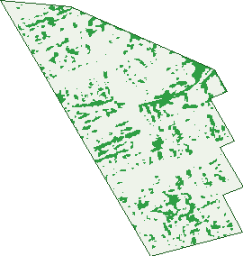
Green: 10 m cells where trees dominate, satellite 2021. Blue: water. The line is the suburb boundary.
| Canopy share, 1 m canopy height map, 2020 | 8.1% |
|---|---|
| Surveyed canopy, Greater Sydney aerial survey, 2019 | 9.2% |
| Land with trees, 10 m satellite map, 2021 | 8.4% |
Demographics
Unemployment 7.3% · Labour-force participation 48.1%
Population by age in Belmore
| 0-4 | 781 |
|---|---|
| 5-14 | 1,434 |
| 15-19 | 720 |
| 20-24 | 976 |
| 25-34 | 2,210 |
| 35-44 | 1,902 |
| 45-54 | 1,811 |
| 55-64 | 1,630 |
| 65-74 | 1,182 |
| 75-84 | 789 |
| 85+ | 348 |
Dwelling types in Belmore
| House | 2,085 |
|---|---|
| Townhouse | 453 |
| Apartment | 2,195 |
| Other | 16 |
Households by weekly income in Belmore
| <$650 | 917 |
|---|---|
| $650-1,499 | 1,394 |
| $1,500-2,999 | 1,399 |
| $3,000+ | 772 |
Top ancestries in Belmore
| Other | 3,600 |
|---|---|
| Greek | 1,979 |
| Lebanese | 1,559 |
| Chinese | 1,440 |
| Ancestry NS | 1,398 |
| Australian | 1,365 |
Housing tenure in Belmore
| Owned | 1,262 |
|---|---|
| Mortgage | 1,259 |
| Rented | 2,049 |
| Other | 87 |
Cars per household in Belmore
| 0 | 670 |
|---|---|
| 1 | 2,136 |
| 2 | 1,265 |
| 3 | 379 |
| 4+ | 207 |
Commute to work in Belmore
| Car | 1,916 |
|---|---|
| Train | 224 |
| Bus | 31 |
| Tram/ferry | 0 |
| Walked | 106 |
| Bicycle | 12 |
| Home | 1,610 |
Top countries of birth in Belmore
| Greece | 808 |
|---|---|
| China | 751 |
| Lebanon | 603 |
| Vietnam | 493 |
| South Korea | 318 |
| Philippines | 292 |
Languages used at home in Belmore
| Greek | 1,709 |
|---|---|
| Arabic | 1,614 |
| Mandarin | 692 |
| Vietnamese | 636 |
| Cantonese | 461 |
| Korean | 393 |
Birds & Wildlife Nearby
110,689 bird observations recorded near Belmore — most often seen:
- Rainbow Lorikeet (8,997)
- Australian White Ibis (7,483)
- Noisy Miner (6,516)
- Common Myna (6,359)
- Australian Magpie (5,505)
- Australian Raven (5,260)
- Spotted Turtle-dove (4,943)
- Pied Currawong (4,903)
- Rock Dove (4,702)
- Magpie-lark (4,006)
- Red-whiskered Bulbul (3,822)
- Welcome Swallow (3,811)
- Sulphur-crested Cockatoo (3,799)
Show all 30 birds recorded near Belmore
- Dusky Moorhen (3,002)
- Common Starling (2,984)
- Silvereye (2,887)
- Superb Fairy-wren (2,802)
- Willie Wagtail (2,780)
- Grey Butcherbird (2,772)
- Red Wattlebird (2,467)
- Crested Pigeon (2,412)
- Pacific Black Duck (2,338)
- Laughing Kookaburra (2,296)
- New Holland Honeyeater (2,264)
- Eastern Pied Currawong (2,200)
- Chestnut Teal (2,129)
- Eastern Rainbow Lorikeet (1,993)
- White-faced Heron (1,783)
- Eastern Red Wattlebird (1,746)
- Little Black Cormorant (1,728)
Sightings reported by observers, not a survey, so the counts show what people record rather than what lives here. Source: Atlas of Living Australia.
Nearby Suburbs
The closest suburbs to Belmore:
- Lakemba (1.2 km)
- Campsie (1.4 km)
- Clemton Park (1.6 km)
- Belfield (1.6 km)
- Roselands (1.9 km)
- Wiley Park (2 km)
- Kingsgrove (2.5 km)
- Canterbury (2.5 km)
Embed this suburb
Add this free Belmore stat card to your own site — just copy the code:
Preview:
Cite this page
Quoting these figures? Copy the credit line:
Keep an eye on Belmore
One email when this data meaningfully changes — new census figures, prices, rankings. No spam, unsubscribe anytime.
Streets
- Acacia Street (30)
- Adelaide Street (36)
- Albert Street (51)
- Allan Avenue (106)
- Allegra Avenue (29)
- Anderson Street (149)
- Archibald Street (30)
- Belmore Avenue (65)
- Benaroon Road (36)
- Benda Street (18)
- Brande Street (33)
- Bridge Road (104)
- Burwood Road (1,034)
- Canterbury Road (695)
- Cecilia Street (64)
- Chalmers Street (107)
- Chapel Street (99)
- Chelmsford Avenue (86)
- Cleary Avenue (64)
- Cobden Street (31)
- Collins Street (61)
- Dennis Street (1)
- Dinora Street (15)
- Drummond Street (209)
- Edison Lane (4)
- Edison Street (30)
- Eleanor Avenue (37)
- Etela Street (157)
- Eulda Street (20)
- Forbes Avenue (10)
- Forsyth Street (36)
- Garden Street (97)
- Gladstone Street (55)
- Hall Street (33)
- Harp Street (55)
- Hugh Street (113)
- Isabel Street (54)
- Kennedy Avenue (65)
- Kent Street (93)
- Kingsgrove Road (128)
- Knox Street (262)
- Lakemba Street (158)
- Lark Street (10)
- Leylands Parade (301)
- Liberty Street (100)
- Lucerne Street (248)
- Marie Street (2)
- Marlene Place (15)
- Minnie Street (33)
- Moncur Avenue (28)
- Myall Street (12)
- Neale Street (9)
- Nelson Avenue (107)
- Norma Avenue (23)
- Oxford Street (52)
- Palmer Street (2)
- Paragon Lane (17)
- Passey Avenue (35)
- Paxton Avenue (66)
- Pearl Avenue (15)
- Peel Street (68)
- Pelman Avenue (16)
- Penrose Avenue (31)
- Pithers Street (11)
- Platts Avenue (124)
- Plimsoll Street (38)
- Price Street (6)
- Punchbowl Road (4)
- Railway Parade (10)
- Redman Parade (50)
- Rees Avenue (24)
- Reginald Avenue (49)
- Ring Street (14)
- Robert Street (36)
- Rod Street (2)
- Rydge Street (26)
- Sharp Street (133)
- St Clair Street (141)
- St Jude Crescent (54)
- Station Road (5)
- Sudbury Street (168)
- The Boulevarde (4)
- Trafalgar Street (147)
- Tudor Street (52)
- Turton Avenue (17)
- Victory Street (47)
- Walker Street (2)
- Waverley Street (144)
- Westwood Avenue (17)
- Wilson Avenue (58)
- Wortley Avenue (11)
- Yangoora Road (281)
- York Street (158)