Bass Hill NSW 2197
4,213 addresses · 82 streets
Blaxland Electorate › Canterbury-Bankstown LGA › Bass Hill · 20 km from Sydney
📦 Thinking of moving here? Read the Bass Hill moving guide

Living Here
Bass Hill is a suburb of New South Wales, home to about 10,230 people, with a median age of 34. The typical household earns around $1,411 a week, with median rent near $450 a week. Most homes are houses. About 65% of households own their home and 34% rent. Most workers drive to work. Common community backgrounds include Lebanese, Australian, Ancestry NS. On the ABS socio-economic scale it sits in decile 3 of 10 nationally — a more disadvantaged area.
Over time — Census 2001 → 2021
Dashed line: district figures for the Bass Hill - Georges Hall statistical area (SA2), the smallest area the ABS published before 2011. Solid line: Bass Hill itself.
Getting Around & Local Services
2 vets
1 childcare centre
2 playgrounds
2 dog parks
3 butchers
3 beauty salons
1 plumber
2 carpenters
Getting around. Train station: Chester Hill, 1.7 km north · Metro station: Bankstown, 4.1 km south-east · Bus interchange: Bankstown Station, 4.1 km south-east · Airport: Bankstown Airport, 3 km south.
Socio-economic Standing
Deciles from 1 (lowest) to 10 (highest), against all Australian suburbs. The overall figure weighs advantage and disadvantage together; economic resources counts income and housing, and education & jobs counts qualifications and occupation. They often differ. Source: ABS SEIFA 2021.
Tree cover
🌳 Tree canopy: 13.9% share of land under canopy · satellite map, 2020
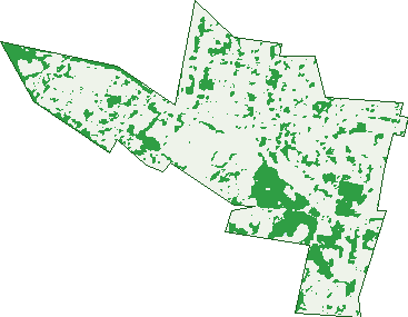
Green: 10 m cells where trees dominate, satellite 2021. Blue: water. The line is the suburb boundary.
| Canopy share, 1 m canopy height map, 2020 | 13.9% |
|---|---|
| Surveyed canopy, Greater Sydney aerial survey, 2019 | 12.6% |
| Land with trees, 10 m satellite map, 2021 | 18.9% |
Demographics
Unemployment 8.7% · Labour-force participation 41.9%
Population by age in Bass Hill
| 0-4 | 771 |
|---|---|
| 5-14 | 1,661 |
| 15-19 | 729 |
| 20-24 | 679 |
| 25-34 | 1,316 |
| 35-44 | 1,271 |
| 45-54 | 1,165 |
| 55-64 | 1,112 |
| 65-74 | 816 |
| 75-84 | 491 |
| 85+ | 239 |
Dwelling types in Bass Hill
| House | 2,010 |
|---|---|
| Townhouse | 564 |
| Apartment | 202 |
| Other | 8 |
Households by weekly income in Bass Hill
| <$650 | 527 |
|---|---|
| $650-1,499 | 839 |
| $1,500-2,999 | 749 |
| $3,000+ | 480 |
Top ancestries in Bass Hill
| Lebanese | 2,488 |
|---|---|
| Other | 2,267 |
| Australian | 1,645 |
| Ancestry NS | 1,236 |
| English | 1,199 |
| Vietnamese | 1,004 |
Housing tenure in Bass Hill
| Owned | 839 |
|---|---|
| Mortgage | 917 |
| Rented | 921 |
| Other | 44 |
Cars per household in Bass Hill
| 0 | 200 |
|---|---|
| 1 | 862 |
| 2 | 1,019 |
| 3 | 395 |
| 4+ | 246 |
Commute to work in Bass Hill
| Car | 1,392 |
|---|---|
| Train | 33 |
| Bus | 19 |
| Tram/ferry | 0 |
| Walked | 35 |
| Bicycle | 0 |
| Home | 864 |
Top countries of birth in Bass Hill
| Lebanon | 915 |
|---|---|
| Vietnam | 813 |
| Iraq | 126 |
| Italy | 115 |
| China | 98 |
| Greece | 85 |
Languages used at home in Bass Hill
| Arabic | 3,125 |
|---|---|
| Vietnamese | 1,035 |
| Greek | 211 |
| Cantonese | 162 |
| Italian | 154 |
| Macedonian | 117 |
Birds & Wildlife Nearby
30,765 bird observations recorded near Bass Hill — most often seen:
- Australian White Ibis (3,332)
- Rainbow Lorikeet (2,666)
- Noisy Miner (1,942)
- Australian Magpie (1,900)
- Australian Raven (1,548)
- Common Myna (1,517)
- Sulphur-crested Cockatoo (1,196)
- Magpie-lark (1,175)
- Dusky Moorhen (993)
- Pied Currawong (958)
- Superb Fairy-wren (955)
- Rock Dove (948)
- Crested Pigeon (912)
Show all 30 birds recorded near Bass Hill
- Australian Wood Duck (897)
- Pacific Black Duck (892)
- Willie Wagtail (855)
- Welcome Swallow (771)
- Red Wattlebird (756)
- Spotted Turtle-dove (721)
- Galah (658)
- Laughing Kookaburra (641)
- Red-whiskered Bulbul (631)
- Common Starling (584)
- Eurasian Coot (540)
- Grey Butcherbird (512)
- Australasian Purple Swamphen (507)
- Red-browed Finch (459)
- Masked Lapwing (437)
- Silvereye (432)
- Bell Miner (430)
Sightings reported by observers, not a survey, so the counts show what people record rather than what lives here. Source: Atlas of Living Australia.
Nearby Suburbs
The closest suburbs to Bass Hill:
- Georges Hall (1.4 km)
- Sefton (1.8 km)
- Villawood (2.1 km)
- Chester Hill (2.1 km)
- Lansdowne (2.3 km)
- Yagoona (2.4 km)
- Birrong (2.4 km)
- Bankstown Aerodrome (2.5 km)
Embed this suburb
Add this free Bass Hill stat card to your own site — just copy the code:
Preview:
Cite this page
Quoting these figures? Copy the credit line:
Keep an eye on Bass Hill
One email when this data meaningfully changes — new census figures, prices, rankings. No spam, unsubscribe anytime.
Streets
- Adeline Street (79)
- Amarina Avenue (7)
- Amber Place (15)
- Arundle Road (19)
- Australia Street (110)
- Avonlea Crescent (10)
- Baden Avenue (11)
- Baird Street (19)
- Bateman Crescent (4)
- Baxter Road (73)
- Beatrice Street (137)
- Beechwood Place (14)
- Belinda Street (4)
- Bennett Street (22)
- Brady Way (23)
- Broad Street (42)
- Brooke Street (14)
- Buist Street (104)
- Cameron Avenue (9)
- Cann Street (196)
- Carey Street (48)
- Carysfield Road (33)
- Cassia Place (14)
- Cherie Place (11)
- Chester Hill Road (221)
- Clarke Street (85)
- Compton Street (25)
- Cope Place (5)
- Coraki Road (17)
- Crucie Avenue (49)
- Dawson Place (9)
- Dooley Avenue (26)
- Doust Street (46)
- Eric Avenue (15)
- Farrell Road (83)
- Georgina Street (33)
- Greater Circuit (41)
- Handle Street (27)
- Hector Street (200)
- Henville Place (8)
- Hilda Street (19)
- Hitter Avenue (23)
- Hogan Avenue (3)
- Hume Highway (304)
- Iona Place (21)
- Janet Street (3)
- Jennings Avenue (12)
- Johnston Road (212)
- Kawana Street (119)
- Keegan Road (6)
- Kirrily Place (11)
- Kyogle Road (18)
- Leighdon Street (36)
- Leslie Street (5)
- Linda Avenue (23)
- Lucinda Avenue (75)
- Manuka Crescent (29)
- Marks Lane (1)
- Marks Street (1)
- Mcclean Street (1)
- Merle Street (68)
- Miller Road (129)
- Miriam Street (17)
- Neville Street (8)
- Newman Street (23)
- Orchard Road (190)
- Powers Place (10)
- Quentin Street (45)
- Rixon Street (41)
- Robertson Road (289)
- Sevenoaks Crescent (37)
- Strickland Street (144)
- Sussman Avenue (9)
- Thornton Avenue (70)
- Trebartha Street (162)
- Tucker Street (23)
- Union Street (31)
- Walther Avenue (9)
- Willow Place (12)
- Winston Avenue (17)
- Wynyard Avenue (30)
- Yvonne Crescent (19)