Ballina NSW 2478
9,107 addresses · 182 streets
Richmond Electorate › Ballina LGA › Ballina · 600 km from Sydney
📦 Thinking of moving here? Read the Ballina moving guide

Living Here
A coastal town on the NSW northern rivers near Byron Bay, Ballina is a popular retirement and holiday spot with an older profile (median age 56). Households average 2.0 people. Median household income is $1,013 a week, with rent around $360.
Ballina is a suburb of New South Wales, home to about 9,735 people, with a median age of 56. The typical household earns around $1,013 a week, with median rent near $360 a week. Most homes are houses. About 55% of households own their home and 38% rent. Most workers drive to work. Common community backgrounds include English, Australian, Irish. On the ABS socio-economic scale it sits in decile 3 of 10 nationally — a more disadvantaged area.
Over time — Census 2001 → 2021
Dashed line: district figures for the Ballina statistical area (SA2), the smallest area the ABS published before 2011. Solid line: Ballina itself.
Getting Around & Local Services
7 supermarkets
1 Catholic church
1 pharmacy
3 doctors & medical clinics
1 hospital
1 childcare centre
1 library
1 post office
5 service stations
2 golf clubs
2 playgrounds
1 butcher
2 hardware stores
1 hairdresser
1 beauty salon
1 mechanic
1 electrician
Getting around. Bus interchange: Byron Byron Gateway Airport Tour Operators, 2.5 km north · Ferry wharf: Burns Point Ferry, 3.6 km south-west · Airport: Ballina Byron Gateway Airport, 2.7 km north.
Socio-economic Standing
Deciles from 1 (lowest) to 10 (highest), against all Australian suburbs. The overall figure weighs advantage and disadvantage together; economic resources counts income and housing, and education & jobs counts qualifications and occupation. They often differ. Source: ABS SEIFA 2021.
Tree cover
🌳 Tree canopy: 42.9% share of land under canopy · satellite map, 2020
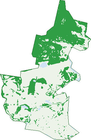
Green: 10 m cells where trees dominate, satellite 2021. Blue: water. The line is the suburb boundary.
| Canopy share, 1 m canopy height map, 2020 | 42.9% |
|---|---|
| Land with trees, 10 m satellite map, 2021 | 38.4% |
Demographics
Unemployment 3.9% · Labour-force participation 42.8%
Population by age in Ballina
| 0-4 | 376 |
|---|---|
| 5-14 | 780 |
| 15-19 | 372 |
| 20-24 | 377 |
| 25-34 | 881 |
| 35-44 | 932 |
| 45-54 | 1,004 |
| 55-64 | 1,266 |
| 65-74 | 1,578 |
| 75-84 | 1,265 |
| 85+ | 900 |
Dwelling types in Ballina
| House | 2,293 |
|---|---|
| Townhouse | 1,429 |
| Apartment | 433 |
| Other | 154 |
Households by weekly income in Ballina
| <$650 | 1,209 |
|---|---|
| $650-1,499 | 1,510 |
| $1,500-2,999 | 994 |
| $3,000+ | 328 |
Top ancestries in Ballina
| English | 4,173 |
|---|---|
| Australian | 3,721 |
| Irish | 1,284 |
| Scottish | 1,122 |
| Ancestry NS | 784 |
| Other | 591 |
Housing tenure in Ballina
| Owned | 1,551 |
|---|---|
| Mortgage | 768 |
| Rented | 1,613 |
| Other | 321 |
Cars per household in Ballina
| 0 | 509 |
|---|---|
| 1 | 2,112 |
| 2 | 1,216 |
| 3 | 310 |
| 4+ | 120 |
Commute to work in Ballina
| Car | 2,252 |
|---|---|
| Train | 0 |
| Bus | 11 |
| Tram/ferry | 0 |
| Walked | 190 |
| Bicycle | 103 |
| Home | 365 |
Top countries of birth in Ballina
| England | 352 |
|---|---|
| New Zealand | 170 |
| India | 96 |
| Philippines | 65 |
| South Africa | 40 |
| United States | 40 |
Languages used at home in Ballina
| Punjabi | 74 |
|---|---|
| Thai | 39 |
| Italian | 29 |
| Australian Indigenous | 26 |
| Spanish | 26 |
| Mandarin | 25 |
Birds & Wildlife Nearby
93,186 bird observations recorded near Ballina — most often seen:
- Crested Tern (5,420)
- Silver Gull (4,275)
- Rainbow Lorikeet (4,238)
- Australian White Ibis (4,205)
- Pied Cormorant (3,920)
- Torresian Crow (3,789)
- Noisy Miner (3,775)
- Welcome Swallow (3,733)
- Lewin's Honeyeater (3,476)
- Red-necked Stint (3,254)
- Little Black Cormorant (3,238)
- Willie Wagtail (3,158)
- Australasian Figbird (3,112)
Show all 30 birds recorded near Ballina
- Pied Currawong (3,076)
- Australian Pied Oystercatcher (3,047)
- Little Tern (2,945)
- Ruddy Turnstone (2,927)
- Australian Pelican (2,854)
- White-faced Heron (2,799)
- Pied Butcherbird (2,785)
- Pacific Black Duck (2,699)
- Little Pied Cormorant (2,569)
- Magpie-lark (2,553)
- Bar-shouldered Dove (2,458)
- Superb Fairy-wren (2,382)
- Eastern Whipbird (2,258)
- Australian Magpie (2,223)
- Great Egret (2,033)
- Little Wattlebird (2,019)
- Brown Honeyeater (1,966)
Sightings reported by observers, not a survey, so the counts show what people record rather than what lives here. Source: Atlas of Living Australia.
Nearby Suburbs
The closest suburbs to Ballina:
- East Ballina (2.6 km)
- West Ballina (2.7 km)
- South Ballina (2.8 km)
- Keith Hall (4.1 km)
- Cumbalum (4.9 km)
- Skennars Head (5.1 km)
- Lennox Head (7.2 km)
- Pimlico (8 km)
Embed this suburb
Add this free Ballina stat card to your own site — just copy the code:
Preview:
Cite this page
Quoting these figures? Copy the credit line:
Keep an eye on Ballina
One email when this data meaningfully changes — new census figures, prices, rankings. No spam, unsubscribe anytime.
Streets
- Abalone Place (15)
- Acacia Place (10)
- Albatross Street (13)
- Ascot Drive (8)
- Ascot Road (34)
- Bagot Place (6)
- Bagot Street (35)
- Bangalow Road (53)
- Bantry Street (36)
- Bentinck Street (172)
- Bernard Street (18)
- Biala Place (12)
- Boeing Avenue (21)
- Bolding Street (36)
- Bond Lane (17)
- Bonito Place (26)
- Borton Street (25)
- Broadbents Lane (2)
- Brunswick Street (32)
- Buchanan Street (24)
- Burnet Lane (1)
- Burnet Street (280)
- Camburt Street (13)
- Camden Lane (3)
- Camden Street (36)
- Camoola Avenue (28)
- Canal Road (65)
- Cargelligo Crescent (30)
- Carnation Court (19)
- Carrington Lane (6)
- Carrington Street (21)
- Cassia Circuit (24)
- Catherine Crescent (119)
- Cawarra Street (24)
- Cessna Crescent (55)
- Cherry Street (479)
- Christine Place (24)
- Church Lane (1)
- Clarence Street (9)
- Clark Street (167)
- Clavan Court (8)
- Clavan Street (72)
- Convair Avenue (10)
- Corks Lane (8)
- Crane Street (251)
- Crowley Avenue (16)
- Crowley Drive (4)
- Daisy Lane (3)
- Day Lane (5)
- De-havilland Crescent (117)
- Diamond Lane (2)
- Eagle Avenue (16)
- Edgewater Cove (26)
- Eider Quadrant (30)
- Elkhorn Parade (32)
- Elle Place (7)
- Endeavour Close (35)
- Fawcett Street (111)
- Ferngrove Drive (1)
- Fishery Creek Road (8)
- Fishery Lane (1)
- Florence Price Place (82)
- Foambank Circle (30)
- Foambark Circle (32)
- Forest Oak Boulevard (27)
- Fox Lane (21)
- Fox Street (216)
- Frangipani Circuit (20)
- Fripp Lane (5)
- Gallans Road (9)
- Gardenia Street (19)
- George Place (17)
- Grant Street (93)
- Greenhalgh Street (22)
- Hackett Lane (121)
- Hamilton Lane (6)
- Hamilton Street (41)
- Harrier Street (20)
- Helen Court (25)
- Henry Philp Avenue (29)
- Hercules Crescent (11)
- Hibiscus Avenue (15)
- Hickey Place (10)
- Hickey Street (29)
- Hogan Street (13)
- Holden Lane (15)
- Honey Myrtle Street (16)
- Hovea Drive (8)
- Ironbark Road (53)
- James Street (8)
- Jamie Place (16)
- Jarrett Lane (5)
- Jarrett Street (65)
- Kerr Street (188)
- Kestrel Street (18)
- Killala Avenue (6)
- King Lane (9)
- King Street (7)
- Kingsford Smith Drive (1)
- Kite Avenue (26)
- Knight Lane (5)
- Koda Avenue (7)
- Kookaburra Street (17)
- Latta Avenue (24)
- Laurel Lane (1)
- Lavender Boulevard (62)
- Leeson Avenue (28)
- Magnolia Drive (22)
- Maine Place (24)
- Manulla Street (10)
- Marine Street (23)
- Marsh Avenue (16)
- Marshall Street (43)
- Martin Street (285)
- Mary Street (2)
- Moon Street (136)
- Mulloway Place (13)
- Namitjira Place (88)
- Norlyn Avenue (38)
- North Creek Road (460)
- Norton Street (163)
- Oakwood Drive (43)
- Oasis Drive (14)
- Owen Street (105)
- Patchs Beach Road (3)
- Periwinkle Place (24)
- Piper Drive (115)
- Pipi Place (22)
- Poinsettia Street (9)
- Pool Lane (2)
- Primrose Circuit (35)
- Princess Avenue (13)
- Prosper Place (11)
- Protea Circuit (18)
- Racecourse Road (38)
- Ray O'neill Crescent (44)
- Redford Place (9)
- Regatta Avenue (8)
- Richmond Avenue (29)
- River Street (625)
- Ross Lane (5)
- Ross Street (76)
- Russell Street (26)
- Sandpiper Court (23)
- Seahorse Place (19)
- Sheather Street (35)
- Simmons Street (25)
- Skinner Street (101)
- Solander Court (6)
- Southern Cross Drive (317)
- St Andrews Place (2)
- St Francis Place (48)
- St Johns Close (16)
- St Marks Close (23)
- St Pauls Close (29)
- Stinson Street (25)
- Sunbird Avenue (32)
- Sunway Place (10)
- Swallowtail Place (17)
- Sweetlip Place (14)
- Swift Lane (4)
- Swift Street (344)
- Tamar (1)
- Tamar Street (565)
- Tamarind Drive (123)
- Teal Street (37)
- Temple Street (85)
- Teraglin Place (26)
- Tipperary Place (12)
- Torrens Lane (4)
- Treelands Crescent (58)
- Trevally Place (15)
- Tweed Street (12)
- Vera Place (16)
- Vera Street (66)
- Wayside Place (10)
- Webster Lane (11)
- Wejuba Gardens (13)
- Whiting Way (6)
- Winton Lane (80)
- Wisteria Street (17)
- Yellowood Drive (3)