Balgownie NSW 2519
2,703 addresses · 72 streets
Cunningham Electorate › Wollongong LGA › Balgownie · 65 km from Sydney
📦 Thinking of moving here? Read the Balgownie moving guide

Living Here
Balgownie is a suburb of New South Wales, home to about 5,722 people, with a median age of 42. The typical household earns around $1,912 a week, with median rent near $450 a week. Most homes are houses. About 77% of households own their home and 22% rent. Most workers drive to work. Common community backgrounds include English, Australian, Italian. On the ABS socio-economic scale it sits in decile 8 of 10 nationally — a relatively advantaged area.
Over time — Census 2001 → 2021
Dashed line: district figures for the Balgownie - Fairy Meadow statistical area (SA2), the smallest area the ABS published before 2011. Solid line: Balgownie itself.
Getting Around & Local Services
5 supermarkets
2 beaches
1 pharmacy
2 doctors & medical clinics
1 dentist
1 childcare centre
2 golf clubs
1 playground
1 bakery
1 butcher
1 hardware store
1 hairdresser
1 mechanic
1 electrician
1 plumber
Getting around. Train station: Fairy Meadow, 2 km south-east · Railway halt: Lysaghts, 7.4 km south · Bus interchange: Station St opp Wollongong Station, 4.5 km south · Airport: Shellharbour Airport, 20.7 km south-west.
Socio-economic Standing
Deciles from 1 (lowest) to 10 (highest), against all Australian suburbs. The overall figure weighs advantage and disadvantage together; economic resources counts income and housing, and education & jobs counts qualifications and occupation. They often differ. Source: ABS SEIFA 2021.
Tree cover
🌳 Tree canopy: 45.3% share of land under canopy · satellite map, 2020
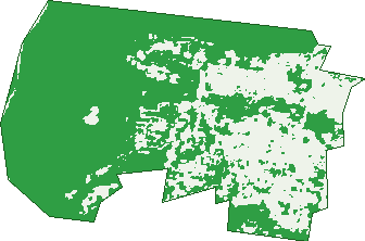
Green: 10 m cells where trees dominate, satellite 2021. Blue: water. The line is the suburb boundary.
| Canopy share, 1 m canopy height map, 2020 | 45.3% |
|---|---|
| Land with trees, 10 m satellite map, 2021 | 69.4% |
Demographics
Unemployment 3.5% · Labour-force participation 58.5%
Population by age in Balgownie
| 0-4 | 332 |
|---|---|
| 5-14 | 719 |
| 15-19 | 302 |
| 20-24 | 331 |
| 25-34 | 597 |
| 35-44 | 727 |
| 45-54 | 727 |
| 55-64 | 748 |
| 65-74 | 640 |
| 75-84 | 461 |
| 85+ | 128 |
Dwelling types in Balgownie
| House | 1,531 |
|---|---|
| Townhouse | 557 |
| Apartment | 35 |
| Other | 12 |
Households by weekly income in Balgownie
| <$650 | 347 |
|---|---|
| $650-1,499 | 529 |
| $1,500-2,999 | 559 |
| $3,000+ | 596 |
Top ancestries in Balgownie
| English | 1,976 |
|---|---|
| Australian | 1,884 |
| Italian | 786 |
| Irish | 587 |
| Scottish | 575 |
| Other | 564 |
Housing tenure in Balgownie
| Owned | 976 |
|---|---|
| Mortgage | 644 |
| Rented | 464 |
| Other | 16 |
Cars per household in Balgownie
| 0 | 93 |
|---|---|
| 1 | 684 |
| 2 | 887 |
| 3 | 262 |
| 4+ | 174 |
Commute to work in Balgownie
| Car | 1,370 |
|---|---|
| Train | 10 |
| Bus | 11 |
| Tram/ferry | 0 |
| Walked | 21 |
| Bicycle | 9 |
| Home | 722 |
Top countries of birth in Balgownie
| Italy | 172 |
|---|---|
| England | 159 |
| China | 66 |
| New Zealand | 54 |
| India | 48 |
| North Macedonia | 45 |
Languages used at home in Balgownie
| Italian | 208 |
|---|---|
| Arabic | 81 |
| Mandarin | 80 |
| Macedonian | 75 |
| Spanish | 53 |
| Turkish | 50 |
Birds & Wildlife Nearby
152,284 bird observations recorded near Balgownie — most often seen:
- Common Myna (9,600)
- Rainbow Lorikeet (8,770)
- Sulphur-crested Cockatoo (7,811)
- Silver Gull (7,226)
- Magpie-lark (7,118)
- Australian Raven (6,539)
- Noisy Miner (6,125)
- Australian Magpie (6,085)
- Little Wattlebird (5,949)
- Satin Bowerbird (5,155)
- Lewin's Honeyeater (5,061)
- Welcome Swallow (4,860)
- Australian Wood Duck (4,793)
Show all 30 birds recorded near Balgownie
- Dusky Moorhen (4,771)
- Masked Lapwing (4,671)
- Laughing Kookaburra (4,629)
- Crested Pigeon (4,348)
- Eastern Spinebill (4,348)
- Grey Butcherbird (4,302)
- Eastern Yellow Robin (4,255)
- Pacific Black Duck (4,014)
- Eurasian Coot (3,980)
- White-browed Scrubwren (3,879)
- Crimson Rosella (3,632)
- Willie Wagtail (3,501)
- Spotted Turtle-dove (3,474)
- Little Pied Cormorant (3,454)
- Australian King-parrot (3,376)
- Yellow-faced Honeyeater (3,348)
- Australasian Purple Swamphen (3,210)
Sightings reported by observers, not a survey, so the counts show what people record rather than what lives here. Source: Atlas of Living Australia.
Nearby Suburbs
The closest suburbs to Balgownie:
- Mount Pleasant (1.1 km)
- Fernhill (1.2 km)
- Mount Ousley (1.5 km)
- Tarrawanna (1.5 km)
- Fairy Meadow (1.7 km)
- Towradgi (2.6 km)
- Corrimal (2.7 km)
- Keiraville (2.8 km)
Embed this suburb
Add this free Balgownie stat card to your own site — just copy the code:
Preview:
Cite this page
Quoting these figures? Copy the credit line:
Keep an eye on Balgownie
One email when this data meaningfully changes — new census figures, prices, rankings. No spam, unsubscribe anytime.
Streets
- Agnew Close (6)
- Albert Lane (2)
- Arvenis Crescent (41)
- Balgownie Road (287)
- Balmoral Parade (2)
- Balmoral Street (168)
- Barker Street (18)
- Blanchard Crescent (30)
- Bootie Street (39)
- Brennan Crescent (10)
- Brian Street (32)
- Brokers Road (96)
- Brynymor Place (10)
- Buckland Street (7)
- Byrnes Place (4)
- Cabbage Tree Lane (3)
- Camden Street (30)
- Camphora Avenue (8)
- Chalmers Street (54)
- Church Street (31)
- Cole Street (3)
- Dinah Place (9)
- Doonan Place (4)
- Duncan Street (98)
- Dymock Street (37)
- Elsie Court (19)
- Ewing Place (9)
- Farrell Street (76)
- Foothills Road (73)
- Frost Parade (37)
- Gore Street (27)
- Gownie Place (4)
- Highcrest Avenue (12)
- Hill Grove (13)
- Hocking Place (9)
- Howson Place (25)
- Hudson Avenue (24)
- Hunter Street (81)
- Hutchinson Drive (35)
- Ian Bruce Crescent (31)
- John Street (30)
- Jolliffe Street (15)
- Jordon Place (9)
- Kembla Street (84)
- Kenneth Grove (9)
- Lahiff Place (14)
- Lang Street (32)
- Margaret Street (72)
- Maroota Avenue (13)
- Meadow Street (6)
- Napier Street (14)
- New Mount Pleasant Road (54)
- Orton Street (2)
- Para Street (42)
- Peace Crescent (37)
- Rae Crescent (46)
- Rhodes Avenue (8)
- Robin Place (11)
- Ruger Drive (16)
- Russell Street (182)
- Ryan Street (141)
- Sherwood Drive (64)
- Sproule Crescent (19)
- Stainsby Place (1)
- Terrell Place (36)
- The Parkway (55)
- Tolson Place (19)
- Tucker Avenue (60)
- Ward Place (5)
- Weekes Street (6)
- Wellington Drive (69)
- William Street (28)