Ashfield NSW 2131
14,903 addresses · 113 streets
Grayndler Electorate › Inner West LGA › Ashfield · 8 km from Sydney
📦 Thinking of moving here? Read the Ashfield moving guide

Living Here
A diverse inner-western Sydney suburb known for its heritage homes and food, Ashfield is well-connected by rail. Households average 2.3 people and the median age is 36. Median household income is $1,888 a week, with rent around $440.
Ashfield is a suburb of New South Wales, home to about 23,012 people, with a median age of 36. The typical household earns around $1,888 a week, with median rent near $440 a week. Most homes are apartments. About 46% of households own their home and 51% rent. Most workers work from home. Common community backgrounds include Chinese, English, Australian. On the ABS socio-economic scale it sits in decile 9 of 10 nationally — a relatively advantaged area.
Over time — Census 2001 → 2021
Dashed line: district figures for the Ashfield statistical area (SA2), the smallest area the ABS published before 2011. Solid line: Ashfield itself.
Getting Around & Local Services
23 childcare & kindergartens
2 carpenters
Getting around. Train station: Ashfield, 50 m north-west · Metro station: Hurlstone Park, 2.6 km south · Light rail stop: Lewisham West, 1.7 km south-east · Bus interchange: Mount St (501), 6.5 km east · Ferry wharf: Abbotsford, 4.9 km north · Airport: Sydney (Kingsford Smith) Airport, 8.2 km south-east.
Socio-economic Standing
Deciles from 1 (lowest) to 10 (highest), against all Australian suburbs. The overall figure weighs advantage and disadvantage together; economic resources counts income and housing, and education & jobs counts qualifications and occupation. They often differ. Source: ABS SEIFA 2021.
Tree cover
🌳 Tree canopy: 14.4% share of land under canopy · satellite map, 2020
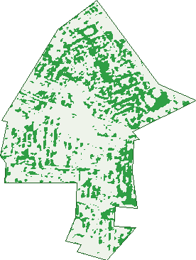
Green: 10 m cells where trees dominate, satellite 2021. Blue: water. The line is the suburb boundary.
| Canopy share, 1 m canopy height map, 2020 | 14.4% |
|---|---|
| Surveyed canopy, Greater Sydney aerial survey, 2019 | 18.5% |
| Land with trees, 10 m satellite map, 2021 | 23.6% |
Demographics
Unemployment 6.3% · Labour-force participation 62.7%
Population by age in Ashfield
| 0-4 | 981 |
|---|---|
| 5-14 | 1,715 |
| 15-19 | 753 |
| 20-24 | 1,956 |
| 25-34 | 5,272 |
| 35-44 | 3,531 |
| 45-54 | 2,561 |
| 55-64 | 2,378 |
| 65-74 | 1,816 |
| 75-84 | 1,237 |
| 85+ | 816 |
Dwelling types in Ashfield
| House | 2,047 |
|---|---|
| Townhouse | 682 |
| Apartment | 6,474 |
| Other | 42 |
Households by weekly income in Ashfield
| <$650 | 1,322 |
|---|---|
| $650-1,499 | 2,222 |
| $1,500-2,999 | 2,980 |
| $3,000+ | 2,276 |
Top ancestries in Ashfield
| Other | 5,148 |
|---|---|
| Chinese | 5,079 |
| English | 4,269 |
| Australian | 3,421 |
| Irish | 1,922 |
| Scottish | 1,299 |
Housing tenure in Ashfield
| Owned | 2,069 |
|---|---|
| Mortgage | 2,114 |
| Rented | 4,683 |
| Other | 282 |
Cars per household in Ashfield
| 0 | 2,091 |
|---|---|
| 1 | 4,850 |
| 2 | 1,658 |
| 3 | 348 |
| 4+ | 156 |
Commute to work in Ashfield
| Car | 2,984 |
|---|---|
| Train | 1,045 |
| Bus | 152 |
| Tram/ferry | 3 |
| Walked | 332 |
| Bicycle | 88 |
| Home | 4,991 |
Top countries of birth in Ashfield
| China | 2,814 |
|---|---|
| Nepal | 1,547 |
| India | 742 |
| Philippines | 670 |
| England | 491 |
| Italy | 375 |
Languages used at home in Ashfield
| Mandarin | 2,885 |
|---|---|
| Nepali | 1,557 |
| Cantonese | 1,214 |
| Italian | 501 |
| Spanish | 395 |
| Greek | 372 |
Birds & Wildlife Nearby
133,030 bird observations recorded near Ashfield — most often seen:
- Rainbow Lorikeet (12,972)
- Australian White Ibis (9,860)
- Noisy Miner (9,682)
- Common Myna (8,330)
- Australian Magpie (7,067)
- Rock Dove (6,979)
- Pied Currawong (5,901)
- Australian Raven (5,735)
- Spotted Turtle-dove (5,728)
- Welcome Swallow (4,910)
- Magpie-lark (4,404)
- Silver Gull (3,582)
- Red-whiskered Bulbul (3,451)
Show all 30 birds recorded near Ashfield
- Crested Pigeon (3,396)
- Grey Butcherbird (3,375)
- Sulphur-crested Cockatoo (3,350)
- Common Starling (3,108)
- Willie Wagtail (2,948)
- Silvereye (2,659)
- Laughing Kookaburra (2,612)
- Red Wattlebird (2,606)
- Superb Fairy-wren (2,600)
- White-faced Heron (2,545)
- Dusky Moorhen (2,402)
- Little Black Cormorant (2,338)
- Little Corella (2,233)
- Southern Noisy Miner (2,127)
- New Holland Honeyeater (2,051)
- Eastern Rainbow Lorikeet (2,050)
- Australasian Figbird (2,029)
Sightings reported by observers, not a survey, so the counts show what people record rather than what lives here. Source: Atlas of Living Australia.
Nearby Suburbs
The closest suburbs to Ashfield:
- Summer Hill (1.1 km)
- Croydon (1.2 km)
- Ashbury (1.5 km)
- Haberfield (1.6 km)
- Lewisham (2 km)
- Dulwich Hill (2.1 km)
- Burwood Heights (2.1 km)
- Hurlstone Park (2.3 km)
Embed this suburb
Add this free Ashfield stat card to your own site — just copy the code:
Preview:
Cite this page
Quoting these figures? Copy the credit line:
Keep an eye on Ashfield
One email when this data meaningfully changes — new census figures, prices, rankings. No spam, unsubscribe anytime.
Streets
- A'beckett Avenue (63)
- Albert Parade (163)
- Alexandra Street (12)
- Alma Street (40)
- Alt Street (840)
- Armstrong Street (29)
- Arthur Street (106)
- Ashford Street (17)
- Banks Street (13)
- Beatrice Street (46)
- Benalla Avenue (89)
- Blackwood Avenue (55)
- Bland Street (495)
- Broughton Street (14)
- Brown Street (458)
- Bruce Street (53)
- Brunswick Parade (132)
- Carlisle Street (76)
- Cavill Avenue (101)
- Cecil Street (393)
- Chandos Street (830)
- Charlotte Street (233)
- Church Street (249)
- Clissold Street (259)
- Comet Street (11)
- Crimson Lane (1)
- Crimson Street (3)
- Curt Street (55)
- Dengate Avenue (2)
- Dougan Street (22)
- Earle Avenue (25)
- Eccles Avenue (31)
- Elizabeth Street (434)
- Etonville Parade (16)
- Farleigh Street (35)
- Federal Avenue (20)
- Frederick Street (430)
- Goodwin Avenue (24)
- Gower Street (32)
- Grainger Avenue (116)
- Griffiths Street (17)
- Hampden Street (51)
- Hanks Street (92)
- Hardy Street (45)
- Hedger Avenue (17)
- Heighway Avenue (39)
- Henry Street (106)
- Hercules Street (246)
- Hillcrest Avenue (36)
- Holden Street (241)
- Holwood Avenue (11)
- Hugh Street (41)
- Ilford Avenue (9)
- John Street (86)
- Joseph Street (66)
- Julia Street (81)
- King Street (107)
- Knocklayde Street (197)
- Knox Street (25)
- Lapish Avenue (11)
- Liverpool Road (1,795)
- Loftus Street (212)
- Lucy Street (99)
- Mackay Street (13)
- Margaret Street (26)
- Markham Avenue (1)
- Markham Place (128)
- Miller Avenue (28)
- Milton Street (357)
- Milton Street N (41)
- Murrell Street (106)
- New Street (16)
- Nixon Avenue (8)
- Norton Street (419)
- Oak Street (43)
- Old Canterbury Road (14)
- Orchard Crescent (18)
- Ormond Street (211)
- Orpington Street (545)
- Page Avenue (33)
- Palace Street (204)
- Park Avenue (180)
- Parramatta Road (122)
- Pembroke Street (107)
- Pyrmont Street (15)
- Queen Street (297)
- Rectory Avenue (5)
- Richmond Avenue (12)
- Robert Street (85)
- Rose Street (87)
- Seaview Street (30)
- Service Avenue (63)
- Shepherd Street (41)
- Somerville Avenue (10)
- Station Street (6)
- Taringa Street (34)
- Tawa Street (10)
- The Avenue (109)
- The Esplanade (134)
- Thomas Street (137)
- Tideswell Street (26)
- Tintern Road (304)
- Victoria Square (37)
- Victoria Street (863)
- Vine Street (8)
- Wallace Street (74)
- Webbs Avenue (148)
- West Street (1)
- William Street (46)
- Wood Street (11)
- Woodlands Road (1)
- Yabsley Avenue (12)
- Yeo Avenue (24)