Artarmon NSW 2064
5,906 addresses · 71 streets
North Sydney Electorate › Willoughby LGA › Artarmon · 7 km from Sydney
📦 Thinking of moving here? Read the Artarmon moving guide

Living Here
Artarmon is a suburb of New South Wales, home to about 9,417 people, with a median age of 37. The typical household earns around $2,420 a week, with median rent near $525 a week. Most homes are apartments. About 48% of households own their home and 50% rent. Most workers work from home. Common community backgrounds include Chinese, English, Australian. On the ABS socio-economic scale it sits in decile 10 of 10 nationally — a relatively advantaged area.
Over time — Census 2001 → 2021
Dashed line: district figures for the Chatswood (East) - Artarmon statistical area (SA2), the smallest area the ABS published before 2011. Solid line: Artarmon itself.
Getting Around & Local Services
31 doctors & medical clinics
Getting around. Train station: Artarmon, 150 m north-east · Metro station: Chatswood, 1.5 km north · Bus interchange: Chatswood Transport Interchange, 1.6 km north · Ferry wharf: Northwood Wharf, 2.5 km south · Airport: Rose Bay Seaplane Base, 9.9 km south-east.
Socio-economic Standing
Deciles from 1 (lowest) to 10 (highest), against all Australian suburbs. The overall figure weighs advantage and disadvantage together; economic resources counts income and housing, and education & jobs counts qualifications and occupation. They often differ. Source: ABS SEIFA 2021.
Tree cover
🌳 Tree canopy: 19.2% share of land under canopy · satellite map, 2020
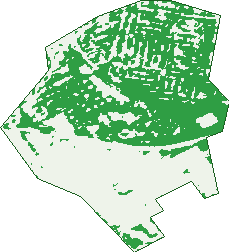
Green: 10 m cells where trees dominate, satellite 2021. Blue: water. The line is the suburb boundary.
| Canopy share, 1 m canopy height map, 2020 | 19.2% |
|---|---|
| Surveyed canopy, Greater Sydney aerial survey, 2019 | 27.0% |
| Land with trees, 10 m satellite map, 2021 | 50.5% |
Demographics
Unemployment 4.9% · Labour-force participation 67.9%
Population by age in Artarmon
| 0-4 | 517 |
|---|---|
| 5-14 | 1,339 |
| 15-19 | 402 |
| 20-24 | 477 |
| 25-34 | 1,464 |
| 35-44 | 1,926 |
| 45-54 | 1,230 |
| 55-64 | 874 |
| 65-74 | 702 |
| 75-84 | 345 |
| 85+ | 156 |
Dwelling types in Artarmon
| House | 820 |
|---|---|
| Townhouse | 320 |
| Apartment | 2,483 |
| Other | 3 |
Households by weekly income in Artarmon
| <$650 | 434 |
|---|---|
| $650-1,499 | 580 |
| $1,500-2,999 | 1,015 |
| $3,000+ | 1,428 |
Top ancestries in Artarmon
| Chinese | 2,376 |
|---|---|
| English | 1,931 |
| Other | 1,890 |
| Australian | 1,691 |
| Indian | 829 |
| Irish | 676 |
Housing tenure in Artarmon
| Owned | 897 |
|---|---|
| Mortgage | 830 |
| Rented | 1,811 |
| Other | 62 |
Cars per household in Artarmon
| 0 | 542 |
|---|---|
| 1 | 2,040 |
| 2 | 850 |
| 3 | 124 |
| 4+ | 35 |
Commute to work in Artarmon
| Car | 1,000 |
|---|---|
| Train | 270 |
| Bus | 31 |
| Tram/ferry | 0 |
| Walked | 185 |
| Bicycle | 16 |
| Home | 2,715 |
Top countries of birth in Artarmon
| China | 968 |
|---|---|
| India | 697 |
| Hong Kong | 298 |
| England | 279 |
| Japan | 186 |
| Philippines | 179 |
Languages used at home in Artarmon
| Mandarin | 1,171 |
|---|---|
| Cantonese | 617 |
| Hindi | 327 |
| Japanese | 284 |
| Nepali | 158 |
| Thai | 148 |
Birds & Wildlife Nearby
117,115 bird observations recorded near Artarmon — most often seen:
- Rainbow Lorikeet (14,060)
- Noisy Miner (11,064)
- Laughing Kookaburra (7,404)
- Australian Brush-turkey (7,320)
- Australian Magpie (7,071)
- Sulphur-crested Cockatoo (6,916)
- Pied Currawong (6,651)
- Grey Butcherbird (4,644)
- Australian Raven (4,516)
- Welcome Swallow (3,989)
- Australian White Ibis (3,119)
- White-browed Scrubwren (3,019)
- Rock Dove (2,738)
Show all 30 birds recorded near Artarmon
- Australian King-parrot (2,650)
- Eastern Whipbird (2,620)
- Silver Gull (2,340)
- Australian Wood Duck (2,281)
- Common Myna (2,272)
- Superb Fairy-wren (2,212)
- Brown Thornbill (2,086)
- Tawny Frogmouth (2,079)
- Channel-billed Cuckoo (2,007)
- White-faced Heron (1,891)
- Masked Lapwing (1,808)
- Silvereye (1,763)
- Spotted Pardalote (1,752)
- Little Black Cormorant (1,749)
- Pacific Black Duck (1,737)
- Eastern Spinebill (1,679)
- Crested Pigeon (1,678)
Sightings reported by observers, not a survey, so the counts show what people record rather than what lives here. Source: Atlas of Living Australia.
Nearby Suburbs
The closest suburbs to Artarmon:
- Willoughby (1.5 km)
- Chatswood (1.5 km)
- Naremburn (1.7 km)
- Greenwich (1.8 km)
- St Leonards (1.8 km)
- Lane Cove North (1.8 km)
- Lane Cove (2 km)
- Northwood (2.1 km)
Embed this suburb
Add this free Artarmon stat card to your own site — just copy the code:
Preview:
Cite this page
Quoting these figures? Copy the credit line:
Keep an eye on Artarmon
One email when this data meaningfully changes — new census figures, prices, rankings. No spam, unsubscribe anytime.
Streets
- Abbott Road (3)
- Alto Place (1)
- Artarmon Road (100)
- Barton Road (287)
- Benton Avenue (65)
- Brand Street (42)
- Broadcast Way (11)
- Broughton Road (454)
- Buller Road (131)
- Burra Road (53)
- Cambridge Road (29)
- Cameron Avenue (31)
- Campbell Street (54)
- Carlos Road (34)
- Carlotta Street (48)
- Chelmsford Avenue (2)
- Clarendon Street (36)
- Cleg Street (25)
- Cleland Road (139)
- Cooney Road (19)
- Coree Road (11)
- Dickson Avenue (137)
- Drake Street (13)
- Elizabeth Street (125)
- Eric Road (171)
- Francis Road (366)
- Frederick Street (24)
- French Street (12)
- George Place (24)
- Godfrey Road (37)
- Hampden Lane (6)
- Hampden Road (721)
- Harden Road (14)
- Hawkins Street (13)
- Herbert Street (73)
- Hotham Parade (123)
- Jersey Road (380)
- Kitchener Road (57)
- Lambs Road (10)
- Lanceley Place (43)
- Marden Street (11)
- Marlow Road (2)
- Mclachlan Avenue (21)
- Mcmillan Road (70)
- Milner Road (176)
- Mowbray Road (166)
- Muttama Road (47)
- Onyx Road (30)
- Pacific Highway (341)
- Palmer Street (73)
- Parkes Road (166)
- Punch Street (18)
- Pyrl Road (12)
- Raleigh Street (8)
- Reserve Road (171)
- Rimmington Street (11)
- Robert Street (99)
- Sawyer Lane (1)
- Selwyn Street (20)
- Shepherd Road (44)
- Smith Road (43)
- Stafford Road (76)
- Stewart Street (31)
- Sydney Street (27)
- Tindale Road (70)
- Waltham Street (52)
- Weedon Road (30)
- Westbourne Street (2)
- White Street (5)
- Whiting Street (143)
- Wilkes Avenue (16)