Albion Park NSW 2527
6,409 addresses · 188 streets
Whitlam Electorate › Shellharbour LGA › Albion Park · 89 km from Sydney
📦 Thinking of moving here? Read the Albion Park moving guide

Living Here
Albion Park is a suburb of New South Wales, home to about 13,826 people, with a median age of 36. The typical household earns around $1,938 a week, with median rent near $460 a week. Most homes are houses. About 82% of households own their home and 18% rent. Most workers drive to work. Common community backgrounds include English, Australian, Scottish. On the ABS socio-economic scale it sits in decile 5 of 10 nationally — a mid-range area.
Over time — Census 2001 → 2021
Dashed line: district figures for the Albion Park - Macquarie Pass statistical area (SA2), the smallest area the ABS published before 2011. Solid line: Albion Park itself.
Getting Around & Local Services
2 supermarkets
1 Catholic church
3 doctors & medical clinics
1 post office
10 service stations
5 gyms & sports centres
1 playground
2 dog parks
3 hardware stores
1 electrician
Getting around. Train station: Albion Park, 3 km north-east · Airport: Shellharbour Airport, 2.8 km north-east.
Socio-economic Standing
Deciles from 1 (lowest) to 10 (highest), against all Australian suburbs. The overall figure weighs advantage and disadvantage together; economic resources counts income and housing, and education & jobs counts qualifications and occupation. They often differ. Source: ABS SEIFA 2021.
Tree cover
🌳 Tree canopy: 13.4% share of land under canopy · satellite map, 2020
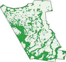
Green: 10 m cells where trees dominate, satellite 2021. Blue: water. The line is the suburb boundary.
| Canopy share, 1 m canopy height map, 2020 | 13.4% |
|---|---|
| Land with trees, 10 m satellite map, 2021 | 30.7% |
Demographics
Unemployment 3.2% · Labour-force participation 65.3%
Population by age in Albion Park
| 0-4 | 867 |
|---|---|
| 5-14 | 1,988 |
| 15-19 | 942 |
| 20-24 | 900 |
| 25-34 | 1,868 |
| 35-44 | 1,717 |
| 45-54 | 1,871 |
| 55-64 | 1,690 |
| 65-74 | 1,110 |
| 75-84 | 591 |
| 85+ | 285 |
Dwelling types in Albion Park
| House | 4,004 |
|---|---|
| Townhouse | 672 |
| Apartment | 23 |
| Other | 4 |
Households by weekly income in Albion Park
| <$650 | 530 |
|---|---|
| $650-1,499 | 1,176 |
| $1,500-2,999 | 1,611 |
| $3,000+ | 1,068 |
Top ancestries in Albion Park
| English | 5,921 |
|---|---|
| Australian | 5,863 |
| Scottish | 1,376 |
| Irish | 1,326 |
| Other | 933 |
| German | 731 |
Housing tenure in Albion Park
| Owned | 1,487 |
|---|---|
| Mortgage | 2,312 |
| Rented | 824 |
| Other | 37 |
Cars per household in Albion Park
| 0 | 130 |
|---|---|
| 1 | 1,224 |
| 2 | 1,940 |
| 3 | 790 |
| 4+ | 564 |
Commute to work in Albion Park
| Car | 4,346 |
|---|---|
| Train | 18 |
| Bus | 12 |
| Tram/ferry | 0 |
| Walked | 45 |
| Bicycle | 7 |
| Home | 1,183 |
Top countries of birth in Albion Park
| England | 586 |
|---|---|
| New Zealand | 117 |
| Germany | 88 |
| Scotland | 77 |
| Philippines | 69 |
| Italy | 44 |
Languages used at home in Albion Park
| Macedonian | 83 |
|---|---|
| Spanish | 83 |
| Italian | 42 |
| Mandarin | 41 |
| German | 40 |
| Arabic | 36 |
Birds & Wildlife Nearby
42,484 bird observations recorded near Albion Park — most often seen:
- Magpie-lark (2,453)
- Australian Magpie (2,152)
- Rainbow Lorikeet (2,060)
- Common Myna (2,034)
- Willie Wagtail (1,831)
- Australian Raven (1,775)
- Welcome Swallow (1,770)
- White-faced Heron (1,571)
- Masked Lapwing (1,560)
- Superb Fairy-wren (1,517)
- Pacific Black Duck (1,468)
- Australian White Ibis (1,467)
- Grey Butcherbird (1,424)
Show all 30 birds recorded near Albion Park
- Australian Pelican (1,380)
- Little Pied Cormorant (1,350)
- Chestnut Teal (1,333)
- Noisy Miner (1,332)
- Galah (1,316)
- Black Swan (1,270)
- Spotted Turtle-dove (1,162)
- Crested Pigeon (1,148)
- Sulphur-crested Cockatoo (1,116)
- Great Egret (1,086)
- Red Wattlebird (1,060)
- Little Corella (1,026)
- Red-whiskered Bulbul (1,006)
- Royal Spoonbill (993)
- Little Black Cormorant (957)
- Silver Gull (935)
- Pied Currawong (932)
Sightings reported by observers, not a survey, so the counts show what people record rather than what lives here. Source: Atlas of Living Australia.
Nearby Suburbs
The closest suburbs to Albion Park:
- Tullimbar (1.9 km)
- North Macquarie (2.8 km)
- Croom (2.9 km)
- Albion Park Rail (2.9 km)
- Calderwood (3.4 km)
- Yellow Rock Ridge (3.5 km)
- Yellow Rock (3.6 km)
- Oak Flats (4.6 km)
Embed this suburb
Add this free Albion Park stat card to your own site — just copy the code:
Preview:
Cite this page
Quoting these figures? Copy the credit line:
Keep an eye on Albion Park
One email when this data meaningfully changes — new census figures, prices, rankings. No spam, unsubscribe anytime.
Streets
- Abercrombie Crescent (29)
- Aitken Close (15)
- Amaral Avenue (40)
- Ashburton Drive (81)
- Ashton Close (35)
- Avoca Place (9)
- Avon Close (14)
- Badgery Street (52)
- Banjo Street (48)
- Barcoo Circuit (48)
- Barwon Place (14)
- Beaufort Court (4)
- Bellinger Terrace (19)
- Bendora Street (2)
- Beveridge Street (43)
- Boles Street (6)
- Boondooma Street (9)
- Borrowdale Close (45)
- Bower Place (6)
- Brae Road (60)
- Burdekin Drive (135)
- Burnett Place (19)
- Calderwood Road (37)
- Campaspe Circuit (83)
- Canning Place (11)
- Cascade Circuit (36)
- Cawdell Drive (81)
- Centenary Road (48)
- Chaffey Way (51)
- Chaplin Place (35)
- Charlotte Crescent (58)
- Cheffins Place (9)
- Chinchilla Way (26)
- Church Street (145)
- Clermont Crescent (30)
- Collie Way (19)
- Colo Place (4)
- Condon Street (1)
- Cook Close (3)
- Cooper Place (8)
- Crest Road (135)
- Daintree Drive (216)
- Dalrymple Street (14)
- Danjera Drive (26)
- Darling Drive (57)
- Darling Mills Road (24)
- Dawson Place (19)
- Derwent Place (27)
- Diamantina Circuit (19)
- Digby Close (8)
- Dovers Avenue (19)
- Downes Drive (39)
- Drysdale Road (27)
- Dudgeon Street (22)
- Duke Street (8)
- Ellenbrook Way (23)
- Esperance Drive (117)
- Farmer Place (5)
- Federation Place (23)
- Fields Drive (61)
- Fishburn Place (4)
- Fleet Crescent (17)
- Fortescue Court (15)
- Franklin Place (21)
- Fraser Crescent (32)
- Friendship Link (5)
- Fryer Place (11)
- Gascoyne Street (8)
- Gear Circuit (19)
- Gellibrand Street (10)
- Gloucester Circuit (62)
- Golden Grove (19)
- Goonyella Street (16)
- Graham Street (10)
- Grey Street (46)
- Halket Lane (1)
- Hamilton Road (16)
- Harris Street (7)
- Hawkesbury Place (10)
- Hazelton Street (21)
- Headwater Place (34)
- Helena Place (17)
- Hillside Drive (106)
- Holroyd Street (58)
- Hughes Drive (29)
- Huon Crescent (27)
- Illawarra Highway (12)
- Isabella Drive (1)
- Jamberoo Road (5)
- Jeffcoat Street (38)
- Kalgan Way (8)
- Katherine Street (7)
- Kevin Road (6)
- Kingsley Avenue (12)
- Liam Close (10)
- Loddon Circuit (42)
- Macalister Terrace (15)
- Macleay Place (38)
- Macquarie Street (82)
- Manning Place (15)
- Margaret Place (6)
- Marsh Place (22)
- Mayfield Circuit (67)
- Mayo Close (6)
- Mccleerey Place (7)
- Mccoy Place (4)
- Mcgill Close (12)
- Mcgrath Lane (20)
- Mcinerney Avenue (18)
- Medlow Way (6)
- Michael Street (24)
- Moles Street (44)
- Molongo Street (11)
- Mood Circuit (17)
- Mortlock Drive (56)
- Moruya Link (13)
- Mountainview Mews (28)
- Munduran Close (29)
- Murchison Street (30)
- Murray Close (20)
- Napier Place (11)
- Nattai Crescent (20)
- Nepean Place (17)
- Noble Road (55)
- Normanby Place (11)
- O'gorman Street (83)
- O'keefe Crescent (37)
- Ord Place (6)
- Parsons Place (11)
- Pleasant View Close (24)
- Polock Crescent (49)
- Premier Drive (37)
- Propane Street (48)
- Raftery Street (3)
- Raleigh Street (105)
- Red Gum Road (23)
- Redbank Place (6)
- Richmond Place (18)
- Robb Street (9)
- Roper Road (64)
- Russell Street (84)
- Samuel Circuit (31)
- Sawtell Street (29)
- Scarborough Circuit (47)
- Scenic Crescent (79)
- Severn Place (34)
- Shannon Drive (45)
- Simpson Parade (54)
- Sirius Court (7)
- Skardon Terrace (15)
- Smith Avenue (29)
- Sophia Street (58)
- Springwood Street (13)
- Stapleton Avenue (7)
- State Place (9)
- Stephens Street (25)
- Stirling Place (8)
- Stubbs Road (46)
- Supply Court (5)
- Swan Place (16)
- Tallowood Street (15)
- Taylor Road (178)
- Terry Street (279)
- The Billabong (16)
- The Expressway (13)
- Todd Link (12)
- Tomlin Street (12)
- Tongarra Road (435)
- Torrens Place (19)
- Tripoli Way (39)
- Tully Crescent (18)
- Tuross Street (26)
- Tweed Link (10)
- Ulan Place (22)
- Uphill Road (1)
- Upland Chase (110)
- Valley View Crescent (33)
- Walsh Place (4)
- Warrego Street (14)
- Waterford Terrace (10)
- Weston Street (7)
- Whistlers Run (71)
- Wiley Street (26)
- Windermere Avenue (14)
- Wolfgang Road (33)
- Yarra Close (4)
- Yolanda Street (20)
- Yulara Drive (31)