Weston ACT 2611
2,382 addresses · 74 streets
Bean Electorate › Unincorporated ACT LGA › Weston · 9 km from Canberra
📦 Thinking of moving here? Read the Weston moving guide

Living Here
Weston is a suburb of Australian Capital Territory, home to about 4,000 people, with a median age of 42. The typical household earns around $2,361 a week, with median rent near $420 a week. Most homes are houses. About 75% of households own their home and 23% rent. Most workers drive to work. Common community backgrounds include English, Australian, Irish. On the ABS socio-economic scale it sits in decile 10 of 10 nationally — a relatively advantaged area.
Over time — Census 2001 → 2021
Dashed line: district figures for the Weston statistical area (SA2), the smallest area the ABS published before 2011. Solid line: Weston itself.
Getting Around & Local Services
1 optometrist
1 library
27 playgrounds
- Fry Place Neighbourhood Playground
- Weston Community Park Playground
- Dillon Close Pedestrian Parkland Playground
- Whitney Place - Pedestrian Parkland
- Gruner Street Neighbourhood Playground
- Withers Place Neighbourhood Playground
- Pearson Street Neighbourhood Playground
- Molvig Street Neighbourhood Playground
- Bunbury Street Central Community Playground
- Calder Crescent Nneighboourhood Playground
1 dog park
1 butcher
1 plumber
1 place to stay
Getting around. Train station: Canberra, 8.6 km east · Bus interchange: Tuggeranong Bus Interchange, 8.5 km south · Airport: Canberra Airport, 13 km east.
Socio-economic Standing
Deciles from 1 (lowest) to 10 (highest), against all Australian suburbs. The overall figure weighs advantage and disadvantage together; economic resources counts income and housing, and education & jobs counts qualifications and occupation. They often differ. Source: ABS SEIFA 2021.
Tree cover
🌳 Tree canopy: 12.1% share of land under canopy · satellite map, 2020
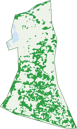
Green: 10 m cells where trees dominate, satellite 2021. Blue: water. The line is the suburb boundary.
| Canopy share, 1 m canopy height map, 2020 | 12.1% |
|---|---|
| Land with trees, 10 m satellite map, 2021 | 34.1% |
Demographics
Unemployment 3.5% · Labour-force participation 60.8%
Population by age in Weston
| 0-4 | 228 |
|---|---|
| 5-14 | 530 |
| 15-19 | 208 |
| 20-24 | 188 |
| 25-34 | 420 |
| 35-44 | 568 |
| 45-54 | 547 |
| 55-64 | 372 |
| 65-74 | 402 |
| 75-84 | 367 |
| 85+ | 175 |
Dwelling types in Weston
| House | 1,091 |
|---|---|
| Townhouse | 308 |
| Apartment | 68 |
| Other | 0 |
Households by weekly income in Weston
| <$650 | 171 |
|---|---|
| $650-1,499 | 268 |
| $1,500-2,999 | 392 |
| $3,000+ | 563 |
Top ancestries in Weston
| English | 1,388 |
|---|---|
| Australian | 1,337 |
| Other | 615 |
| Irish | 524 |
| Scottish | 496 |
| German | 206 |
Housing tenure in Weston
| Owned | 532 |
|---|---|
| Mortgage | 553 |
| Rented | 330 |
| Other | 34 |
Cars per household in Weston
| 0 | 72 |
|---|---|
| 1 | 586 |
| 2 | 581 |
| 3 | 147 |
| 4+ | 71 |
Commute to work in Weston
| Car | 1,237 |
|---|---|
| Train | 0 |
| Bus | 82 |
| Tram/ferry | 0 |
| Walked | 24 |
| Bicycle | 40 |
| Home | 234 |
Top countries of birth in Weston
| England | 119 |
|---|---|
| India | 83 |
| China | 53 |
| New Zealand | 47 |
| Malaysia | 43 |
| Germany | 37 |
Languages used at home in Weston
| Mandarin | 71 |
|---|---|
| French | 40 |
| German | 32 |
| Spanish | 32 |
| Italian | 30 |
| Persian | 26 |
Birds & Wildlife Nearby
642,166 bird observations recorded near Weston — most often seen:
- Australian Magpie (46,226)
- Pied Currawong (40,686)
- Magpie-lark (40,265)
- Sulphur-crested Cockatoo (39,313)
- Galah (35,748)
- Red Wattlebird (35,654)
- Crimson Rosella (31,099)
- Australian Raven (27,201)
- Common Myna (25,839)
- Australian King-parrot (24,143)
- Silvereye (23,538)
- Crested Pigeon (23,132)
- Eastern Rosella (23,063)
Show all 30 birds recorded near Weston
- Common Starling (22,392)
- Eurasian Blackbird (21,770)
- House Sparrow (21,057)
- Noisy Miner (16,238)
- Gang-gang Cockatoo (15,661)
- Rock Dove (13,295)
- Superb Fairy-wren (13,011)
- Yellow-rumped Thornbill (12,855)
- Spotted Pardalote (12,739)
- Eastern Spinebill (12,031)
- Noisy Friarbird (10,206)
- Black-faced Cuckoo-shrike (9,842)
- Striated Pardalote (9,677)
- Yellow-faced Honeyeater (9,174)
- Weebill (9,093)
- Willie Wagtail (8,732)
- Grey Fantail (8,486)
Sightings reported by observers, not a survey, so the counts show what people record rather than what lives here. Source: Atlas of Living Australia.
Nearby Suburbs
The closest suburbs to Weston:
Embed this suburb
Add this free Weston stat card to your own site — just copy the code:
Preview:
Cite this page
Quoting these figures? Copy the credit line:
Keep an eye on Weston
One email when this data meaningfully changes — new census figures, prices, rankings. No spam, unsubscribe anytime.
Streets
- Auld Place (6)
- Backler Place (15)
- Bellette Street (26)
- Bock Place (5)
- Brierly Street (300)
- Bryant Place (10)
- Bunny Street (27)
- Buvelot Street (56)
- Cazneaux Crescent (27)
- Chevalier Street (100)
- Coates Place (8)
- Collingridge Street (22)
- Conder Street (21)
- Cotter Road (20)
- Daplyn Close (7)
- Dargie Street (14)
- Dillon Close (2)
- Evergood Close (48)
- Fereday Street (13)
- Fizelle Place (14)
- Folingsby Street (52)
- Fowles Street (40)
- Fry Place (6)
- Fullwood Street (28)
- Geoff Bardon Street (12)
- Gray Place (6)
- Gritten Street (31)
- Gruner Street (44)
- Heysen Street (45)
- Hickey Court (3)
- Hilder Street (74)
- Hopkins Street (31)
- Ironside Street (25)
- Isherwood Street (22)
- Jerrems Crescent (22)
- Kirkpatrick Street (10)
- Leist Street (37)
- Liardet Street (22)
- Lycett Street (35)
- Macnally Street (1)
- Mahony Court (19)
- Malangi Street (9)
- Martens Crescent (25)
- Mather Street (55)
- Mcconchie Circuit (25)
- Mccubbin Street (60)
- Mcinnes Street (91)
- Meldrum Street (37)
- Minns Place (8)
- Molvig Street (20)
- Mount Stromlo Road (6)
- Namatjira Drive (129)
- Parkinson Street (12)
- Peg Minty Crescent (7)
- Preston Street (23)
- Prout Place (14)
- Rivers Street (29)
- Rowell Place (14)
- Rubbo Crescent (33)
- Sellbach Street (48)
- Shiga Street (8)
- Shirlow Place (10)
- Shore Place (14)
- Skipper Close (4)
- Souter Place (16)
- Sturgess Place (11)
- Tom Bass Terrace (2)
- Trenerry Street (216)
- Unwin Place (2)
- Unwin Street (8)
- Wakelin Circuit (59)
- Watling Place (54)
- Whitney Place (3)
- Withers Place (24)