Taylor ACT 2913
3,470 addresses · 112 streets
Fenner Electorate › Unincorporated ACT LGA › Taylor · 15 km from Canberra
📦 Thinking of moving here? Read the Taylor moving guide

Living Here
Taylor is a suburb of Australian Capital Territory, home to about 2,220 people, with a median age of 30. The typical household earns around $2,655 a week, with median rent near $282 a week. Most homes are houses. About 74% of households own their home and 25% rent. Most workers drive to work. Common community backgrounds include Indian, Australian, English. On the ABS socio-economic scale it sits in decile 10 of 10 nationally — a relatively advantaged area.
Getting Around & Local Services
4 supermarkets
2 Catholic churches
1 pharmacy
1 medical clinic
1 childcare centre
1 library
2 golf clubs
11 playgrounds
- Sutherland Crescent Central Community Playground
- Mottram Street Neighbourhood Playground
- Dawson Park Playground
- Kavangal Circuit Neighbourhood Playground
- Greg Irwin Circuit Neighbourhood Playground
- Moncrieff Community Recreation Park Playground
- Whitrod Avenue Neighbouhood Playground
- Burrumarra Avenue Neighbourhood Playground
- Bindugan Crescent Neighbourhood Playground
- Crackerjack Way Neighbourhood Playground
1 dog park
1 hardware store
1 beauty salon
2 mechanics
3 places to stay
Getting around. Light rail stop: Gungahlin Place, 4.8 km south-east · Bus interchange: Gungahlin Bus Station, 4.7 km south-east · Airport: Canberra Airport, 19 km south-east.
Socio-economic Standing
Deciles from 1 (lowest) to 10 (highest), against all Australian suburbs. The overall figure weighs advantage and disadvantage together; economic resources counts income and housing, and education & jobs counts qualifications and occupation. They often differ. Source: ABS SEIFA 2021.
Tree cover
🌳 Tree canopy: 9.2% share of land under canopy · satellite map, 2020
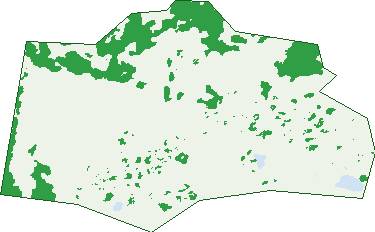
Green: 10 m cells where trees dominate, satellite 2021. Blue: water. The line is the suburb boundary.
| Canopy share, 1 m canopy height map, 2020 | 9.2% |
|---|---|
| Land with trees, 10 m satellite map, 2021 | 15.2% |
Demographics
Unemployment 3.5% · Labour-force participation 75.5%
Population by age in Taylor
| 0-4 | 261 |
|---|---|
| 5-14 | 383 |
| 15-19 | 81 |
| 20-24 | 120 |
| 25-34 | 549 |
| 35-44 | 495 |
| 45-54 | 152 |
| 55-64 | 98 |
| 65-74 | 69 |
| 75-84 | 18 |
| 85+ | 3 |
Dwelling types in Taylor
| House | 521 |
|---|---|
| Townhouse | 101 |
| Apartment | 3 |
| Other | 0 |
Households by weekly income in Taylor
| <$650 | 55 |
|---|---|
| $650-1,499 | 70 |
| $1,500-2,999 | 235 |
| $3,000+ | 241 |
Top ancestries in Taylor
| Other | 846 |
|---|---|
| Indian | 540 |
| Australian | 371 |
| English | 295 |
| Chinese | 111 |
| Ancestry NS | 101 |
Housing tenure in Taylor
| Owned | 23 |
|---|---|
| Mortgage | 440 |
| Rented | 156 |
| Other | 10 |
Cars per household in Taylor
| 0 | 18 |
|---|---|
| 1 | 175 |
| 2 | 310 |
| 3 | 77 |
| 4+ | 36 |
Commute to work in Taylor
| Car | 856 |
|---|---|
| Train | 8 |
| Bus | 22 |
| Tram/ferry | 5 |
| Walked | 0 |
| Bicycle | 6 |
| Home | 94 |
Top countries of birth in Taylor
| India | 533 |
|---|---|
| Pakistan | 92 |
| Nepal | 50 |
| China | 43 |
| Sri Lanka | 40 |
| Bangladesh | 38 |
Languages used at home in Taylor
| Punjabi | 304 |
|---|---|
| Hindi | 125 |
| Urdu | 120 |
| Gujarati | 105 |
| Mandarin | 63 |
| Nepali | 59 |
Birds & Wildlife Nearby
101,495 bird observations recorded near Taylor — most often seen:
- Galah (5,850)
- Sulphur-crested Cockatoo (5,815)
- Australian Magpie (5,782)
- Magpie-lark (5,481)
- Australian Raven (4,628)
- Common Starling (4,614)
- Crimson Rosella (4,441)
- Red Wattlebird (4,076)
- Common Myna (3,954)
- Crested Pigeon (3,601)
- Eastern Rosella (3,350)
- Pied Currawong (3,302)
- Noisy Miner (3,089)
Show all 30 birds recorded near Taylor
- House Sparrow (3,039)
- Pacific Black Duck (3,025)
- Welcome Swallow (3,016)
- Eurasian Coot (3,014)
- Willie Wagtail (2,847)
- Australian Wood Duck (2,842)
- Red-rumped Parrot (2,820)
- Dusky Moorhen (2,708)
- Australian White Ibis (2,619)
- Australasian Purple Swamphen (2,596)
- Superb Fairy-wren (2,480)
- Striated Pardalote (2,190)
- Australasian Grebe (2,136)
- Yellow-rumped Thornbill (2,125)
- Little Pied Cormorant (2,052)
- Eurasian Blackbird (2,006)
- Black Swan (1,997)
Sightings reported by observers, not a survey, so the counts show what people record rather than what lives here. Source: Atlas of Living Australia.
Nearby Suburbs
The closest suburbs to Taylor:
Embed this suburb
Add this free Taylor stat card to your own site — just copy the code:
Preview:
Cite this page
Quoting these figures? Copy the credit line:
Keep an eye on Taylor
One email when this data meaningfully changes — new census figures, prices, rankings. No spam, unsubscribe anytime.
Streets
- Alison Burton Rise (16)
- Alistair Knox Terrace (13)
- Alldritt Lane (7)
- Ambler View (10)
- Ancher Street (106)
- Anthoness Street (25)
- Arney Close (8)
- Baldwinson Street (12)
- Bayne Street (11)
- Bea Hutton Close (14)
- Bebarfalds Lane (8)
- Berenice Street (23)
- Beryl Mann View (5)
- Birtwistle Street (13)
- Bischoff Street (36)
- Bloomfield Crescent (41)
- Bolot Close (7)
- Borland Street (16)
- Briger Street (57)
- Buhrich Street (5)
- Butterworth Street (14)
- Chadwick Street (36)
- Chenoweth Street (10)
- Claridge Street (39)
- Cobden Street (10)
- Col James Way (8)
- Corkery Crescent (138)
- Crone Terrace (29)
- Cullis Hill Terrace (14)
- Devenish Street (105)
- Don Gazzard View (14)
- Dorney Rise (40)
- Edwin Oribin Street (28)
- Ellis Stones Terrace (25)
- Elsie Cornish Way (13)
- Esplin Street (24)
- Everist Street (94)
- Feilman Street (60)
- Frazer Simons Way (12)
- Gargett Street (3)
- Gassick Street (22)
- George Seddon Crescent (42)
- Gordon Ford Way (19)
- Grassick Street (22)
- Greg Mcnamara Crescent (5)
- Grenfell Avenue (107)
- Gruzman View (16)
- Harry Seidler Crescent (79)
- Haskell Way (9)
- Hilda Kirkhope Terrace (7)
- Holford Street (24)
- Holgar Crescent (39)
- Ina Higgins Street (13)
- Ingpen Street (2)
- Iwanoff Street (8)
- Janice Seto Street (31)
- Jelinek Street (32)
- Judith Macintosh Crescent (46)
- Karl Langer Crescent (10)
- Ken Herde Crescent (42)
- Kitty Henry Rise (12)
- Knitlock Street (9)
- Koch Street (10)
- Langmead Street (18)
- Ledgar Rise (11)
- Lidbury Street (13)
- Margules Crescent (68)
- Marjorie Matthews Street (22)
- Mayes Street (4)
- Mccardell Street (13)
- Mccredie Street (46)
- Mcglashan Street (48)
- Mees Street (9)
- Mervyn Davis Crescent (10)
- Mollie Shaw Way (15)
- Morath Street (9)
- Mottram Street (13)
- Nell Edeson Street (31)
- Nethercote Street (17)
- Olive Mellor Terrace (7)
- Pegg Wilks Street (11)
- Pejar Terrace (7)
- Perrott Street (26)
- Pholeros Way (16)
- Proudfoot Rise (42)
- Pumpurs Crescent (24)
- Radburn Street (2)
- Richard Clough View (14)
- Robin Boyd Crescent (248)
- Romberg Way (36)
- Rosette Rise (9)
- Ruzicka Street (55)
- Scorer Street (9)
- Shugg Street (69)
- Sievers View (17)
- Sodersten Street (32)
- Soderston Street (17)
- Spooner Street (9)
- Summerhayes Street (15)
- Sunnyman Street (39)
- Sutherland Crescent (359)
- Thelander Street (22)
- Torzillo Street (10)
- Trevor Gibson Way (49)
- Trewenack Street (19)
- Trundle Street (45)
- Ussher Street (16)
- Vahland Street (55)
- Whitman Crescent (27)
- Winsome Street (15)
- Woodward Loop (26)
- Yali Street (21)