Kaleen ACT 2617
3,354 addresses · 90 streets
Canberra Electorate › Unincorporated ACT LGA › Kaleen · 6 km from Canberra
📦 Thinking of moving here? Read the Kaleen moving guide

Living Here
Kaleen is a suburb of Australian Capital Territory, home to about 7,672 people, with a median age of 39. The typical household earns around $2,336 a week, with median rent near $460 a week. Most homes are houses. About 74% of households own their home and 25% rent. Most workers drive to work. Common community backgrounds include Australian, English, Irish. On the ABS socio-economic scale it sits in decile 9 of 10 nationally — a relatively advantaged area.
Over time — Census 2001 → 2021
Dashed line: district figures for the Kaleen statistical area (SA2), the smallest area the ABS published before 2011. Solid line: Kaleen itself.
Getting Around & Local Services
2 pharmacies
5 optometrists
7 service stations
20 playgrounds
- Wakool Circuit Neighbourhood Playground
- Ashburton Circuit Neighbourhood Playground
- Georgina Crescent Neighbourhood Playground
- Ellenborough Street Neighbourhood Playground
- Liffey Circuit Neighbourhood Playground
- Bellinger Court Neighbourhood Playground
- Warrego Circuit Neighbourhood Playground
- Kaleen Shopping Centre Neighbourhood Playground
- Sculptor Street Neighbourhood Playground
- Darby Street Neighbourhood Playground
1 dog park
2 bakeries
4 hairdressers
2 beauty salons
1 plumber
Getting around. Train station: Canberra, 11.1 km south · Light rail stop: Swinden Street, 3.2 km south-east · Bus interchange: Belconnen Community Bus Station, 3.8 km south-west · Airport: Canberra Airport, 11.8 km south-east.
Socio-economic Standing
Deciles from 1 (lowest) to 10 (highest), against all Australian suburbs. The overall figure weighs advantage and disadvantage together; economic resources counts income and housing, and education & jobs counts qualifications and occupation. They often differ. Source: ABS SEIFA 2021.
Tree cover
🌳 Tree canopy: 9.8% share of land under canopy · satellite map, 2020
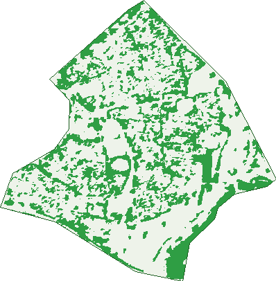
Green: 10 m cells where trees dominate, satellite 2021. Blue: water. The line is the suburb boundary.
| Canopy share, 1 m canopy height map, 2020 | 9.8% |
|---|---|
| Land with trees, 10 m satellite map, 2021 | 28.0% |
Demographics
Unemployment 4% · Labour-force participation 62.7%
Population by age in Kaleen
| 0-4 | 427 |
|---|---|
| 5-14 | 953 |
| 15-19 | 416 |
| 20-24 | 450 |
| 25-34 | 1,018 |
| 35-44 | 1,105 |
| 45-54 | 900 |
| 55-64 | 864 |
| 65-74 | 988 |
| 75-84 | 415 |
| 85+ | 130 |
Dwelling types in Kaleen
| House | 2,442 |
|---|---|
| Townhouse | 154 |
| Apartment | 81 |
| Other | 0 |
Households by weekly income in Kaleen
| <$650 | 264 |
|---|---|
| $650-1,499 | 488 |
| $1,500-2,999 | 818 |
| $3,000+ | 955 |
Top ancestries in Kaleen
| Australian | 2,379 |
|---|---|
| English | 2,365 |
| Other | 1,142 |
| Irish | 900 |
| Scottish | 765 |
| Chinese | 548 |
Housing tenure in Kaleen
| Owned | 1,057 |
|---|---|
| Mortgage | 906 |
| Rented | 657 |
| Other | 17 |
Cars per household in Kaleen
| 0 | 124 |
|---|---|
| 1 | 843 |
| 2 | 1,091 |
| 3 | 380 |
| 4+ | 214 |
Commute to work in Kaleen
| Car | 2,498 |
|---|---|
| Train | 7 |
| Bus | 129 |
| Tram/ferry | 11 |
| Walked | 40 |
| Bicycle | 112 |
| Home | 416 |
Top countries of birth in Kaleen
| China | 294 |
|---|---|
| England | 211 |
| India | 192 |
| Vietnam | 118 |
| Philippines | 86 |
| New Zealand | 81 |
Languages used at home in Kaleen
| Mandarin | 350 |
|---|---|
| Vietnamese | 145 |
| Greek | 102 |
| Croatian | 92 |
| Spanish | 83 |
| Italian | 76 |
Birds & Wildlife Nearby
592,104 bird observations recorded near Kaleen — most often seen:
- Australian Magpie (37,942)
- Red Wattlebird (36,404)
- Pied Currawong (34,764)
- Magpie-lark (34,430)
- Sulphur-crested Cockatoo (33,507)
- Crimson Rosella (32,904)
- Galah (32,320)
- Common Starling (24,492)
- Australian Raven (24,274)
- Crested Pigeon (24,162)
- Eastern Rosella (20,915)
- Silvereye (20,849)
- Eurasian Blackbird (19,941)
Show all 30 birds recorded near Kaleen
- House Sparrow (18,799)
- Superb Fairy-wren (17,849)
- Common Myna (16,247)
- Australian King-parrot (15,419)
- Gang-gang Cockatoo (13,761)
- Spotted Pardalote (13,359)
- Eastern Spinebill (12,667)
- Weebill (12,549)
- Striated Pardalote (12,356)
- Yellow-rumped Thornbill (11,821)
- Australian Wood Duck (11,221)
- Pacific Black Duck (10,784)
- Black-faced Cuckoo-shrike (10,657)
- Willie Wagtail (10,124)
- Noisy Friarbird (9,635)
- Yellow-faced Honeyeater (9,027)
- Rock Dove (8,925)
Sightings reported by observers, not a survey, so the counts show what people record rather than what lives here. Source: Atlas of Living Australia.
Nearby Suburbs
The closest suburbs to Kaleen:
Embed this suburb
Add this free Kaleen stat card to your own site — just copy the code:
Preview:
Cite this page
Quoting these figures? Copy the credit line:
Keep an eye on Kaleen
One email when this data meaningfully changes — new census figures, prices, rankings. No spam, unsubscribe anytime.
Streets
- Alberga Street (67)
- Amadeus Place (6)
- Apsley Place (14)
- Ashburton Circuit (57)
- Baldwin Drive (133)
- Balonne Street (49)
- Barcoo Place (16)
- Barwon Street (31)
- Bellinger Crescent (36)
- Bemboka Crescent (29)
- Bingham Circuit (39)
- Blanche Place (4)
- Blythe Close (21)
- Bogan Place (12)
- Bokhara Circuit (61)
- Brunswick Circuit (92)
- Bulloo Place (11)
- Burnett Street (47)
- Callabonna Street (67)
- Campaspe Circuit (42)
- Capertee Place (11)
- Cataract Street (23)
- Cloncurry Street (33)
- Clyde Place (12)
- Colo Place (3)
- Cooks Street (14)
- Cordelia Court (178)
- Daintree Crescent (51)
- Darby Street (48)
- De Grey Place (13)
- Delegate Street (29)
- Diamantina Crescent (50)
- Ellenborough Street (2)
- Endrick Place (8)
- Fitzmaurice Street (25)
- Florentine Circuit (58)
- Flowerdale Place (13)
- Fortescue Place (16)
- Gairdner Circuit (48)
- Gascoyne Circuit (56)
- Georgina Crescent (64)
- Glenelg Street (39)
- Greenough Circuit (67)
- Gwydir Square (17)
- Hastings Court (14)
- Holley Place (10)
- Inman Place (4)
- Kiewa Street (30)
- Liffey Circuit (51)
- Loddon Street (28)
- Lyndon Street (32)
- Macumba Place (10)
- Maranoa Street (52)
- Maribyrnong Avenue (185)
- Mersey Place (10)
- Mitta Place (10)
- Mortlock Circuit (55)
- Moruya Circuit (29)
- Murchison Street (47)
- Nambucca Street (43)
- Namoi Place (14)
- Nassau Place (8)
- Neales Street (35)
- Oakover Circuit (44)
- Onkaparinga Crescent (77)
- Pambula Street (26)
- Paroo Place (8)
- Pasmore Close (19)
- Picton Close (6)
- Pieman Crescent (18)
- Pokana Circuit (59)
- Powlett Street (37)
- Rubicon Street (21)
- Sanford Place (33)
- Shannon Circuit (62)
- Sherlock Street (24)
- Skardon Street (29)
- Snowy Place (7)
- Spigl Street (8)
- Staaten Crescent (89)
- Tambo Street (30)
- Terewah Circuit (45)
- Tweed Place (19)
- Tyrrell Circuit (82)
- Wakool Circuit (48)
- Warrego Circuit (69)
- Whalan Place (18)
- Woronora Street (34)
- Wyola Place (10)
- Yarra Street (53)