Franklin ACT 2913
3,197 addresses · 88 streets
Fenner Electorate › Unincorporated ACT LGA › Franklin · 9 km from Canberra
📦 Thinking of moving here? Read the Franklin moving guide

Living Here
Franklin is a suburb of Australian Capital Territory, home to about 7,484 people, with a median age of 30. The typical household earns around $2,383 a week, with median rent near $460 a week. Most homes are houses. About 52% of households own their home and 47% rent. Most workers drive to work. Common community backgrounds include Australian, English, Chinese. On the ABS socio-economic scale it sits in decile 10 of 10 nationally — a relatively advantaged area.
Over time — Census 2011 → 2021
Getting Around & Local Services
2 pharmacies
2 dentists
3 post offices
7 service stations
20 playgrounds
- Kilmeny Close Community Playground (Crip)
- Gladys Lister Street Neighbourhood Playground
- Christina Stead Park Neighbourhood Playground
- Gwen Meredith Loop Neighbourhood Playground
- Elizabeth Jolley Crescent Neighbourhood Playground
- Eric Mawson Street (West) Neighbourhood Playground
- Charlotte Barton Street Neighbourhood Playground
- Tanami Street (North West) Central Commmunity Playground
- Mary Gillispie Avenue Neighbourhood Playground
- Moonlight Avenue Neighbourhood Playground
1 dog park
4 hardware stores
Getting around. Light rail stop: Nullarbor Avenue, 500 m south-east · Bus interchange: Gungahlin Bus Station, 1.6 km north-west · Airport: Canberra Airport, 12.8 km south.
Socio-economic Standing
Deciles from 1 (lowest) to 10 (highest), against all Australian suburbs. The overall figure weighs advantage and disadvantage together; economic resources counts income and housing, and education & jobs counts qualifications and occupation. They often differ. Source: ABS SEIFA 2021.
Tree cover
🌳 Tree canopy: 0.9% share of land under canopy · satellite map, 2020
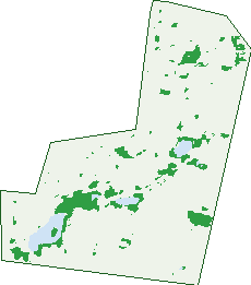
Green: 10 m cells where trees dominate, satellite 2021. Blue: water. The line is the suburb boundary.
| Canopy share, 1 m canopy height map, 2020 | 0.9% |
|---|---|
| Land with trees, 10 m satellite map, 2021 | 7.0% |
Demographics
Unemployment 4% · Labour-force participation 79.5%
Population by age in Franklin
| 0-4 | 536 |
|---|---|
| 5-14 | 971 |
| 15-19 | 357 |
| 20-24 | 622 |
| 25-34 | 1,938 |
| 35-44 | 1,484 |
| 45-54 | 864 |
| 55-64 | 409 |
| 65-74 | 222 |
| 75-84 | 58 |
| 85+ | 14 |
Dwelling types in Franklin
| House | 1,299 |
|---|---|
| Townhouse | 350 |
| Apartment | 955 |
| Other | 0 |
Households by weekly income in Franklin
| <$650 | 134 |
|---|---|
| $650-1,499 | 412 |
| $1,500-2,999 | 1,044 |
| $3,000+ | 874 |
Top ancestries in Franklin
| Other | 2,053 |
|---|---|
| Australian | 1,468 |
| English | 1,314 |
| Chinese | 1,152 |
| Indian | 717 |
| Irish | 402 |
Housing tenure in Franklin
| Owned | 267 |
|---|---|
| Mortgage | 1,078 |
| Rented | 1,198 |
| Other | 31 |
Cars per household in Franklin
| 0 | 134 |
|---|---|
| 1 | 1,061 |
| 2 | 1,024 |
| 3 | 248 |
| 4+ | 103 |
Commute to work in Franklin
| Car | 2,930 |
|---|---|
| Train | 10 |
| Bus | 46 |
| Tram/ferry | 376 |
| Walked | 46 |
| Bicycle | 25 |
| Home | 408 |
Top countries of birth in Franklin
| China | 686 |
|---|---|
| India | 646 |
| Nepal | 384 |
| Vietnam | 181 |
| South Korea | 165 |
| Sri Lanka | 120 |
Languages used at home in Franklin
| Mandarin | 808 |
|---|---|
| Nepali | 397 |
| Vietnamese | 214 |
| Punjabi | 209 |
| Korean | 179 |
| Hindi | 175 |
Birds & Wildlife Nearby
276,679 bird observations recorded near Franklin — most often seen:
- Australian Magpie (16,998)
- Sulphur-crested Cockatoo (15,986)
- Galah (15,623)
- Magpie-lark (15,113)
- Crimson Rosella (13,624)
- Common Starling (13,019)
- Australian Raven (12,493)
- Eastern Rosella (12,024)
- Pied Currawong (11,641)
- Red Wattlebird (11,502)
- Crested Pigeon (10,983)
- Noisy Miner (10,496)
- Australian Wood Duck (9,410)
Show all 30 birds recorded near Franklin
- Common Myna (8,850)
- Pacific Black Duck (8,700)
- Striated Pardalote (7,443)
- Superb Fairy-wren (7,131)
- Red-rumped Parrot (6,945)
- Welcome Swallow (6,906)
- Yellow-rumped Thornbill (6,873)
- Eurasian Coot (6,673)
- Weebill (6,552)
- Willie Wagtail (6,371)
- House Sparrow (5,768)
- Black-faced Cuckoo-shrike (5,230)
- Silvereye (5,145)
- Australian White Ibis (5,028)
- Laughing Kookaburra (4,763)
- Grey Fantail (4,696)
- Eurasian Blackbird (4,693)
Sightings reported by observers, not a survey, so the counts show what people record rather than what lives here. Source: Atlas of Living Australia.
Nearby Suburbs
The closest suburbs to Franklin:
Embed this suburb
Add this free Franklin stat card to your own site — just copy the code:
Preview:
Cite this page
Quoting these figures? Copy the credit line:
Keep an eye on Franklin
One email when this data meaningfully changes — new census figures, prices, rankings. No spam, unsubscribe anytime.
Streets
- Aldous Street (10)
- Alec Hope Crescent (40)
- Alice Crist Street (15)
- Amiet Street (2)
- Amy Witting Street (20)
- Ballantyne Crescent (20)
- Barbara Jefferis Street (22)
- Basham Street (13)
- Bellear Gardens (7)
- Bright Street (4)
- Brissenden Street (5)
- Buzo Gardens (7)
- Charlotte Barton Street (29)
- Christina Stead Street (151)
- Clare Burton Crescent (212)
- Daniels Street (28)
- Diane Barwick Street (6)
- Donald Horne Circuit (48)
- Dorothy Green Crescent (15)
- Dreyer Street (5)
- Dymphna Place (7)
- Eleanor Dark Lane (2)
- Elizabeth Jolley Crescent (136)
- Ellinor Walker Street (13)
- Epstein Street (8)
- Eve Langley Street (7)
- Flemington Road (727)
- Flora Bassett Street (16)
- Gavin Long Street (15)
- Gentile Street (5)
- Gladys Lister Street (31)
- Grimstone Place (17)
- Gwen Harwood Lane (1)
- Gwen Meredith Loop (68)
- Haenke Street (2)
- Henry Kendall Street (377)
- Hesba Brinsmead Street (31)
- Hewett Crescent (11)
- Hinde Street (11)
- Hoskins Street (49)
- Idriess Lane (2)
- Isaacson Street (11)
- Jeannie Gunn Street (21)
- Joan Bradley Street (21)
- Joan Long Street (13)
- Jocelyn Brown Street (16)
- Judith Wright Street (36)
- Katie Stow Lane (2)
- Knorr Street (1)
- Kylie Tennant Street (31)
- Liddell Street (12)
- Littlejohn Lane (12)
- Maclurcan Street (15)
- Manning Clark Crescent (77)
- Marie Pitt Street (44)
- Maris Street (5)
- Marjorie Barnard Lane (1)
- Marlowe Street (2)
- Mavis Latham Street (33)
- Minnie Bruce Street (31)
- Morris West Street (28)
- Nancy Cato Street (30)
- Newell Street (7)
- Nina Murdoch Crescent (15)
- Nullarbor Avenue (87)
- Olga Masters Street (21)
- Oodgeroo Avenue (126)
- Outhwaite Street (14)
- Pape Street (14)
- Patchett Street (5)
- Patrick White Circuit (59)
- Petherick Street (30)
- Phipson Street (8)
- Pownall Street (9)
- Poyitt Street (8)
- Rolls Street (12)
- Roxburgh Street (6)
- Ruth Bedford Street (27)
- Sanger Street (6)
- Stivens Lane (2)
- Stonehouse Street (15)
- Thea Astley Crescent (8)
- Thiele Gardens (7)
- Tomasetti Crescent (9)
- Trist Street (33)
- Walling Street (4)
- Whitington Street (22)
- Wildman Street (6)